
Kaiserleibrücke
Coordinates: 50 ° 6 ′ 40 ″ N , 8 ° 44 ′ 8 ″ E
|
|
||
|---|---|---|
 |
||
| use | Road bridge pedestrian bridge |
|
| Crossing of | Main | |
| place |
Frankfurt-Ostend Offenbach-Kaiserlei (Main km 39.16) |
|
| construction | Steel pipe arch bridge | |
| overall length | 220 m | |
| width | 36.70 m | |
| Headroom | 8.30 m | |
| construction time | 1960-1964 | |
| location | ||
|
||

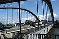
The after Offenbacher district Kaiserlei named Kaiser body skidding on the Main at Main 39.160 kilometers is an arched bridge with an attached bridge deck made of steel. It was built from 1960 to 1964 by the MAN Gustavsburg plant and inaugurated on December 18, 1964. The bridge is part of the A 661 . It connects the north bank of Frankfurt Main with the Offenbach district Kaiserlei on the south side of the Main. The bus line 103 of Offenbacher Verkehrs-Betriebe goes over the bridge to Frankfurt-Bornheim . The bridge is used by almost 117,000 vehicles every day.
construction
The bridge has a main span of 220 meters, and the 4,000 tonne bridge deck has a superstructure width of 36.70 meters with a construction height of 3.1 meters. The crown height is 26 meters. The arches consist of two steel tubes on each side with a diameter of two meters and a wall thickness of twenty millimeters. The abutments stand on a total of 172 piles. The structure has a clearance height of 9.5 meters at the highest shipping water level.
The construction costs amounted to around 15 million DM .
The bridge is part of the Route der Industriekultur Rhein-Main project .
Connections
On the Frankfurt side, the middle lanes lead as the A 661 onto the Ratsweg elevated road towards Oberursel . The up and down lanes go to or come from the Ratswegkreisel , the Ratsweg - Hanauer Landstrasse intersection .
On the side of the roadways Offenbacher A 661 cross on a 600-meter-long high road the Strahlenberger gyro (Offenbach generally Kaiserlei centrifugal called). The entrances and exits lead or come from this roundabout .
gallery

Northern connection to Kaiserleibrücke

Kaiserleibrücke to the south
Kaiserleibrücke, details

View from the south bank


literature
- Wolf-Christian Setzepfandt : Architecture Guide Frankfurt am Main / Architectural Guide . 3. Edition. Dietrich Reimer Verlag, Berlin 2002, ISBN 3-496-01236-6 , p. 53 (German, English).
Web links
Individual evidence
- ↑ a b Route Atlas Main I. (PDF; 11 MB) (No longer available online.) Federal Waterways and Shipping Administration, 2010, p. 44 , archived from the original on January 14, 2015 ; accessed on January 22, 2015 . Info: The archive link was inserted automatically and has not yet been checked. Please check the original and archive link according to the instructions and then remove this notice.
- ↑ Manual road traffic census 2010 of the BVM ( Memento of the original from April 19, 2014 in the Internet Archive ) Info: The archive link was inserted automatically and has not yet been checked. Please check the original and archive link according to the instructions and then remove this notice. (PDF)
- ↑ Local route guide No. 9 of the Route der Industriekultur Rhein-Main. (PDF; 519 kB) In: krfrm.de. KulturRegion FrankfurtRheinMain gGmbH, December 2005, accessed on November 14, 2015 .
- ↑ It's getting tight on the Kaiserleibrücke. faz-archiv.de, May 25, 2011, accessed on September 8, 2013 .
![]() Bridges:
Arthur-von-Weinberg-Steg |
Carl Ulrich Bridge |
Kaiserleibrücke |
Offenbach barrage |
Osthafenbrücke |
Deutschherrnbrücke |
Raftsman Bridge |
Ignatz-Bubis Bridge |
Old Bridge |
Iron Bridge |
Untermainbrücke |
Holbeinsteg |
Peace Bridge |
Main Neckar Bridge |
Old Niederräder Bridge |
New Niederräder Bridge |
Europe Bridge |
Barrage Griesheim |
Schwanheimer Bridge |
Leunabrücke |
Werksbrücke Mitte |
Supply bridge |
Factory bridge west |
Sindling Main Bridge
Bridges:
Arthur-von-Weinberg-Steg |
Carl Ulrich Bridge |
Kaiserleibrücke |
Offenbach barrage |
Osthafenbrücke |
Deutschherrnbrücke |
Raftsman Bridge |
Ignatz-Bubis Bridge |
Old Bridge |
Iron Bridge |
Untermainbrücke |
Holbeinsteg |
Peace Bridge |
Main Neckar Bridge |
Old Niederräder Bridge |
New Niederräder Bridge |
Europe Bridge |
Barrage Griesheim |
Schwanheimer Bridge |
Leunabrücke |
Werksbrücke Mitte |
Supply bridge |
Factory bridge west |
Sindling Main Bridge
![]() Tunnel:
A-tunnel |
City tunnel
-
ferries: Main ferry Höchst
Tunnel:
A-tunnel |
City tunnel
-
ferries: Main ferry Höchst![]()