Rauenberg (trigonometric point)
The TP Rauenberg (TP: Trigonometric Point ) is the fundamental point of the German Main Triangle Network (DHDN).
Locations

The point was on the hill previously known as "Rauenberg" or "Rauhenberg" in the Berlin district of Tempelhof . Since 1985 there has been a monument in the form of the greatly enlarged head section of a granite column , with which trigonometric points on the ground are signaled. The monument is now about ten meters above the historic summit of the Rauenberg. The Marienhöhe (73 m above sea level ) was heaped up with rubble from the destruction of the Second World War between 1949 and 1951 and is now a public green area .
history
The trigonometric point Rauenberg was the fundamental point of DHDN and delivered in from 1832 by Prussia early triangulation of Prussian land survey with the astronomical azimuth direction to the approximately 8.1 kilometers from Berlin Marienkirche at Alexanderplatz , the frame of reference of on the Bessel ellipsoid -based network. This 2D position system is known as the Rauenberg datum , which was also the basis for the Reich triangular network (RDN, 1940) and, since 1945, the German main triangular network. The hill, formerly known as Rauenberg or Rauhenberg, was destroyed around 1910 by the removal of gravel , with which the trigonometric point with its stone pillar and a 21-meter-high wooden base pillar pyramid disappeared without replacement. That is why the Helmert Tower on the Potsdam Telegrafenberg was declared the “central point”. Although this TP was not redefined, but kept its old coordinates - balanced in the Rauenberg datum - since then the Potsdam datum has often been incorrectly referred to . However, the date of the DHDN was still based on the original specifications at TP Rauenberg.
function
As long as most of the official survey points in Germany referred to the DHDN ( Gauß-Krüger coordinates ), the map series - and thus, for example, property boundaries - implicitly reflected the historical significance of this fundamental point. Technically and geodetically, however, the point and today's mark as a replica no longer has any significance, since the change from the German geodetic coordinate system to the ETRS89 system has been decided nationwide and has already been implemented in most federal states.
monument
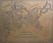
The monument itself is due to an initiative of the Working Group of the Land Surveying Administrations, the Senate Administration for Building and Housing and the DVW Landesverein Berlin e. V. and consists of an oversized, cube-shaped TP stone made of granite, which protrudes from a tower-like structure. On the east and west side, metal plates with a textual explanation of the monument or a picture of the Prussian main triangular network are embedded in the stone. The design for this monument is the result of an ideas competition organized by the Berlin DVW. The monument is located at the geometric location of the former TP, about ten meters above the historic summit of the Rauenberg. Due to the height of the trees around the monument and the buildings in the city, there is no longer a view of St. Mary's Church.
After the technical monument was smeared with graffiti in 2008 and partially destroyed by metal theft , the DVW Berlin-Brandenburg has placed it under protection as a monument at the State Monuments Office. H. application for entry in the list of monuments ; this has not happened to this day. The monument was restored until June 2010 with a contribution from the DVW.
Monument panels
The bronze plate on the east-facing side of the monument bears a text in relief .
| TP RAUENBERG | |||
| GEOGRAPHIC LENGTH | 31 ° 02 '04, ”928 | ||
| EAST OF FERRO | |||
| GEOGRAPHIC WIDTH | 52 ° 27 '12, "021 | ||
| AZIMUT RAUENBERG – BERLIN MARIENKIRCHE | |||
| 19 ° 46 '04, ”87 | |||
|
THE TRIGONOMETRIC POINT 1. ORDER |
|||
|
LENGTH AND WIDTH (LOCATION) AND AZIMUTH ( |
|||
In the copper plate on the west-facing side of the monument, a picture of the Prussian main triangular network with the status of 1900 is engraved .
See also
literature
- Franz Blaser: The Trigonometric Point I. Order Rauenberg , Mitteilungen aus dem Vermessungswesen Berlin, No. 15 (1984)
- Franz Blaser, Günter Bolze: The Monument TP Rauenberg , Communications from Surveying Berlin, No. 16 (1985)
- The Senator for Construction and Housing: The Trigonometric Point I. Order Rauenberg (Flyer), Berlin, 1988
- Hans-Gerd Becker: Monument Trigonometric Point I. Order Rauenberg . In: On the trail of land surveying in Berlin and Brandenburg , 2014, Potsdam, p. 28
Web links
- Flyer The trigonometric point 1st order Rauenberg (PDF; 3.6 MB)
- Hans-Gerd Becker: Monument Trigonometric Point I. Order Rauenberg . In: On the trail of land surveying in Berlin and Brandenburg (PDF file; 10832 kB)
Individual evidence
- ↑ Christian Simon: The "Mountains" in Steglitz. In: Steglitzer Heimat , bulletin of the Heimatverein Steglitz e. V., No. 53 (2008) H. 2, p. 47 f.
Coordinates: 52 ° 27 '6.9 " N , 13 ° 21' 58.6" E


