
Airlift Square
|
Square |
|
|---|---|
|
|
|
 Airlift square in front of the former Tempelhof Airport |
|
| Basic data | |
| place | Berlin |
| District | Tempelhof |
| Confluent streets |
Mehringdamm , Tempelhofer Damm , Columbiadamm , Dudenstrasse, Manfred-von-Richthofen-Strasse |
| Buildings |
Airlift Memorial , former Tempelhof Airport |
| use | |
| User groups | Pedestrians , cyclists , road traffic , public transport |
The Platz der Luftbrücke , or Pladelu for short , is a Berlin traffic junction on the border between the districts of Tempelhof and Kreuzberg . The entrance to the former Tempelhof Airport is located on the square . The buildings around the square mainly house public administration facilities, especially the police headquarters . Not far away is the Viktoriapark as a place to relax. The name of the square is a reminder of the Berlin Airlift of 1948/1949. The square has existed since the construction of the new airport building, but was not given a name in the official maps.
Transport hub
In the square, the Berlin north-south crossing highway of national highway 96 ( Mehringdamm , Tempelhofer Damm west link from East) with the Neukölln ( Columbiadamm ) to Schöneberg (Dudenstraße). In the southwest of the square, Manfred-von-Richthofen-Straße leads to the Neu-Tempelhof area .
At the north end of the square offering Platz der Luftbrücke the underground line U6 connecting to the high-speed traffic in Berlin. From 1926 to 1937 the station was called Kreuzberg . The access for passengers to the former airport is on the square.
buildings
On the east side of the square is the former airport terminal, designed by the architect Ernst Sagebiel, and the administration building built in the same style. These buildings already resemble those that were envisaged in the plans of the National Socialists in the course of the fundamental transformation of Berlin into the " World Capital Germania ". A monumental north-south axis was to be built about one kilometer to the west, to which the airport square would have been connected.
The residential and commercial buildings in the southwest of the square were designed by Bruno Möhring before the First World War .
The airlift memorial , which is also popularly known in Berlin as the “hunger claw” or “hunger rake”, has stood on the square in front of the airport complex since 1951 . There are two comparable counterparts : at Frankfurt Airport and in Celle .
In the access area of the former terminal building there is a statue in the shape of an eagle's head. This is the original head of the 4.50 meter high eagle, which was originally a recognizable feature on the roof of the building from 1940 onwards. Contrary to popular belief, it did not have a swastika in its claws (as with the imperial eagle ), but a globe - analogous to the plans for the lantern on the dome of the great hall of the planned “world capital Germania”. He had to give way in 1962 due to the installation of a new radar system and was the Museum of the US Military Academy at West Point in the American state of New York passed. The eagle, also designed by Sagebiel, was made by the sculptor Walter E. Lemcke and is repeated as a motif on the side buildings in the forecourt. Only this headboard is left of the statue. It was retrieved by the US Air Force and presented to Berliners again as Eagle Square since August 1985.
- Eagle Square

Eagle Head Statue (Eagle Square)
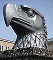
Eagle head on the base of Eagle Square

Memorial plaque on the base of the eagle head statue in Eagle Square, Airlift Square 5


_Eagle_Square11.JPG)
Facilities on site

The headquarters of the Berlin police are located at the airlift square and in the immediate vicinity, with the police headquarters and the state criminal investigation office . This also includes the police history collection .
In the part of the building, known today as Columbiahaus , there are offices of the Federal Securities Administration (BWPV), the Main Customs Office Berlin (HZA), the Federal Examination Office (PAB), the Waterways and Shipping Office (WSA), the Waterway Construction Office (WNA) and the Customs Investigation Office Berlin-Brandenburg ( ZFA).
The central lost property office is responsible for all of Berlin.
Fassberg
In the Lower Saxony municipality of Faßberg , one of the three starting points of the airlift in West Germany, there is also an official street name “Platz der Luftbrücke”.
Web links
- Airlift Square. In: Street name lexicon of the Luisenstädtischer Bildungsverein (near Kaupert )
- Platz der Luftbrücke ( Memento from September 21, 2008 in the Internet Archive ) at the Humboldt University
- Entry in the Berlin State Monument List
- From Tempelhofer Feld to Berlin-Tempelhof Central Airport
Individual evidence
- ↑ Werner Schmidt: Police radio: Frankfurter Allee is called “Sachsendamm” by officials . In: Der Tagesspiegel , March 4, 2001.
- ↑ see maps on Histomap
- ↑ Inscription brass plate on the base of the eagle head / Eagle Square
Coordinates: 52 ° 29 ′ 3 ″ N , 13 ° 23 ′ 15 ″ E