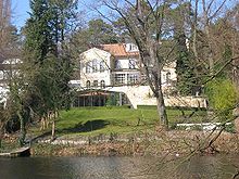
Hubertussee (Berlin-Grunewald)
| Hubertussee | ||
|---|---|---|

|
||
| Hubertussee | ||
| Geographical location | Berlin-Grunewald | |
| Data | ||
| Coordinates | 52 ° 29 '12 " N , 13 ° 16' 48" E | |
|
|
||
| surface | 2.5 ha | |
The Hubertussee is located in the west of the Berlin district of Charlottenburg-Wilmersdorf in the villa colony of Grunewald . It has an elongated shape with an area of around 25,000 m² and is one of four artificial lakes within the tributary of a glacial channel ( Grunewaldseenkette ), which runs from the Schöneberg town hall to the west over the Wilmersdorf park to the Herthasee and at the Koenigssee perpendicular to the chain of lakes meets. There is a small island in the lake.
Patron saint of hunting
The Hubertussee is fed by the Herthasee, with which it is directly connected by a ditch. A part of the not yet completed “Uferwanderweg Grunewald” leads along the ditch, which is supposed to connect the small lakes and the city center with the Grunewald forest on a continuous green corridor. At the Hubertussee alone, this path has been completed along the entire length of the south bank with around 730 meters. The path and moat between Lake Herthasee and Lake Hubertus is spanned by the Bismarck Bridge from 1891, which is a protected monument, with sculptures , obelisks and colossal Egyptian sphinxes made of sandstone . The founding fathers of the Grunewald colony named the lake after the Catholic saint and patron saint of hunting Hubertus . The east adjoining Hubertusallee is part of the former bridle path on which the electors rode from the Berlin City Palace over the former Kurfürstendamm Knüppeldamm to hunt in the Grunewald and to the Grunewald Hunting Lodge .
Peat fen and side channel
Like the three other small lakes in the immediate vicinity, Herthasee , Koenigssee and Dianasee , the Hubertussee is not one of the original lakes of the Grunewald chain, but was excavated in 1889 to drain the swampy area during the construction of the Grunewald villa colony. The original name of the stretched valley, "Torffenn", with its Flemish component Fenn (translated: marshy moorland ) indicates the historical, boggy character of the landscape; the first word component peat indicates the advanced silting process of the fen .

To the east, this Ice Age drainage channel is built over around 2.2 kilometers and continues after the city ring in the narrow Fennsee , with which the western part of the Wilmersdorf Park begins. However, the incisions of the former lowland can be seen in many places in the converted urban area - for example east of the Hubertussee at the extensive sports grounds with the Hubertussportplatz, Wilmersdorf stadium , tennis courts and ice rink, and especially at the Wilmersdorf summer pool with its sloping lawn. This green “sports train” extends right up to the motorway. From the ice rink and open-air swimming pool, the sweeping pedestrian suspension bridge "Hoher Bogen" leads over the motorway and the parallel railway tracks of the Ringbahn to the Fennsee and to the neighboring former tourist attraction Wilmersdorfer See with its bathing establishment and the famous Schramm dance palace . “Let's go to Schramm” was one of the winged words of Berliners in the 1880s . The Wilmersdorf seaside resort was filled in after 1915 and converted into a public park, which today continues the side channel of the Grunewald chain of lakes.
Polluted water quality
In addition to the water quality of the Halensee , that of the four artificial Grunewald lakes shows high fluctuations in terms of pollution. Lowering of the groundwater level in Berlin's glacial valley has largely cut off the lakes, which were originally supplied with groundwater, from the natural water supply. Contrary to the original direction of flow, Havel water has been pumped from the Großer Wannsee through the Grunewaldseenkette to the Dianasee since 1913 and from there reaches the following lakes via another pumping station. The Hubertussee receives clean water via the canal from Herthasee.
However, the water problem has worsened in recent years, as necessary maintenance measures such as the removal of leaves can no longer be carried out to the required extent due to a lack of financial means. Due to the fall of leaves, the rain washing in of branches and plants on the high bank areas and the additional water from the rain sewer system, more biomass and nutrient-rich germs get into the lakes. Oxygen consumption during biological degradation and silting are the result, so that the district had deforestation carried out in the bank area to protect the lakes.
Like almost all Berlin lakes, the Hubertussee and its neighbors are fishing waters and are regularly stocked with fish.
See in more detail
- to the "Uferwanderweg Grunewaldseen" and landscape plan: Koenigssee
- to excavate the lakes: Dianasee
- on the term "Fenn" (and general overview): Grunewaldseenkette
- to the "Bismarck Bridge": Herthasee


