
Griebnitz Canal
| Griebnitz Canal | |||||||||||||||||||||||||||||||||||||
|---|---|---|---|---|---|---|---|---|---|---|---|---|---|---|---|---|---|---|---|---|---|---|---|---|---|---|---|---|---|---|---|---|---|---|---|---|---|
 Entrance from the Griebnitzsee |
|||||||||||||||||||||||||||||||||||||
| abbreviation | GrK | ||||||||||||||||||||||||||||||||||||
| location |
|
||||||||||||||||||||||||||||||||||||
| length | 3.61 km | ||||||||||||||||||||||||||||||||||||
| Built | 1906 | ||||||||||||||||||||||||||||||||||||
| class | Inland waterway class I | ||||||||||||||||||||||||||||||||||||
| Beginning | Great Wannsee | ||||||||||||||||||||||||||||||||||||
| The End | Griebnitzsee | ||||||||||||||||||||||||||||||||||||
| Top speed. | 5 km / h | ||||||||||||||||||||||||||||||||||||
| Downhill | to the south | ||||||||||||||||||||||||||||||||||||
| Responsible WSD | WSA Berlin | ||||||||||||||||||||||||||||||||||||
|
course
|
|||||||||||||||||||||||||||||||||||||
The Griebnitz Canal , official abbreviation GrK ; Called Prinz-Friedrich-Leopold Canal from its creation in 1906 to 1951 in the GDR and until 1992 in the Federal Republic of Germany , it is located in the Berlin district of Steglitz-Zehlendorf . It connects the Großer Wannsee , a bay of the Havel , with the Griebnitzsee at the western end of the Teltow Canal . The GrK has a total length of 3.61 km.
The Griebnitz Canal was created with the construction of the Teltow Canal in the years 1901–1906 by connecting existing lakes and was intended to serve both recreational traffic and to improve the water quality of the lakes.
course
It consists of three lakes with a total length of 2.8 km and two canal stretches (together 0.8 km), the northernmost of which is very short below the Wannsee bridge. The Kleine Wannsee connects to the south of the Großer Wannsee and merges into the Pohlesee without a clear border . From there there is a 300 m long connecting canal to Stölpchensee and from there a 500 m long canal to Griebnitzsee, which in turn connects to the Glienicker Lake of the Havel south of the Glienicker Bridge . Legally it is a federal waterway of waterway class I in the jurisdiction of the waterways and shipping office in Berlin .
flow
The flow in the canal is not regulated by weirs, but left to chance. The ascent is the journey in the direction of Großer Wannsee, which means that the canal is defined as a branch of the Havel. All year round, however, the current is mainly directed from the Griebnitzsee towards the Wannsee, so hydrologically the water is more of a branch of the Teltow Canal, which in turn is an artificial branch of the Spree. About a quarter of the flow of the Teltow Canal flows off through the Griebnitz Canal.
Since the Teltow Canal is the most heavily polluted body of water in the Berlin area, this inflow into the Großer Wannsee can have a negative impact on the water quality of the Wannsee lido , especially when the Havel flows calmly .
shore
Large parts of the bank , have settled in the numerous rowing clubs, are in private ownership and public inaccessible.
Traffic control
On the Griebnitz Canal between the Griebnitzsee and the Stölpchensee there is a ban on vehicles that are wider than two meters. In the south, the canal section may be used on the hour and the following 20 minutes, in the north at half an hour and the following 20 minutes. This results in a time buffer of ten minutes in each direction, in which the journey through the canal between the Griebnitzsee and the Stölpchensee must be completed. There are further bans on encounters in the area of the Alsen bridge between the Stölpchensee and the Pohlesee and in the area of the Wannsee bridge. The traffic is regulated according to the inland waterway regulations .
bridges
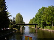
The Wannseebrücke with the B1 ( Königstraße ) leads directly to the Großer Wannsee via the short connection between the large and small Wannsee. The section of canal between the Pohlesee and the Stölpchensee is crossed by the Kohlhasenbrücker Straße on the Alsenbrücke . The third section of the canal between the Stölpchensee and the Griebnitzsee is crossed halfway by the Hubertusbrücke , on which the Stölpchenweg runs. The St. Hubertusbaude (currently closed in 2018) as well as the forester's house and the Hubertusbrücke restaurant are right next to the bridge.
photos
- Griebnitz Canal
Hubertus Bridge

View from the Hubertusbrücke to the north with the Stölpchensee in the background

Church at the Stölpchensee

Alsenbrücke

Wannsee bridge from the little ones to Wannsee seen


See also
Web links
Individual evidence
- ↑ Waterways and Shipping Office Berlin: Griebnitz Canal (GrK), History , accessed on March 17, 2016.
- ↑ Waterways and Shipping Office Berlin: Teltow Canal, History (section Prinz-Friedrich-Leopold-Kanal) , Waterways and Shipping Office Berlin: Prinz-Friedrich-Leopold-Kanal accessed on March 17, 2016.
- ↑ Federal waterways and shipping administration: lengths (in km) of the main shipping routes (main routes and certain secondary routes) of the federal inland waterways. ( Memento of the original from January 21, 2016 in the Internet Archive ) Info: The archive link was inserted automatically and has not yet been checked. Please check the original and archive link according to the instructions and then remove this notice.
- ↑ Federal Waterways and Shipping Administration: Directory E, serial no. 57 der Chronik ( Memento of the original from July 22, 2016 in the Internet Archive ) Info: The archive link was inserted automatically and has not yet been checked. Please check the original and archive link according to the instructions and then remove this notice.
- ↑ Electronic waterway information service (ELWIS), § 21.05 ascent ( memento of the original from March 24, 2016 in the Internet Archive ) Info: The archive link was automatically inserted and not yet checked. Please check the original and archive link according to the instructions and then remove this notice.
- ↑ Senate Department for Urban Development, Berlin: Water Management Monthly Report , issues 12.2009 to 05.2011
- ↑ www.berlin.de, EU bathing area Strandbad Wannsee - bathing water profile
Coordinates: 52 ° 24 ′ 41 ″ N , 13 ° 9 ′ 0 ″ E