blackness
| blackness | ||
|
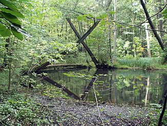
Divining bridge in the blackness |
||
| Data | ||
| Water code | DE : 696266 | |
| location | Brandenburg , Germany | |
| River system | Or | |
| Drain over | Finow Canal → Alte Oder → Hohensaaten-Friedrichsthaler Wasserstraße → Oder → Stettiner Haff | |
| source | as an outflow of the Schwärzesees southwest of Eberswalde 52 ° 48 ′ 34 ″ N , 13 ° 43 ′ 25 ″ E |
|
| Source height | 32 m | |
| muzzle | in the city center of Eberswalde in the Finow Canal Coordinates: 52 ° 50 ′ 8 ″ N , 13 ° 49 ′ 5 ″ E 52 ° 50 ′ 8 ″ N , 13 ° 49 ′ 5 ″ E |
|
| Mouth height | 15 m | |
| Height difference | 17 m | |
| Bottom slope | about 1.8 ‰ | |
| length | about 9.4 km | |
| Discharge at the Eberswalde A Eo gauge : 129 km². Location: 900 m above the mouth |
NNQ (09/29/1982) MNQ 1967/1998 MQ 1967/1998 Mq 1967/1998 MHQ 1967/1998 HHQ (08/09/1970) |
283 l / s 381 l / s 593 l / s 4.6 l / (s km²) 1.48 m³ / s 4.5 m³ / s |
| Left tributaries | Herthafließ | |
| Right tributaries | Nun flow | |
| Medium-sized cities | Eberswalde | |

The Schwärze is a small river in northeast Brandenburg and a right tributary of the Finow Canal . It rises in the Schwärzesee and joins the approximately eleven kilometer long Nonnenfließ after about five kilometers near Spechthausen . The blackness runs mainly in forests and is about 9.4 kilometers long, with Nonnenfließ as a source river about 16 kilometers.
While the blackness in the headwaters on the edge of the Eberswalde glacial valley forms many meanders and cuts deep into the sandy slopes of the beech forests, the middle and lower reaches are very flat. At the southern edge of the Eberswalde zoo , it is widest at around 50 m. The water of the blackness in the upper reaches to Spechthausen has a good to very good water quality and in the lower reaches at the Eberswalde measuring point the water quality class III; occasionally trout can be observed.
At the level of the Zainhammer mill, the blackness is dammed up to form a small lake; Trout were bred here until around 2000. A fish ladder is laid out on this small lake, which is intended to ensure the continuity of the blackness. Also near the Zainhammer Mühle is a small bridge known locally as the "Wünschelbrücke". It is said that wishes that are silently made on her come true. This legend was the talk of the town even before 1900.
Behind the Zainhammer Mühle, the blackness reaches the urban area of Eberswalde , flows through the forest botanical garden Eberswalde and reaches the city center at the foot of the Brunnenberge at the edge of the Weidendamm at the level of the Haus Schwärzetal cultural center . It flows through the city campus of the University for Sustainable Development Eberswalde and flows into the Finow Canal just above the city lock.
In the spring it regularly caused damp cellars in parts of Eberswalde due to floods.
Individual evidence
- ↑ a b according to Google Earth
- ↑ River directory gewnet25 (Version 4.0, April 24, 2014) from the Ministry for Rural Development, Environment and Agriculture of the State of Brandenburg, accessed on May 4, 2015.
- ^ German Hydrological Yearbook Elbe Region, Part II 1998 Brandenburg State Environment Agency, p. 208, accessed on November 3, 2018, at: lugv.brandenburg.de (PDF, German, 5.55 MB).
- ↑ FFH area No. 314: Nonnenfließ-Schwärzetal maintenance and development plan for the Barnim Nature Park, Institute for Ecology and Nature Conservation on behalf of the Brandenburg State Environment Agency, Eberswalde, 2008, p. 7, on: barnim-naturpark.de (PDF, German, 1 , 73 MB)
literature
-
Rudolf Schmidt :
- The Finow Canal. Messages from the Heimatkunde association, 11th year 1938
- History of the city of Eberswalde. Volume 2 from 1740–1940, Eberswalde 1940
- Association for local history in Eberswalde e. V .: Eberswalder Yearbook 2004/2005 ISSN 1616-1882

