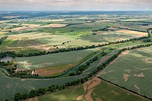
Old Or
Alte Oder is the name of numerous old arms of the Oder in Brandenburg (Germany), which were caused by the construction of piercings and the like. a. to improve the drainage . In the 18th century, an entire puncture and embankment program was carried out in the area of the Oderbruch between Lebus and Hohensaaten and also downstream .
Güstebiese – Wriezen – Hohensaaten
The Güstebieser (15 km) and the Wriezener Alte Oder (25 km) were the main stream of the Oder until the construction of the major breakthrough between Güstebiese and Hohensaaten 1747–1753, the 21 km long Oder Canal. Today they absorb all surface water from the Oderbruch, which was made possible by lowering the water level by approx. 3.5 m compared to the main stream. The Güstebieser Alte Oder begins on the Oder dike at Güstebieser Loose and flows south-west to Wriezen . From here it is the Wriezener Alte Oder, which turns to the northwest and flows between the town of Bad Freienwalde (Oder) and its district of Schiffmühle in a wide arc through the Niedere Oderbruch (partly nature reserve) west of the Neuenhagen island to the northeast.
From Bralitz to Oderberg (HOW-km 84.69) the Wriezener Alte Oder (WAO) is a federal waterway of waterway class III over a length of 2.5 km ; The Eberswalde Waterways and Shipping Office is responsible . From Oderberg, the Havel-Oder waterway uses the lowest 7.8 km long section of the Old Oder. The water level of this so-called Oder hold is 1.2 m above sea level. It is connected to the two meters higher Oder (middle level here 3.24 m above sea level) via the Hohensaatener Ostschleuse. However, the water drains into the Hohensaaten-Friedrichsthaler Wasserstraße , the level of which is only 0.4 m above sea level and with which the Oder hold is connected by a weir and the Hohensaatener Westschleuse.
The former district town of Bad Freienwalde still bears the official name of Bad Freienwalde (Oder) , although the main river of the Oder today runs 8 km to the northeast. The city of Oderberg is also 7 km west of today's Oder.
Reitwein – Wriezen
The southern Alte Oder is somewhat longer, but significantly smaller, and before the Oderbruch was drained, a left branch of the Oder. It has its current origin near Reitwein, the original branch at the foot of the Reitweiner Sporn near Lebus . From there it flows northwards first as Bullergraben and then as Manschnower Alte Oder, then bends sharply to the west north of Gorgast and reaches the western edge of the lowland near Gusow (north of Seelow ). From here it runs in a north-westerly direction and is led north of Neuhardenberg as the Quappendorfer Canal . The last 13 kilometers from the mouth of the Stöbber to the confluence with the Wriezener Alte Oder in Wriezen are called Friedländer Strom.
Around two kilometers northwest of the junction of the Stöbber and Quappendorfer Canal, the Friedlander Strom flows into the Perschegraben (also: Klostergraben), which drains a wet biotope into the Ringenwalder Heide via the Dolgensee , Kesselsee , Lettinsee and Klostersee lakes .
At Zechin u. a.
To the north-east of Zechin there are still remnants of the former 4 km long Alte Oder as a result of the breakthrough at Genschmar in 1787, but they are neither connected to the Oder nor to each other.
There are other bodies of water called "Alte Oder" near Küstrin-Kietz (opposite Küstrin ) since 1736, but also in Frankfurt and in the Lower Oder Valley National Park near Criewen since 1788 and near Zützen .
literature
- M. Eckholdt (Ed.), Rivers and Canals, The History of German Waterways, DSV-Verlag 1998
- Brandenburg Water Division Ordinance of December 1, 2008, Law and Ordinance Gazette for the State of Brandenburg Part II - No. 31 of December 17, 2008
Individual evidence
- ↑ Annex to the Prussian Water Act of April 7, 1913, Collection of Laws No. 14.
- ↑ a b Lengths of the main shipping lanes of the federal inland waterways, List 1 (PDF, Version 3.2, 2019). Federal Waterways and Shipping Administration.
- ↑ Directory E, Ser. No. 21 of the chronicle on the legal status of the Reich waterways / inland waterways of the federal government. Federal Waterways and Shipping Administration, 1998.

