
Thorn-Eberswalder glacial valley


The Thorn-Eberswalder Urstromtal is a Talniederung of Bydgoszcz , Gąbin and Włocławek about Toruń , Nakło nad Notecią , Trzcianka , Czarnków , Kiszewo , Gorzow Wielkopolski , Kostrzyn nad Odra , Bad Freienwalde , Niederfinow , Eberswalde , Liebenwalde and Kremmen until after Fehrbellin . It is the northernmost and therefore the youngest of the three great Brandenburg glacial valleys that were formed during the Vistula Ice Age .
This glacial valley joins the Warsaw-Berlin glacial valley to the west of Fehrbellin . The combined valleys flow into the Elbe glacial valley near Havelberg .
Emergence
The Thorn-Eberswalder glacial valley was created in the periglacial climate of the Pleistocene when the meltwaters of the glaciers ran off parallel to the ice edge during the Pomeranian phase of the Vistula glaciation from around 18,000 to 15,000 BC. BC, making it the youngest and most northerly of the three large glacial glacial valleys in Brandenburg and Poland . Lüthgens, Böse and Preusser determined the age of the sand areas at Althüttendorf starting at the ice edge as 18150 ± 1600 years BC. And at Eberswalde with 17450 ± 2400 years BC. Chr.
The blockage of the rivers in the north by the continental glacier caused the valley to be up to 20 kilometers wide. It has a flat bottom on which there are often peat areas several kilometers wide .
geology
The thickness of the valley sand is mostly more than 10 and sometimes even more than 20 meters. This sand is deposited on the sediments of the Saale Glaciation and is fine to medium-grained in the upper layers, e.g. Sometimes slightly silty. With increasing depth it becomes coarser and often contains gravelly additions.
Landscapes
Poland
In the Polish part of the Thorn-Eberswald glacial valley , the macroregion 315.3 ( Pradolina Toruńsko-Eberswaldzka ), the following landscapes are located:
- Mezoregion 315.31 Freienwalder Basin
- Mezoregion 315.32 Gorzów Basin with the micro-regions:
- Lower Netzetal
- Obornicka valley
- Lower Warth Valley
- Land between Warta and Netze
- Mezoregion 315.33 Middle Netzetal
- Mezoregion 315.34 Thorner Basin
- Mezoregion 315.35 Płock basin with the micro-regions:
- Brwilna-Radziwia plain
- Duninowska Plain
- Włocławska plain
- Łąckie Lake District
- Gostynińskie Lake District
- Rakutowskie Depression
Between the Płock Basin and the Thorner Basin, the Vistula Valley near Nieszawa creates a breakthrough that narrows to a few kilometers.
Germany
German territory reaches the Eberswalder Urstromtal near Küstrin an der Oder , coming from Toruń (hence the name Thorn-Eberswalder Urstromtal, which also includes the Polish part ) , it follows the course of the Oderbruch to the northwest of Bad Freienwalde (Oder) , leaving the Oderbruch near Niederfinow then runs via Eberswalde , Liebenwalde and Kremmen in a westerly direction. The glacial valley crosses the Zehdenick-Spandau Havel lowlands . To the west of Fehrbellin , it joins the Berlin glacial valley and a little further west near Havelberg with the Elbe glacial valley and the Baruther glacial valley . The glacial valley is framed both north and south by mountain ranges formed during the Ice Age . In the south, the rows from east to west plates Lebus , Barnim and Ländchen ganglia together. Between Barnim and Glien there is a glacial valley , with which the Eberswalder glacial valley is connected to the Berlin glacial valley. The breakdown north of the glacial valley is more complicated, as the subdivision into slabs and little lands is not common there.
It is important, however, that the Pomeranian Ice Edge lies north of the glacial valley . The glacial valley owes its creation to the melt waters that flowed off this terminal moraine . There are extensive sand areas between the Pomeranian ice rim and the glacial valley . The best known is the Schorfheide .
The Eberswalde glacial valley, like all glacial valleys, is built up from mighty sands, some of which can reach a thickness of more than 20 meters. In the urban area of Eberswalde and to the east of the city, however, there are also fine-grained ice reservoir sediments ( clays and silts ) under a thin cover of sand , which were mined in clay pits in the 19th and 20th centuries.
The surface of the valley is ideally flat. This character has only survived extensively west of Eberswalde. The Oderbruch to the east is younger in its design and its floor is also significantly deeper than the Eberswalder glacial valley. Because of this, the Finow river in the urban area of Eberswalde and east of the city has cut very strongly into the floor of the glacial valley. In addition, the ice advanced significantly further south during the Vistula Ice Age. When the ice melted in the area of the Eberswalder glacial valley, numerous bodies of dead ice formed due to the meltwater activity, which subsequently thawed out and now forms lakes or damp lowlands. Furthermore, at the end of the Vistula Ice Age, extensive dunes were blown up, especially on the southern edge of the glacial valley, which clearly enliven the otherwise flat landscape. The western section of the glacial valley, on the other hand, is mostly flat and is occupied by large, extensive moorland (e.g. the Rhinluch ).
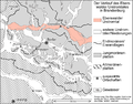
The course of the Eberswalder glacial valley in Brandenburg

Exposure wall with well-layered band clay deposits in Macherslust near Eberswalde

Rivers
The geologically elongated shape is used by many rivers, such as:
- Brda - mouth near Bydgoszcz
- Vistula from Bydgoszcz to Toruń
- Netze - confluence with Santok in the Warta
- Warta
- Or
- Havel
See also
Web links
- Diercke World Atlas: Nordic glaciations. Verlag Westermann, ISBN 978-3-14-100758-9 , p. 2, Fig. 1, scale 1: 1,200,000 ( online )
literature
- Herbert Liedtke: The Nordic glaciations in Central Europe. (= Research on German regional studies. 204). 2., ext. Central Committee for German Regional Studies, Trier 1981, ISBN 3-88143-020-2 .
Notes and individual references
- ↑ on the Havel just before it flows into the Elbe
- ↑ Piotr MIGON: Geomorfologia. Wydawnictwo Naukowe PWN , Warsaw 2006, ISBN 83-01-14812-8 , pp. 353-355.
- ↑ C. Lüthgens, M. Böse and F. Preusser: Age of the Pomeranian ice marginal position in north-eastern Germany determined by Optically Stimulated Luminescence (OSL) dating of glaciofluvial sediments . In: Boreas . 2011, doi : 10.1111 / j.1502-3885.2011.00211.x .
- ↑ Krystian Chariza: Atlas Geograficzny dla Szkół ponadgimnazjalnych. Wydawnictwo Nowa Era, Warsaw 2012, ISBN 978-83-267-0775-9 , pp. 80-81.
- ↑ Polish: Pradolina Toruńsko-Eberswaldzka = English: Macroregion 315.3 Toruń-Eberswalde Glacial Valley
- ↑ Polish: Kotlina Freienwaldzka (315.31) = English: Mezoregion 315.31 Freienwalde Basin
- ↑ Polish: Kotlina Gorzowska (315.32) = English: Mezoregion 315.32 Gorzów Basin
- ↑ Polish: Dolina Dolnej Noteci
- ↑ Polish: Obornicka Dolina Warty
- ↑ Polish: Dolina Dolnej Warty
- ↑ Polish: Międzyrzecze Warty i Noteci. - the intermediate river country
- ↑ Polish: Dolina Środkowej Noteci (315.32) = English: Mezoregion 315.33 Central Noteć Valley
- ↑ Polish: Kotlina Toruńska (315.34) = English: Mezoregion 315.34 Toruń Basin
- ↑ Polish: Kotlina Płocka (315.35) = English: Mezoregion 315.35 Płock Basin
- ↑ Polish: Równina Brwilna-Radziwia.
- ↑ Polish: Równina Duninowska
- ^ Polish: Równina Włocławska
- ↑ Polish: Pojezierze Łąckie
- ↑ Polish: Pojezierze Gostynińskie
- ↑ Polish: Obniżenie Rakutowskie