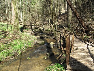
Sophienfliess
| Sophienfliess | ||
|
Lower course of the Sophien river shortly after the dragon throat |
||
| Data | ||
| Water code | DE : 696224 | |
| location | Märkische Schweiz , Märkisch-Oderland district , Brandenburg , Germany | |
| River system | Or | |
| Drain over | Schermützelsee → Werderfließ → Buckowsee (Buckow) → Stobber → Friedländer Strom → Alte Oder → Hohensaaten-Friedrichsthaler Wasserstraße → Oder → Stettiner Haff | |
| origin | Castle lake near Prötzel 52 ° 38 ′ 1 ″ N , 13 ° 59 ′ 36 ″ E |
|
| Source height | 77 m above sea level NHN | |
| muzzle | in Buckow in the Schermützelsee Coordinates: 52 ° 34 '5 " N , 14 ° 4' 2" E 52 ° 34 '5 " N , 14 ° 4' 2" E |
|
| Mouth height | 27 m above sea level NHN | |
| Height difference | 50 m | |
| Bottom slope | 5 ‰ | |
| length | 10 km | |
| Catchment area | 48.5 km² | |
| Discharge at the mouth of the A Eo : 48.5 km² |
MQ 1977-1984 Mq 1977-1984 |
210 l / s 4.3 l / (s km²) |
| Small towns | Buckow | |
| Communities | Prötzel , Oberbarnim | |
The Sophienfließ is a creek almost 10 kilometers long in Märkische Schweiz in Brandenburg .
course
The river is fed by the Schloßsee , located in the Märkische Schweiz nature park near Prötzel . Its upper course on the Barnim near Prötzel and Grunow has been remodeled by human intervention and has also been ecologically severely impaired by the discharge of nutrient-rich wastewater and is currently (2011) being renatured. In the lower reaches, however, a natural state of the river has been preserved. After a total of almost ten kilometers, the Sophienfließ flows into the Schermützelsee in the Buckower Kessel from the north . In the annual mean from 1977 to 1984 the river supplied the Schermützelsee with 3.5 million m³ of water annually. Under the name Werderfließ , the water enriched with groundwater leaves the Schermützelsee on the eastern shore and after a few hundred meters reaches the Buckowsee , through which the Stobber flows.
A Fontanewanderweg runs along the Sophien river . The natural monument root spruce is located on the river .
Natura 2000, FFH area
The lower course of the Sophien river in the Barnimsüdhang is part of the coherent European ecological network of special protected areas Natura 2000 . Among the ten FFH areas of the Märkische Schweiz nature park for the preservation of natural habitats as well as wild animals and plants, it is assigned to the FFH area “Tornowseen- Pritzhagener Berge”. The profile of the Federal Agency for Nature Conservation (BfN) contains the following description for the 682 hectare area under number 3450-306:
"Richly structured compression terminal moraine complex with pronounced notch valleys formed in historical forest clearing periods , the dystrophic Small and the eutrophic Great Tornowsee , natural deciduous mixed forests and the natural Sophienfließ."
Naming
The brook is named after the female given name Sophie (Σοφία, Greek for "wisdom"). According to the Brandenburg name book, the namesake could no longer be determined. The first known written entry ( Sophien Fließ ) is the Prussian original table sheet from 1841. The previous name was Stanitz-Fließ and is still used for the upper reaches near Prädikow.
Web links
Individual evidence
- ↑ a b c Nature Park Märkische Schweiz: Sophienfließ .
- ↑ Measurement in the Brandenburg Viewer , accessed on February 15, 2016
- ↑ a b Brigitte Nixdorf, Mike Hemm u. a .: Documentation of the condition and development of the most important lakes in Germany, part 5, Brandenburg , environmental research plan of the Federal Ministry for the Environment, Nature Conservation and Nuclear Safety , final report R&D project FKZ 299 24 274, on behalf of the Federal Environment Agency at the Chair of Water Protection at the Brandenburg University of Technology Cottbus , 2004 Chapter 1.26 Schermützelsee p. 112f PDF .
- ^ LAG Märkische Schweiz e. V .: Natural area Märkische Schweiz.
- ↑ 3450-306 Tornowseen - Pritzhagener Berge. (FFH area) Profiles of the Natura 2000 areas. Published by the Federal Agency for Nature Conservation . Retrieved November 21, 2017.
- ↑ Brandenburg name book. Part 10: The names of the waters of Brandenburg . Founded by Gerhard Schlimpert , edited by Reinhard E. Fischer . Edited by K. Gutschmidt, H. Schmidt, T. Witkowski. Berlin contributions to name research on behalf of the Humanities Center for History and Culture of East Central Europe eV Verlag Hermann Böhlaus Nachhaben, Weimar 1996, ISBN 3-7400-1001-0 , p. 267.
- ↑ Berghaus, Heinrich, Landbuch der Mark Brandenburg und des Markgrafthums Nieder-Lausitz in the middle of the 19th century or geographical-historical-statistical description of the Mark Brandenburg . First volume, Brandenburg 1854: Published by Klaus-D. Becker, Potsdam, 2013 (Unchanged reprint), p. 74
