Märkische Schweiz
The Märkische Switzerland is a hilly landscape in the district Oderland in the state of Brandenburg in ( Germany ).
geography
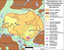
Märkische Schweiz is located almost 30 km northeast of Berlin on the Barnim plateau . The landscape relief was formed in the Ice Ages . Märkische Schweiz is partially designated as a nature park of around 205 km², Märkische Schweiz , although its area does not represent the entire Märkische Schweiz. The nature park mainly includes the southern areas around Buckow , but not the central and northern areas around Bad Freienwalde (Oder) . There are several landscape protection and nature reserves in the area of the nature park . In the north, near Bad Freienwalde (Oder) and Falkenberg , Märkische Schweiz borders directly on the Schorfheide-Chorin biosphere reserve and the Oderbruch , the largest inland polder in Germany.
The highest elevation of the hilly and wooded area is the Semmelberg ( 158 m above sea level ) near Bad Freienwalde (Oder) . For Brandenburg conditions, the compression areas there are extremely rich in relics. With differences in altitude of well over 100 meters over a horizontal distance of less than 1 km, the area immediately south of Bad Freienwalde is the region with the greatest relief in Brandenburg. The formation of dry valleys at the end of the Vistula Ice Age strengthened the relief there .
history
Historically, the northern springs of Märkische Schweiz are mentioned as early as the 17th century under the Great Elector , who, because of their great healing powers, ushered in the beginning of the bathing era in Bad Freienwalde (Oder) , then still Freienwalde. Even today, this can be clearly seen from the resort architecture .
Since the 1920s, Bad Freienwalde (Oder) has become a popular winter sports destination for Berliners.
Waters
The central flowing water in the south of Märkische Schweiz is the Stobber . The stream rises on the North Sea-Baltic Sea watershed , so that it has two directions of flow and mouths. Its apex area with the pseudobifurcation is 48 m above sea level. NN in the Rotes Luch moorland . The shorter south-western part joins after about 6 kilometers between the Maxsee and the Liebenberger See with the Mühlenfließ coming from the Maxsee to the Löcknitz , which drains over the Flakensee and Dämeritzsee into the Spree and thus over the Havel and Elbe into the North Sea. This shorter part of the Stobber is mostly called Stobberbach or Stöbberbach to distinguish it; until the 19th century this watercourse was called Köpernitz . The 25 km long north-eastern main part flows from the Roten Luch through Buckow to the Oderbruch . At Altfriedland it unites with the Quappendorfer Canal to form the Friedländer Strom , whose water is fed to the Baltic Sea via the Alte Oder , the Hohensaaten-Friedrichsthaler Wasserstraße and the Oder in the Stettiner Haff . The Alte Oder is also the river that delimits Märkische Schweiz in the east and north. The numerous clear brooks of the Hohen Barnim , which arise in the central and northern areas of the Märkische Schweiz , flow into it .
tourism
The city of Buckow , a Kneipp spa town , located centrally within the nature park, is traditionally the tourist center in the south of Märkische Schweiz . In the north it is the town of Bad Freienwalde (Oder) , at the same time the oldest health resort in the Mark Brandenburg and moor spa .
Today the northernmost training location of the German Ski Association is in Märkische Schweiz . The longest natural toboggan run in the North German lowlands is also located along the dry valleys . Over a length of 870 m, about 80 meters of altitude are overcome.
Others
Theodor Fontane described the region in the walks through the Mark Brandenburg as follows:
“But where is the real Märkische Schweiz located? We will have to put up with a dualism , as well as otherwise. Freienwalde is a lady after all, Buckow is a rural beauty who steps into the lake with bare feet and braids her hair under willow branches. Now everyone choose according to their sense "
The Great Brockhaus in its edition from 1929 (15th edition) illustrates the location of Märkische Schweiz with its maps (see illustration).
Web links
Individual evidence
- ^ Werner Stackebrandt: Atlas for the geology of Brandenburg . Ed .: Volker Manhenke. 2nd Edition. State Office for Geosciences and Raw Materials Brandenburg (today: State Office for Mining, Geology and Raw Materials Brandenburg, LBGR), Kleinmachnow 2002, p. 142 (43 cards).
- ↑ Theodor Fontane: The Oderbruch and its surroundings . In: Theodor Fontane (Hrsg.): Walks through the Mark Brandenburg . II, The Oderland, 1892.
Coordinates: 52 ° 34 ' N , 14 ° 5' E


