
Strzelce Krajeńskie
| Strzelce Krajeńskie | |||
|---|---|---|---|

|
|
||
| Basic data | |||
| State : | Poland | ||
| Voivodeship : | Lebus | ||
| Powiat : | Strzelecko-Drezdenecki | ||
| Area : | 4.94 km² | ||
| Geographic location : | 52 ° 53 ' N , 15 ° 31' E | ||
| Height : | 72 m npm | ||
| Residents : | 9950 (Jun. 30, 2019) |
||
| Postal code : | 66-500 | ||
| Telephone code : | (+48) 95 | ||
| License plate : | FSD | ||
| Economy and Transport | |||
| Street : | Droga krajowa 22 : Kostrzyn nad Odrą / Germany - Grzechotki / Russia | ||
| Droga wojewódzka 156 : Lipiany - Drezdenko | |||
| Rail route : | PKP line 203: Kostrzyn nad Odra / Germany – Tczew | ||
| Strzelce Krajeńskie Wschód – Strzelce Krajeńskie | |||
| Next international airport : | Szczecin-Goleniów | ||
| Gmina | |||
| Gminatype: | Urban and rural municipality | ||
| Gmina structure: | 36 villages | ||
| 22 school authorities | |||
| Surface: | 318.57 km² | ||
| Residents: | 17.052 (June 30, 2019) |
||
| Population density : | 54 inhabitants / km² | ||
| Community number ( GUS ): | 0806043 | ||
| Administration (as of 2015) | |||
| Mayor : | Mateusz pen | ||
| Address: | pl. Wolności 48 66-500 Strzelce Krajeńskie |
||
| Website : | www.strzelce.pl | ||

(GermanFriedeberg (Neumark)) is a small town in the PolishLebus Voivodeship. It is also the official seat of thePowiat Strzelecko-Drezdenecki (Friedeberg-Driesen district). TheGmina Strzelce Krajeńskieis asmall town building, which has its headquarters in Strzelce Krajeńskie.
Geographical location
Strzelce Krajeńskie is located in Neumark , between the Pomeranian ridge and the Netzebruch . The next larger town is Gorzów Wielkopolski ( Landsberg an der Warthe ), which can be reached via Landesstraße 22 (former German Reichsstraße 1 ) in a south-westerly direction 26 kilometers. A branch line connects the city with the Berlin - Küstrin - Tczew ( Dirschau ) - Gdańsk line .
City of Strzelce Krajeńskie


history

.jpg)

In 1254, Margrave Konrad von Brandenburg received the Zantoch castellan from Wielkopolska Duke Przemysł I as a dowry for the marriage to his daughter. In a strategically favorable location, on the so-called Markgrafenweg from Landsberg to the east, Konrad built a castle in a Slavic village of unknown name during the development phase of Neumark . In 1269 he gave the town German town charter. The castle was destroyed by Przemysł I in 1272. Even before 1286, the margrave gave the newly created town Magdeburg town charter and the name Friedeberg , probably derived from the Friedeberg family from the Saalkreis , from which relatives were in his entourage . Friedeberg was laid out according to plan within a circular fortification with a chessboard-like city plan and settled with immigrants from the area of the lower Saale and the Harz foreland .
In the 14th century, the city gained in importance when it received the sole navigation rights for nets and Warta in 1345, raised to the place of jurisdiction in 1348 and granted market justice in 1363. She fared less well in the next century. The Brandenburg electors had lost interest in the Neumark, and the Teutonic Order, which acquired the land in 1402, did little to further develop it. Robber barons, Polish and Hussite armies used the power vacuum to plunder through the country. The Hussites destroyed the city in 1433. During the Thirty Years' War , imperial troops burned the city down in 1637. At the end of the war the population had sunk to 20 percent of the pre-war level. In 1717 Friedeberg became a Prussian garrison, which resulted in an economic boom. In the 18th century it benefited directly from the drainage program for the network break, which had been initiated by Frederick the Great in 1770. Friedeberg's location on an army road, however, led to a prolonged occupation by the Russians during the Seven Years' War . Even in the war of 1806/07 , marches left havoc. In the meantime, industrial and commercial enterprises had settled in Friedeberg. The cloth-making, brewery, shoemaking and, from 1781, the manufacture of ammunition were not insignificant.
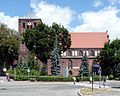
Marienkirche (15th and 19th centuries, renovated 1957–1973), Protestant until 1945.

Building of the medieval city fortifications (photo 1959)

Rest of the city walls from the 13th century

Half-timbered house from the 18th / 19th century century


.jpg)

With the Prussian administrative reorganization in 1816 Friedeberg became the district town of the district of the same name in the administrative district of Frankfurt in the province of Brandenburg . When building modern traffic routes, the city was initially only able to benefit from the Berlin – Königsberg state road , which it touched directly. The equally important stretch of the Eastern Railway ran seven kilometers to the south, and it was not until 1897 that the connection to the main railway network was created with the construction of the Friedeberger Kleinbahn. Even during the phase of industrialization at the end of the 19th century, Friedeberg was unable to shake off the character of an agricultural town, because only small businesses producing furniture, tiles and leather goods settled there.
When the province of Grenzmark Posen-West Prussia was dissolved in 1938 , Friedeberg and the district became part of the Pomerania province . On the eve of the Second World War , about 6,100 people lived in the city.
Towards the end of the Second World War, the Red Army took Friedeberg almost without a fight on January 29, 1945 and deliberately burned about 80 percent of the city. After the war ended, the city was placed under Polish administration. The residents were evicted by the local Polish administrative authority and replaced by Poles .
Ukrainians and Lemks who were forcibly resettled from the Beskids came to the newly settled Poles in 1947 as part of the Vistula action within Poland . They created their own cultural center in the former water tower to maintain their traditions. Friedberg was named Strzelce Krajeńskie in 1946. This name goes back to the Slavic name of the place, which already existed before the German settlement in the 13th century in the form of Strelci and means about place of archers .
Population development
- 1750: 2.051
- 1801: 2,496
- 1840: 4,290
- 1858: 5,371, including twelve Catholics and 219 Jews
- 1875: 5,804
- 1880: 6.381
- 1890: 6,431, including 84 Catholics and 196 Jews
- 1925: 5,591, including 120 Catholics and 44 Jews
- 1933: 6.134
- 1939: 5.923
Attractions
The three-aisled St. Mary's Church from the 13th century, burned down by the Hussites, was rebuilt in 1433 as a brick hall church and equipped with a star vault in the interior. In 1697 the tower was given a baroque tower. The interior and crowning of the tower burned down in February 1945 and the roof of the nave collapsed. Between 1971 and 1973 the church was rebuilt.
More than 1000 meters of the up to eight meters high field stone wall and the Gothic Driesener Tor (Młyńska) are still preserved from the medieval city fortifications .
Near the Driesener gate is a 1764-built brick granary .
The Berlin sculptor Steinemann created the war memorial in 1870/71 for the Friedeberg district, which was inaugurated in 1879. A Germania statue stood on the base .
sons and daughters of the town
- Karl Heinrich Pudor (1777–1839), classical philologist, high school teacher
- Theodor Hoffmann (1837–1894), German medical officer and university professor, also in Japan
- Ludwig Noster (1859–1910), German court portrait and genre painter
- Erich Wernicke (1859–1928), German physician
- Max Dennert (1861–1922), German sculptor
- Bruno Schulz (1865–1932), German architect and university professor
- Wilhelm Uhde (1874–1947), German art historian
- Georg Karg (1888–1972), German entrepreneur
- Hermann Kreutz (* 1931), German church musician
- Mariusz Gil (* 1983), Polish cyclocross rider
Personalities who have worked on site
- Hugo Prejawa (1854–1926), German archaeologist, architect and building inspector
Twin cities
Gmina Strzelce Krajeńskie
General
The urban and rural municipality Strzelce Krajeńskie is located in the extreme northeast of the Lubusz Voivodeship and has more than 17,000 inhabitants. Its municipality area is 318.57 km², so it takes 25.52% of the area of the Powiat Strzelecko-Drezdenecki ( Friedeberg-Driesen district ).
Neighboring communities are:
- Lubusz Voivodeship:
- Kłodawa ( Kladow ) and Santok ( Zantoch ) in the powiat Gorzowski ( Landsberg a. D. Warthe district ),
- Dobiegniew ( Woldenberg ), Stare Kurowo ( Altkarbe ) and Zwierzyn ( New Mecklenburg ) in the powiat Strzelecko-Drezdenecki,
-
West Pomeranian Voivodeship :
- Bierzwnik ( Marienwalde ), Krzęcin ( Kranzin ) and Pełczyce ( Bernstein ) in the powiat Choszczeński ( Arnswalde district ),
- Barlinek ( Berlinchen ) in the Powiat Myśliborski ( Soldin district ).
Community structure
- Districts ( sołectwo ):
|
- Other localities :
Buszewko ( Neumuehle F ), Chwytowo, Ciecierzyn ( Arendshof ) Czyżewo ( Voigtei ) Długie ( Dolgen ) Golczewice ( Marienland ), Male Osiedle, Ogardzki Młyn ( Wugartener mill ), Piastowo ( Bachmannshof ) Pieńkowice, Puszczykowo ( Käuzchenberg ) Sródlesie ( barrel spring ), Tuczenko and Wilanów ( Wildenower forestry ).
traffic
Streets
Strzelce Krajeńskie is located on the important Polish national road 22 , which leads from the German border at Kostrzyn nad Odrą ( Küstrin ) to Grzechotki ( Rehfeld ) on the border with Russia . Almost its entire course corresponds to the former German Reichsstrasse 1 , which reached from Aachen via Berlin and Königsberg (Prussia) to Eydtkuhnen .
In Strzelce Krajeńskie it crosses the voivodship road 156 , which runs south from Lipiany ( Lippehne ) to Drezdenko ( Driesen ).
rails
The PKP line 203 runs through the municipality from Kostrzyn nad Odrą ( Küstrin ) to Tczew ( Dirschau ). It is the route of the former Prussian Eastern Railway from Berlin to Königsberg (Prussia) . The Strzelce Krajeńskie Wschód (east) station on this line (formerly Friedeberg (Neumark) ) is six kilometers south of the city. The Strzelce Krajeńskie railway station is located in the city and has not been in operation since the 1990s. Before 1945 this line of the Friedeberger Bahnen reached as far as Alt Libbehne (now Polish: Lubiana Pyrzycka).
Since March 20, 2016, individual trains of the RB 26 of the Niederbarnimer Eisenbahn have been running from Küstrin via Landsberg (Warthe) to Kreuz (Ostbahn) . These journeys are carried out in cooperation with Przewozy Regionalne and Arriva Poland by DB Regio with a DB class 628 multiple unit.
literature
- W. Riehl and J. Scheu (eds.): Berlin and the Mark Brandenburg with the Margraviate Nieder-Lausitz in their history and in their present existence . Berlin 1861, pp. 455-456.
- Heinrich Berghaus : Land book of the Mark Brandenburg and the Markgrafthum Nieder-Lausitz , Volume 3, Brandenburg 1856, pp. 469-472.
- Paweł Rutkowski: Forays between the Oder and Drage . German Cultural Forum for Eastern Europe , Potsdam 2012, ISBN 978-3-936168-44-0 , pp. 185–189.
- Johannes Schultze : Friedeberg . In: Gerd Heinrich (Hrsg.): Handbook of the historical sites of Germany . Volume 10: Berlin and Brandenburg (= Kröner's pocket edition . Volume 311). Kröner, Stuttgart 1973, ISBN 3-520-31101-1 , pp. 431-433.
Web links
- Official website of the city (Polish)
- Information and photos about the city
- Gunthard Stübs and Pomeranian Research Association: The city of Friedeberg Nm. in the former Friedeberg district in Pomerania (2011)
- Strzelce Krajeńskie - Hill of Peace in Neumark - History of a City (PDF file; 6.24 MB)
Individual evidence
- ↑ a b population. Size and Structure by Territorial Division. As of June 30, 2019. Główny Urząd Statystyczny (GUS) (PDF files; 0.99 MiB), accessed December 24, 2019 .
- ^ Website of the municipality, Burmistrz , accessed on March 13, 2015
- ↑ a b c d e f Riehl and Scheu (1861), pp. 455–456.
- ^ Paweł Rutkowski: Forays between Oder and Drage . German Cultural Forum Eastern Europe, Potsdam 2012, ISBN 978-3-936168-44-0 , pp. 188f.
- ^ City history of Strzelce Krajeńskie
- ↑ a b c d e Michael Rademacher: German administrative history from the unification of the empire in 1871 to the reunification in 1990. Landkreis Friedeberg (Polish Strzelce Krajenskie). (Online material for the dissertation, Osnabrück 2006).
- ↑ http://stadt.friedeberg.kreis-friedeberg.de/