Tczew – Küstrin – Kietz border line
| Tczew – Küstrin-Kietz | |||||||||||||||||||||||||||||||||||||||||||||||||||||||||||||||||||||||||||||||||||||||||||||||||||||||||||||||||||||||||||||||||||||||||||||||||||||||||||||||||||||||||||||||||||||||||||||||||||||||||||||||||||||||||||||||||||||||||||||||||||||||||||||||||||||||||||||||||||||||||||||||||||||||||||||||||||||||||||||||||||||||||||||||||||||||||||||||||||||||||||||||||||||||||||||||||||||||||||||||||||||||||||||||||||||||||||||||||||||||||||||||||||||||||||||||||||||||||||||||||||||||||||||||||||||||||||||||||||||||||||||||||||||||||||||||||||||||||||||||||||||||||||||||||||||||||||||||||||||||||||||||||||||||||||||||||||||||||||||||||||||||||||||||||||||||||
|---|---|---|---|---|---|---|---|---|---|---|---|---|---|---|---|---|---|---|---|---|---|---|---|---|---|---|---|---|---|---|---|---|---|---|---|---|---|---|---|---|---|---|---|---|---|---|---|---|---|---|---|---|---|---|---|---|---|---|---|---|---|---|---|---|---|---|---|---|---|---|---|---|---|---|---|---|---|---|---|---|---|---|---|---|---|---|---|---|---|---|---|---|---|---|---|---|---|---|---|---|---|---|---|---|---|---|---|---|---|---|---|---|---|---|---|---|---|---|---|---|---|---|---|---|---|---|---|---|---|---|---|---|---|---|---|---|---|---|---|---|---|---|---|---|---|---|---|---|---|---|---|---|---|---|---|---|---|---|---|---|---|---|---|---|---|---|---|---|---|---|---|---|---|---|---|---|---|---|---|---|---|---|---|---|---|---|---|---|---|---|---|---|---|---|---|---|---|---|---|---|---|---|---|---|---|---|---|---|---|---|---|---|---|---|---|---|---|---|---|---|---|---|---|---|---|---|---|---|---|---|---|---|---|---|---|---|---|---|---|---|---|---|---|---|---|---|---|---|---|---|---|---|---|---|---|---|---|---|---|---|---|---|---|---|---|---|---|---|---|---|---|---|---|---|---|---|---|---|---|---|---|---|---|---|---|---|---|---|---|---|---|---|---|---|---|---|---|---|---|---|---|---|---|---|---|---|---|---|---|---|---|---|---|---|---|---|---|---|---|---|---|---|---|---|---|---|---|---|---|---|---|---|---|---|---|---|---|---|---|---|---|---|---|---|---|---|---|---|---|---|---|---|---|---|---|---|---|---|---|---|---|---|---|---|---|---|---|---|---|---|---|---|---|---|---|---|---|---|---|---|---|---|---|---|---|---|---|---|---|---|---|---|---|---|---|---|---|---|---|---|---|---|---|---|---|---|---|---|---|---|---|---|---|---|---|---|---|---|---|---|---|---|---|---|---|---|---|---|---|---|---|---|---|---|---|---|---|---|---|---|---|---|---|---|---|---|---|---|---|---|---|---|---|---|---|---|---|---|---|---|---|---|---|---|---|---|---|---|---|---|---|---|---|---|---|---|---|---|---|---|---|---|---|---|---|---|---|---|---|---|---|---|---|---|---|---|---|---|---|---|---|---|---|---|---|---|---|---|---|---|---|---|---|---|---|---|---|---|---|---|---|---|---|---|---|---|---|---|---|---|---|---|---|---|---|---|---|---|---|---|---|---|---|---|---|---|---|---|---|---|---|---|---|---|---|---|---|---|---|---|---|---|---|---|---|---|---|---|---|---|---|---|---|---|---|---|---|---|---|---|---|---|---|---|---|---|---|---|---|---|---|---|---|---|---|---|---|---|---|---|---|---|---|---|---|---|---|---|---|---|---|---|---|---|---|---|---|---|---|---|---|---|---|---|---|---|---|---|---|---|---|---|---|---|---|---|---|---|---|---|---|---|---|---|---|---|---|---|---|---|---|---|---|---|---|---|---|---|---|---|---|---|---|---|---|
|
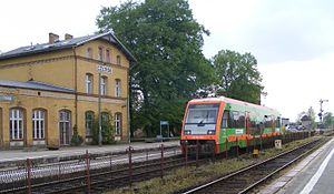
Czersk railway station
| |||||||||||||||||||||||||||||||||||||||||||||||||||||||||||||||||||||||||||||||||||||||||||||||||||||||||||||||||||||||||||||||||||||||||||||||||||||||||||||||||||||||||||||||||||||||||||||||||||||||||||||||||||||||||||||||||||||||||||||||||||||||||||||||||||||||||||||||||||||||||||||||||||||||||||||||||||||||||||||||||||||||||||||||||||||||||||||||||||||||||||||||||||||||||||||||||||||||||||||||||||||||||||||||||||||||||||||||||||||||||||||||||||||||||||||||||||||||||||||||||||||||||||||||||||||||||||||||||||||||||||||||||||||||||||||||||||||||||||||||||||||||||||||||||||||||||||||||||||||||||||||||||||||||||||||||||||||||||||||||||||||||||||||||||||||||||
| Route number : | 203 | ||||||||||||||||||||||||||||||||||||||||||||||||||||||||||||||||||||||||||||||||||||||||||||||||||||||||||||||||||||||||||||||||||||||||||||||||||||||||||||||||||||||||||||||||||||||||||||||||||||||||||||||||||||||||||||||||||||||||||||||||||||||||||||||||||||||||||||||||||||||||||||||||||||||||||||||||||||||||||||||||||||||||||||||||||||||||||||||||||||||||||||||||||||||||||||||||||||||||||||||||||||||||||||||||||||||||||||||||||||||||||||||||||||||||||||||||||||||||||||||||||||||||||||||||||||||||||||||||||||||||||||||||||||||||||||||||||||||||||||||||||||||||||||||||||||||||||||||||||||||||||||||||||||||||||||||||||||||||||||||||||||||||||||||||||||||||
| Course book range : | 426 Tczew – Piła Główna, 345 Piła Główna– Küstrin-Kietz |
||||||||||||||||||||||||||||||||||||||||||||||||||||||||||||||||||||||||||||||||||||||||||||||||||||||||||||||||||||||||||||||||||||||||||||||||||||||||||||||||||||||||||||||||||||||||||||||||||||||||||||||||||||||||||||||||||||||||||||||||||||||||||||||||||||||||||||||||||||||||||||||||||||||||||||||||||||||||||||||||||||||||||||||||||||||||||||||||||||||||||||||||||||||||||||||||||||||||||||||||||||||||||||||||||||||||||||||||||||||||||||||||||||||||||||||||||||||||||||||||||||||||||||||||||||||||||||||||||||||||||||||||||||||||||||||||||||||||||||||||||||||||||||||||||||||||||||||||||||||||||||||||||||||||||||||||||||||||||||||||||||||||||||||||||||||||
| Route length: | 342.453 km | ||||||||||||||||||||||||||||||||||||||||||||||||||||||||||||||||||||||||||||||||||||||||||||||||||||||||||||||||||||||||||||||||||||||||||||||||||||||||||||||||||||||||||||||||||||||||||||||||||||||||||||||||||||||||||||||||||||||||||||||||||||||||||||||||||||||||||||||||||||||||||||||||||||||||||||||||||||||||||||||||||||||||||||||||||||||||||||||||||||||||||||||||||||||||||||||||||||||||||||||||||||||||||||||||||||||||||||||||||||||||||||||||||||||||||||||||||||||||||||||||||||||||||||||||||||||||||||||||||||||||||||||||||||||||||||||||||||||||||||||||||||||||||||||||||||||||||||||||||||||||||||||||||||||||||||||||||||||||||||||||||||||||||||||||||||||||
| Gauge : | 1435 mm ( standard gauge ) | ||||||||||||||||||||||||||||||||||||||||||||||||||||||||||||||||||||||||||||||||||||||||||||||||||||||||||||||||||||||||||||||||||||||||||||||||||||||||||||||||||||||||||||||||||||||||||||||||||||||||||||||||||||||||||||||||||||||||||||||||||||||||||||||||||||||||||||||||||||||||||||||||||||||||||||||||||||||||||||||||||||||||||||||||||||||||||||||||||||||||||||||||||||||||||||||||||||||||||||||||||||||||||||||||||||||||||||||||||||||||||||||||||||||||||||||||||||||||||||||||||||||||||||||||||||||||||||||||||||||||||||||||||||||||||||||||||||||||||||||||||||||||||||||||||||||||||||||||||||||||||||||||||||||||||||||||||||||||||||||||||||||||||||||||||||||||
| Top speed: | 120 km / h | ||||||||||||||||||||||||||||||||||||||||||||||||||||||||||||||||||||||||||||||||||||||||||||||||||||||||||||||||||||||||||||||||||||||||||||||||||||||||||||||||||||||||||||||||||||||||||||||||||||||||||||||||||||||||||||||||||||||||||||||||||||||||||||||||||||||||||||||||||||||||||||||||||||||||||||||||||||||||||||||||||||||||||||||||||||||||||||||||||||||||||||||||||||||||||||||||||||||||||||||||||||||||||||||||||||||||||||||||||||||||||||||||||||||||||||||||||||||||||||||||||||||||||||||||||||||||||||||||||||||||||||||||||||||||||||||||||||||||||||||||||||||||||||||||||||||||||||||||||||||||||||||||||||||||||||||||||||||||||||||||||||||||||||||||||||||||
| Dual track : | Tczew – Gutowiec; Piła Główna – Wawrów; Gorzów Wielkopolski – Kostrzyn |
||||||||||||||||||||||||||||||||||||||||||||||||||||||||||||||||||||||||||||||||||||||||||||||||||||||||||||||||||||||||||||||||||||||||||||||||||||||||||||||||||||||||||||||||||||||||||||||||||||||||||||||||||||||||||||||||||||||||||||||||||||||||||||||||||||||||||||||||||||||||||||||||||||||||||||||||||||||||||||||||||||||||||||||||||||||||||||||||||||||||||||||||||||||||||||||||||||||||||||||||||||||||||||||||||||||||||||||||||||||||||||||||||||||||||||||||||||||||||||||||||||||||||||||||||||||||||||||||||||||||||||||||||||||||||||||||||||||||||||||||||||||||||||||||||||||||||||||||||||||||||||||||||||||||||||||||||||||||||||||||||||||||||||||||||||||||
|
|||||||||||||||||||||||||||||||||||||||||||||||||||||||||||||||||||||||||||||||||||||||||||||||||||||||||||||||||||||||||||||||||||||||||||||||||||||||||||||||||||||||||||||||||||||||||||||||||||||||||||||||||||||||||||||||||||||||||||||||||||||||||||||||||||||||||||||||||||||||||||||||||||||||||||||||||||||||||||||||||||||||||||||||||||||||||||||||||||||||||||||||||||||||||||||||||||||||||||||||||||||||||||||||||||||||||||||||||||||||||||||||||||||||||||||||||||||||||||||||||||||||||||||||||||||||||||||||||||||||||||||||||||||||||||||||||||||||||||||||||||||||||||||||||||||||||||||||||||||||||||||||||||||||||||||||||||||||||||||||||||||||||||||||||||||||||
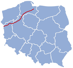
The Tczew – German border (–Küstrin-Kietz) railway is a partially, formerly continuously double-track and non-electrified railway line in the Polish voivodeships of Pomerania , Greater Poland and Lebus . It has largely lost the importance it had as part of the Royal Prussian Eastern Railway .
course
The route begins at the Tczew (Dirschau) long-distance train station , which is on the Warszawa – Gdańsk railway line and is the end of the Chorzów – Tczew railway , the coal main line . From there it runs southwest to the next long-distance train station, Starogard Gdański (Prussian Stargard; km 23.972), where it crosses the Skórcz – Skarszewy (Skurz – Schöneck) railway, which is only operated a little further south in freight traffic . The route continues via the long-distance train stations Kaliska (Dreidorf; km 46.926), Czarna Woda (Königswiese; km 56.106) and Czersk (km 66.983), where it crosses the Laskowice Pomorskie – Bąk railway line, which is no longer in service to the north , after the Chojnice junction (Konitz; km 96.227), the end point of the Działdowo – Chojnice (Soldau – Konitz) railway and the Oleśnica – Chojnice (Oels – Konitz) railway line, which is no longer operated here, and the beginning of the Chojnice – Runowo Pomorskie and Chojnice – Kościerzyna railway . The route continues via the nearest long-distance train stations Złotów (Flatow) - the end point of the disused railway line Świecie nad Wisłą – Złotów and the railway line Deutsch Krone – Flatow , which has been closed since 1945 - and Krajenka (Krojanke; km 156.031) to Piła Główna (Schneidemühl; km 179.542 ), a hub for many routes, see route diagram on the right. The nearest long-distance train station is Trczianka (Schönlanke; km 202.073), followed by Krzyż (cross; km 237.939), where the line crosses the Poznań – Szczecin railway line . The Stare Bielice – Skwierzyna railway once branched off at the stop, formerly a train station, Stare Bielice (Altbeelitz; km 244.940) . The next long-distance train station is Nowe Drezdenko (Driesen-Vordamm; km 251.027), then Strzelce Krajeńskie Wschód (Friedeberg (Neum.); Km 268.223), where the route of the former Friedeberger Bahnen branched off. The next and last long-distance train station on the route is Gorzów Wielkopolski (Landsberg (Warthe); km 297.101) - the start of the Gorzów Wielkopolski – Zbąszynek railway and the disused Gorzów Wielkopolski – Myślibórz railway . The route continues via Kostrzyn (Cüstrin N. Hbf / Küstrin N Hbf; km 340.362) - tower station with the Wrocław – Szczecin railway and the end point of the Grzmiąca – Kostrzyn railway, which is only partially used by freight, to the German border on the Oder .
For passenger trains (hauled by a locomotive or with multiple units) the maximum speed between Tczew and Chojnice is 100 km / h, between Chojnice and the voivodship border at Lipka Krajeńska at 90 km / h, between the voivodeship border and the German border and Kostrzyn almost 100 km / h h, up to the state border at 80 km / h, railcars may run between Gorzów Wielkopolski and Kostrzyn at 120 km / h, then at 100 km / h; For freight trains, the maximum speed between Tczew and Chojnice is 100 km / h, between Chojnice and the voivodship border at Lipka Krajeńska it is 50 km / h, and up to the German border it is largely 70 km / h.
history
The first section of today's route was the Schneidemühl - Lugatz (later cross) section opened on July 27, 1851 , connected with the Bromberg –Schneidemühl section of today's Kutno – Piła railway line . A connection to the Prussian capital Berlin existed only with a major detour via the Posen – Stettin line opened in 1846–1848 and the Stettin – Berlin line opened in 1842–1843 . In 1851 the Posen – Stettin line was nationalized, while the Stettin – Berlin line remained in private hands until 1880. With the opening of the Lugatz - Landsberg an der Warthe - Küstrin - Küstrin-Kietz - Frankfurt (Oder) route on October 12, 1857, the detour was shortened, until 1867 with the opening of the direct Küstrin-Kietz - Berlin route again. In the direction of Danzig and Königsberg (East Prussia) , however, a detour via Bromberg was still necessary. This changed in 1871–1873: on January 16, 1871 the sections Dirschau - Preußisch Stargard and Flatow (West Prussia) –Schneidemühl were opened, on November 15, 1871 the section Konitz –Flatow (West Prussia), on April 15, 1873 the Prussian Stargard - Hochstüblau and the gap closure Hochstüblau-Konitz was put into operation on August 15, 1873; the rest of the line had previously been expanded to double tracks. The sections opened in the 1870s soon followed.
As part of the Royal Prussian Eastern Railway, the route was one of the most important routes in the German Empire , which was founded on January 18, 1871. The 1914 summer timetable provided for seven to nine pairs of express trains, including the northern express, depending on the section . According to the Versailles Treaty , the route began on Polish territory from 1920, and corridor traffic was set up for through traffic to and from East Prussia . With this, and even more so with the end of World War II and the annexation of the German eastern territories to Poland and the Soviet Union, the importance of the route sank sharply. The second track was dismantled on several lines, long-distance traffic was only operated in the Piła Główna – Gorzów Wielkopolski section until December 2016. In the 2017 annual timetable, a pair of TLK trains called “Kociewie”, which means the resumption of long-distance traffic between Tczew and Piła.
In mid-2018, the entire route between the Gorzów Wielkopolski and Gorzów Wielkopolski Wschodni stations as well as the associated Gorzów Wielkopolski station section was closed due to the complete overhaul of the Gorzów Wielkopolski elevated viaduct .
Train accidents
On October 8, 1916 the railway accident in Landsberg (Warthe) occurred with twelve dead and fifteen injured, on July 30, 1918 the railway accident in Zantoch with at least 40 deaths and 43 injured, and on September 11, 1918 the railway accident in Schneidemühl with 35 deaths and 18 injured and on May 1, 1925 the railway accident in Starogard Gdański with 29 dead and dozens injured.
Literature and web links
- Ryszard Stankiewicz and Marcin Stiasny: Atlas Linii Kolejowych Polski 2014 . Eurosprinter, Rybnik 2014, ISBN 978-83-63652-12-8 , pp. B5–7, C2–5, D1–2
- Description on atlaskolejowy.net (Polish)
- Description on bazakolejowa.pl (Polish)
Remarks
- ↑ Kursbuch 1914 does not know it, Kursbuch 1917 knows it.
- ↑ a b c According to Ryszard Stankiewicz and Marcin Stiasny: Atlas Linii Kolejowych Polski 2014 . Eurosprinter, Rybnik 2014, ISBN 978-83-63652-12-8 .
- ^ No later than 1914 according to the course book.
- ↑ PKP Polskie Linie Kolejowe : Maximum speeds for wagon trains , multiple units and freight trains from April 10, 2018.
- ↑ Empire Kursbuch July 1914 reprint, 5th Edition, 1995, Ritzau KG - Publisher time and railways, Pürgen, ISBN 3-921 304-09-1 .

