
Złotów
| Złotów | |||
|---|---|---|---|

|
|
||
| Basic data | |||
| State : | Poland | ||
| Voivodeship : | Greater Poland | ||
| Powiat : | Złotów | ||
| Area : | 11.58 km² | ||
| Geographic location : | 53 ° 22 ' N , 17 ° 2' E | ||
| Height : | 110 m npm | ||
| Residents : | 18,498 (June 30, 2019) |
||
| Postal code : | 77-400 | ||
| Telephone code : | (+48) 67 | ||
| License plate : | PZL | ||
| Economy and Transport | |||
| Street : | Ext. 188 : Piła - Debrzno - Człuchów | ||
| Ext. 189 : Jastrowie –Więcbork | |||
| Rail route : | PKP line 203: Kostrzyn nad Odrą – Tczew | ||
| Next international airport : | Poznań-Ławica | ||
| Gmina | |||
| Gminatype: | Borough | ||
| Residents: | 18,498 (June 30, 2019) |
||
| Community number ( GUS ): | 3031011 | ||
| Administration (as of 2020) | |||
| Mayor : | Adam Pulit | ||
| Address: | al. Piasta 1 77-400 PLN |
||
| Website : | www.zlotow.eu | ||

Złotów [ 'zwɔtuf ] ( German Flatow ) is a city in the Greater Poland Voivodeship in Poland . The surrounding Gmina Złotów has its seat in the town.
Geographical location

The city was historically in the north of Greater Poland , but in the German Empire in the west of West Prussia . It is located on the left bank of the Głomia River (Glumia), about 30 kilometers northeast of the city of Piła (Schneidemühl) and 110 kilometers north of the city of Poznań ( Posen ). There are several lakes in their vicinity.
history


Remains of a castle rampart from around 700 AD were found on the banks of the Babbensee. It is believed that a tribal chief had his seat here.
From the middle of the 12th century, the Samborids ruled the land west of the lower Vistula. It is not exactly known to what extent their territory, after Tczew / Dirschau, the headquarters of the dukes, known as Land Dirsova, extended south. This ducal house died out in 1294. The Order's rule did not extend that far south.
In the year it was first mentioned in 1370, Flatow was referred to as a city called Velatow or Wielatow , according to Magdeburg law and under Polish rule (for comparison: In Danzig, Lübisches law was valid under the Samborids , and Kulmer law under the Teutonic Order ). For a short time, the Polish king Casimir III. his grandson, Duke Casimir IV of Pomerania-Stolp , fiefdomed the city around 1375. On the other hand, it already belonged to the Kalisz Voivodeship , which had been established in the first half of the century.
In 1532 Flatow, which in the meantime had become the rulers' media town , received (again?) Market rights. In 1619, the Catholic parish of the Assumption of Mary was founded with a document signed by Jan Potulicki . She received, among other things, new Hufen land and 3,000 guilders. However, the towerless church was only built in 1660 by its city lord Andreas Grundinski. A Protestant church had existed since the Reformation , it was destroyed during the Thirty Years War , but rebuilt in 1652. During the Polish-Swedish War in 1657 Flatow Castle was attacked by the Swedes. Parts of the city, including the town hall, were also destroyed by the shelling. After the Grudzinski family died out in 1688, the Dzialynscys took over the town.
Flatow was also ravaged by the plague during 1709 and 1711 . The epidemic fell victim to 1650 inhabitants. In order to reconcile with the angry God, a chapel dedicated to Saint Rochus was built in the cemetery. During the Northern War , Russian troops marched through the city in 1717 and 1718. In 1734 the city was destroyed by Russian troops during the War of the Polish Succession .
In the course of the First Partition of Poland , Flatow came to Prussia in 1772 and was assigned to the network district . The city had meanwhile developed into an economically strong brewery and drapery center, with the trade being entirely in Jewish hands. In 1788 rulership changed again after Johann von Farenfeld had acquired it. Ten years later, he sold the city to Johann Karl von Gerhardt.
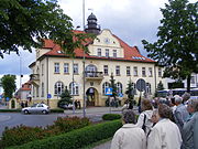
town hall

Street train

Local museum
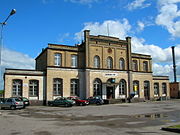
railway station


In 1803 there was the last big fire in the city, after several similar catastrophes in the 17th and 18th centuries. With the introduction of a new Prussian territorial administration, Flatow became the district town of the Flatow district in 1818 and was now in the province of West Prussia . In 1820 the Prussian royal family acquired the city for 800,000 thalers, stipulating that the king's oldest relative should exercise the property rights.
At the instigation of King Friedrich Wilhelm III. received Peter Joseph Lenné to design the city plants commissioned, and Carl Friedrich Schinkel was commissioned to create the design for a new Protestant church. This church became the official seat of a superintendent , whose diocese (church district) was part of the old Prussian church province of West Prussia .
From 1871 Flatow developed into a railway junction. The brewery founded by Franz Welsch in 1881, which developed into one of the largest in West Prussia, also belonged to the industry that developed. In 1907 she was awarded the title of "Royal Court Supplier". In 1912, the water tower, a landmark of the city that still exists today, was built.
As a result of the Versailles Treaty , two fifths of the Flatow district had to be surrendered to Poland in 1919 , but the city of Flatow remained with Germany despite violent protests by the Polish minority. It was incorporated into the newly created province of Grenzmark Posen-West Prussia . When this was dissolved again in 1938, Flatow came to the province of Pomerania .
On June 21, 1924, the Reichsgericht confirmed the property rights of the Prussian Prince Friedrich Leopold to Flatow and thus made an important decision in principle on the compensation claims of the German nobility in the Weimar Republic .
Towards the end of the Second World War , the Red Army occupied the region in the spring of 1945 . According to Polish sources, a Polish infantry regiment of the Soviet Army had participated in the capture of Flatow . A third of the city was destroyed, mainly in the center.
In the summer of 1945 Flatow was placed under Polish administration by the Soviet occupying power in accordance with the Potsdam Agreement, along with all of Western Pomerania, all of West Prussia and the southern half of East Prussia . The place name Złotów was introduced for Flatow in June 1945 . The immigration of Polish civilians began. In the following time the residents were evicted from Flatow by the local Polish administration . The last remaining German residents were expelled in 1946 or had to take on Polish citizenship.
New Polish-speaking schools were opened as early as June 1945. In 1975 the city lost its county seat status, which it only regained in 1999. In 1977 the “METALPLAST” plant started operations, which has developed into one of the most important industrial locations in the region. In 2003, the renovation of the old town began, with which the most important streets got their original character back.
Demographics
| year | Residents | Remarks |
|---|---|---|
| 1783 | 1,597 | including around 600 Protestants, 300 Catholics and 714 Jews |
| 1805 | 1,764 | thereof 1,058 Christians and 705 Jews |
| 1816 | 1,467 | 616 Protestants, 439 Catholics and 412 Jews |
| 1822 | 1,853 | 831 Protestants, 557 Catholics and 465 Jews |
| 1831 | 1,960 | including many Jews |
| 1849 | 2,841 | |
| 1852 | 2,772 | 1,421 Protestants, 742 Catholics and 609 Jews |
| 1864 | 3,172 | 1,644 Protestants, 903 Catholics and 535 Jews |
| 1871 | 3,311 | including 1,700 Evangelicals and 1,050 Catholics (730 Poles ) |
| 1875 | 3,510 | |
| 1880 | 3,921 | |
| 1890 | 3,852 | thereof 2,082 Evangelicals, 1,368 Catholics and 402 Jews (800 Poles ) |
| 1900 | 4.018 | mostly evangelicals |
| 1925 | 5,939 | of which 3,555 Protestants, 2,105 Catholics and 211 Jews |
| 1933 | 7.112 | |
| 1939 | 7,496 |
| year | Residents | Remarks |
|---|---|---|
| 2012 | 18,754 |
traffic
The voivodeship road DW188 leads to the towns of Człuchów (Schlochau) in the north and Piła (Schneidemühl) in the south.
From the local bus station there are long-distance buses to Bydgoszcz (Bromberg), Warsaw via Toruń and Koszalin via Szczecinek (Neustettin). Wałcz (Deutsch Krone), Debrzno (Preussisch Friedland), Jastrowie , Chojnice (Konitz), Człuchów and Piła are regularly served in local transport .
Złotów is located on the route of the former Prussian Eastern Railway from Berlin via Malbork (Marienburg) to Kaliningrad . On this railway line run today from Chojnice to Piła and also on to Krzyż Wielkopolski ( Kreuz ) regional trains of the Przewozy Regionalne . The Świecie nad Wisłą – Złotów railway and the Deutsch Krone – Flatow railway, which was closed in 1945, have been closed .
Town twinning
Złotów has partnerships with six municipalities:
- Eggesin , Germany
- Goole , United Kingdom
- Nyasvish , Belarus
- Rathenow , Germany
- District of Gifhorn , Germany - the district is at the same time the godfather of the former German district of Flatow and partner of the new Polish powiat Złotów
- La Flèche , France
Personalities
sons and daughters of the town
- Adolf von Gerhardt (1803–1879), Prussian administrative lawyer
- Nahida Sturmhöfel (1822–1889), German poet and champion in the field of women
- Friedrich Wiebe (1829–1882), German railroad builder
- Theodor Jankowski (1852-1919), Polish Catholic clergyman and member of the German Reichstag
- Ottomar Weymann (1853–1909), German painter
- Walter Körte (1855–1914), German hydraulic engineer
- Werner von Weiher (1859–1904), German administrative officer
- Arthur Cohn (1862–1926), rabbi
- Emil Kahnemann (1871–1930), German chemist
- Walter Krueger (1881–1967), American four-star general, commanding general of the US 6th Army in the Pacific War
- Albert Walter (1885–1980), German politician (USPD, KPD, DP) and trade unionist
- Wilhelm Dobbek (1888–1971), German educator
- Heinz Wolfgang Lorenz (1899 – unknown), SS-Obersturmführer, district administrator and district leader of the NSDAP, jointly responsible for the crimes in Piaśnica
- Hans Joachim Mallach (1924–2001), German forensic doctor
- Helmut T. Heinrich (1933–2017), German writer and translator
- Günter Kahlberg (1936–1997), German administrative lawyer
- Eberhard Schöler (* 1940), former German table tennis player, sports official
- Joachim Zdrenka (* 1952), Polish history professor
- Andrzej Kokowski (* 1953), Polish archaeologist
literature
- in order of appearance
- Johann Friedrich Goldbeck : Complete Topography of the Kingdom of Prussia , Volume 2, Marienwerder 1789, Part I, p. 99, No. 4), and Part II, p. 56.
- August Eduard Preuss : Prussian country and folklore or description of Prussia. A manual for primary school teachers in the province of Prussia, as well as for all friends of the fatherland . Bornträger Brothers, Königsberg 1835, p. 377, No. 6.
- Friedrich Wilhelm Ferdinand Schmitt : The Flatow district. Shown in all its relationships . Lambeck, Thorn 1867, pp. 245-250.
- Otto Goerke: Geography, Statistics and History of the Flatow District , 1899
- Ernst Bohn: History of the Flatow Church District in West Prussia, 1902
- Otto Goerke: The Flatow district. In geographical, natural history and historical relationships . District Committee, Thorn 1918 (2nd edition: Home District Committee for the Flatow District, Gifhorn 1981 (also contains: Manfred Vollack: The Flatower Land in the period from 1918 to 1945. )).
- Home book for the Flatow district, Grenzmark Posen-West Prussia, Pomerania province. 1971
- Wojciech Wrzesiński (Ed.): Ziemia Złotowska . Morskie, Gdańsk 1969.
Web links
- Gunthard Stübs and Pomeranian Research Association: The town of Flatow in the former Flatow district in Pomerania (2011).
- Borders in East Central Europe in the 19th and 20th centuries (extensive representation of the city and district of Flatow) (German, PDF file; 3.6 MB)
- Flatow (Zlotow), Flatow County, West Prussia (William Remus, 2006) (English)
- Official website of the city (Polish)
Footnotes
- ↑ a b population. Size and Structure by Territorial Division. As of June 30, 2019. Główny Urząd Statystyczny (GUS) (PDF files; 0.99 MiB), accessed December 24, 2019 .
- ↑ In 1923 the Protestant parish of Flatow came to the ecclesiastical province of Grenzmark Posen-West Prussia and when it was dissolved in 1941 it changed to the ecclesiastical province of Pomerania .
- ^ Johann Friedrich Goldbeck : Complete topography of the Kingdom of Prussia . Volume 2, Part I, Marienwerder 1789, pp. 99-100, No. 4).
- ^ Friedrich Wilhelm Ferdinand Schmitt : Topography of the Flatower circle . In: Prussian Provincial Papers , Other Series, Volume VII, Königsberg 1855, p. 116.
- ↑ Alexander August Mützell and Leopold Krug : New topographical-statistical-geographical dictionary of the Prussian state . Volume 5: T – Z , Halle 1823, pp. 378–379, item 671.
- ^ A b c Friedrich Wilhelm Ferdinand Schmitt : The Flatow district. Shown in all its relationships . Lambeck, Thorn 1867, p. 297.
- ^ August Eduard Preuss : Prussian country and folklore or description of Prussia. A manual for primary school teachers in the province of Prussia, as well as for all friends of the fatherland . Bornträger Brothers, Königsberg 1835, p. 377, No. 6.
- ^ Official Journal for the Marienwerder administrative region . Volume 43, No. 23 of June 8, 1853, p. 135.
- ^ Gustav Neumann: Geography of the Prussian State . 2nd edition, Volume 2, Berlin 1874, pp. 56-57, item 12.
- ↑ a b c d e Michael Rademacher: German administrative history from the unification of the empire in 1871 to the reunification in 1990. flatow.html. (Online material for the dissertation, Osnabrück 2006).
- ↑ meyers Big conversational lexicon . 6th edition, Volume 6, Leipzig and Vienna 1906, pp. 665–666.
- ↑ Gunthard Stübs and Pomeranian Research Association: The city of Flatow in the former Flatow district in Pomerania (2011)
- ↑ Twin Towns on zlotow.pl
