Ostravice (river)
|
Ostravice (German: Ostrawitz (a) , Polish Ostrawica ) |
||
|
Inflow area |
||
| Data | ||
| location | Czech Republic | |
| River system | Or | |
| Drain over | Or → Stettiner Haff | |
| origin | near Staré Hamry in the Moravian-Silesian Beskids through the confluence of the Bílá Ostravice and Černá Ostravice 49 ° 27 ′ 17 ″ N , 18 ° 28 ′ 3 ″ E |
|
| Source height | 521 m nm | |
| muzzle | near Hrušov am Landek in the Oder Coordinates: 49 ° 52 ′ 9 ″ N , 18 ° 16 ′ 51 ″ E 49 ° 52 ′ 9 ″ N , 18 ° 16 ′ 51 ″ E |
|
| Mouth height | 204 m nm | |
| Height difference | 317 m | |
| Bottom slope | 4.9 ‰ | |
| length | 65.1 km | |
| Catchment area | 826.8 km² | |
| Drain |
MQ |
15.5 m³ / s |
| Reservoirs flowed through | Šance dam | |
| Big cities | Ostrava | |
| Medium-sized cities | Frýdek-Místek | |
| Small towns | Ostravice , Frýdlant nad Ostravicí | |
|
Origin of the Ostravice near Staré Hamry |
||
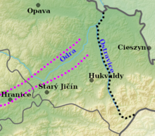
The Ostravice ( German : Ostrawitza , Polish Ostrawica ) is a right tributary of the Oder in Ostrava - Hrušov ( Czech Republic ). From the 13th century it forms the natural border between Moravia (left bank) and Silesia (right bank). The river is believed to be the namesake of the city of Ostrava. The catchment area is 826.8 km².
course
The Ostravice is created below the Příslop (782 m) near Althammer in the Moravian-Silesian Beskids through the confluence of two source rivers:
- Bílá Ostravice ( White Ostrawitza ) - rises on Vysoká and flows through Bílá
- Černá Ostravice ( Black Ostrawitza ) - rises on Grúň near Bílý Kříž
Shortly after its formation, the river flows through the Šance reservoir and continues in a north-westerly direction via Ostravice , Frýdlant nad Ostravicí and Frýdek-Místek , where the Morávka joins from the right . Behind Paskov , the Olešná flows into the Ostravice from the left and the Lučina in Slezská Ostrava from the right , before the Ostrawice flows into the Oder after 65 km at the Landek .
In the municipality of Ostravice, exposed rock formations can be observed along the river, which exemplify the geological composition and stratification of the Carpathian flysch zones. The site is often visited for excursions and has been a protected nature reserve since 1966 as the Koryto řeky Ostravice natural monument .
Border river

The Moravian-Silesian border along the Ostravice was initially regulated around the year 1260 (in literature, the border treaty was dated between 1256 and 1261) between Duke Wladislaus I of Opole-Ratibor and the Bohemian King Ottokar II the settlement of Arnold von Hückeswagen and Bruno von Schauenburg approached the Silesian settlements in the area. This was confirmed on August 2, 1297 between Mieszko I. von Teschen and Theodorich von Neuhaus . Two documents were issued on both sides, in which the area on the right bank was called Poland in Latin ( super metis et terminie apud Ostraviam in minibus buno rum ducatus nostri et episcopatus Olomucensis pro eo, quod fluvius idem qui de beret metas Polonie et Moravie distingire) , therefore z. B. Slezská Ostrava (Silesian Ostrava) was also named Polish Ostrava until 1919 , although the area between Ostravice and Lučina was inhabited by Moravian-speaking and non-Polish people, at least from the early modern period. The border lost its importance in 1327 when the Duchy of Teschen came under the sovereignty of the Crown of Bohemia, but the ecclesiastical border between the Diocese of Wroclaw and the Diocese of Olomouc existed on the Ostravice until 1978. On October 26, 1918, at a demonstration by tens of thousands of members of the Polish population in Teschen, a banner with the slogan “Wag, Ostrawica - Polska granica” ( Waag , Ostrawitz - Polish border) was blown. This became a sentimental revisionist slogan, but never became an official Polish claim to territory. The Polish National Council of the Duchy of Teschen renounced the Friedek district and it was not considered part of Zaolzie or the Olsa area when it was annexed in 1938.
Tributaries

- Červík (l), Šance dam
- Velký potok (l), Šance dam
- Jamník (r), Šance dam
- Poledňana (r), Šance dam
- Řečice (r), Šance dam
- Mazak (r)
- Bučací potok (l)
- Sepetný (r)
- Řasník (l)
- Čeladenka (l)
- Bílý potok (l)
- Frýdlantská Ondřejnice (l)
- Satina (r)
- Sibudov (r)
- Lubenec (r)
- Bystrý potok (r)
- Baštice (r)
- Morávka (r), Frýdek
- Podšajarka (r)
- Ostravická Datyňka (r)
- Olešná (l)
- Lučina (r), Slezská Ostrava
Web links
- River description (Czech)
- Information about the nature reserve (Czech)
Individual evidence
- ^ Idzi Panic: Śląsk Cieszyński w średniowieczu (do 1528) . Starostwo Powiatowe w Cieszynie, Cieszyn 2010, ISBN 978-83-926929-3-5 , p. 50 (Polish).
- ^ I. Panic, 2010, pp. 272, 400
- ^ Idzi Panic: Jak my ongiś godali. Język mieszkańców Górnego Śląska od średniowiecze do połowy XIX wieku [The language of the inhabitants of Upper Silesia in the Middle Ages and in modern times] . Avalon, Cieszyn-Kraków 2015, ISBN 978-83-7730-168-5 , p. 45 (Polish).
- ↑ K. Nowak, Śląsk Cieszyński w latach 1918–1945, 2015, p. 19

