Neuenhagen Island
| Neuenhagen Island | ||
|---|---|---|
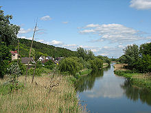
| View from the Oder to Neuenhagen Island | ||
| Waters | Or , old or | |
| Geographical location | 52 ° 49 ′ N , 14 ° 1 ′ E | |
|
|
||
| length | 12.6 km | |
| width | 6.4 km | |
| surface | 60 km² | |
| Highest elevation | 90.9 m | |
| main place | Neuenhagen | |
| The Neuenhagener Insel ("Neuenhagener Oderinsel") in the northern Oderbruch (approx. 1940). | ||
The island of Neuenhagen , also called Neuenhagener Oderinsel , Neuenhagener Insel or just Oderinsel , is a highland in the northern Oderbruch . It rises to about 90 m above the Oderbruch and is about 25 km² in size. In the west it is surrounded by old arms of the Oder and in the east by the breakthrough of the Oder (between Güstebiese / Gozdowice and Hohensaaten ). The New Oder, created with the breakthrough, is the state border with Poland .
The Oderinsel is located in the northeast of the Brandenburg district of Märkisch-Oderland between the towns of Oderberg and Bad Freienwalde .
Surname
The name "Insel Neuenhagen" , derived from the main town in the center of the landscape, is more recent. Probably a long time passed since the "island status" was achieved in 1753 until the "Neuenhagen Office" became the "Neuenhagen Island" . It was not until 1972 that the five villages joined together to form the community association of the same name.
geography
The island of Neuenhagen was originally a peninsula , a spur that, starting from the steep Polish bank of the Oder, extends over 6 km to the west. However, the current course of the Oder makes it an island again, the Neuenhagener Insel is completely surrounded by rivers today and was this also in the last Ice Age. Originally the Oder flowed around the peninsula in a meandering shape, so that two loops of the river (today the Stille Oder and the Old Oder ) came together to within 4.5 km. At this point, the Oder Canal was built from 1747 to 1753, which shortened the course of the river by 25 km and made the peninsula an island. The island of Neuenhagen is flat in the north and rises to the south. There are north of Schiffmühle with 90.9 m and northeast of Neutornow with the granite mountain of 75.1 m, the highest points on the island. The Oder, on the other hand, flows almost at sea level.
In addition to the districts of the municipality of Bad Freienwalde (Oder) ( Neuenhagen , Schiffmühle , Bralitz , Hohenwutzen and Altglietzen ), the southernmost part of the city of Oderberg, located to the right of the Old Oder , also belongs to the island.
The Neuenhagener Insel is covered by pine forest, especially on the poor soils in the west and south, while the central part is used for agriculture.
geology

The island of Neuenhagen is the product of all three known cold ages of the last ice age . The extensive clay deposits can be traced back to an ice reservoir at the end of the Saale cold period. The mountainous part in the south of the island is part of a terminal moraine that was formed in the course of the Pomeranian ice advance about 15,000 years ago and can be traced across northeast Brandenburg.
The Oder, which was blocked in its pre- glacial course at the time due to the glacier ice , turned to the west on Neuenhagener Insel and flowed as part of the glacial stream through the Eberswalde glacial valley into the Elbe . The slopes eroded by the flowing water can still be seen today. When the Oder finally turned north 2000 years later, today's sand and gravel deposits were deposited in the northwest of the island.
history
Finds show that the area around today's Oderberg was inhabited as early as the Mesolithic (8000 years ago). For the Neolithic Age (5500 to 3700 years ago) arable farming and animal husbandry could be proven. There was particularly dense settlement in the Bronze Age and Pre-Roman Iron Age , while during the Migration Period only a weaker Germanic , probably Burgundian, settlement was noticeable. The island was inhabited by Slavs from 600 AD . As part of the German eastward expansion which was created in 1200 askanische castle of Oderberg and the castle Finow . Oderberg is said to be the successor to the even older Slavic Barsdyn. But it is also possible that Barsdyn means the nearby Parstein .
In 1337, a Nicolaus Witte from the Burgmann family of Zehden (today Cedynia) is mentioned in the Neumark land register who owned the four Slavic villages Glizen, Gralitzen, Grabow and Botzow (Glietzen, Bralitz , Gabow and Hohenwutzen ) and the Fährkrug (after Oderberg) owns. Since the peninsula at that time was already part of the Neumark (officially "Neumark" since 1397), the importance of the ferry crossing is to be assessed as very high. To protect the road that crosses the Oder here, Margrave Ludwig the Roman had another fortress built across from Oderberg (today's Bärenkasten castle ruins ) in 1353–1355 . In the second half of the 13th century, Nienhof (Neuenhof, later Neuenhagen ) was finally a German manor. Only a little later, the ship mill , which gave the later village its name, can also be expected; the village itself was not mentioned until 1753.
Later owners of the villages on the island were the Brederlows and in 1350 those of Mörner zu Mohrin , who presumably administered the fiefdom for a still underage Uchtenhagen. The von Uchtenhagen family, who formerly came from the Altmark , already had possessions in Biesenthal until it was proven in 1480 with Caspar von Uchtenhagen and his nephew in Neuenhagen. Around 1575, the Neuenhagen manor was converted into a “permanent house”, that is, in a castle-like manner (the main building now houses a kindergarten ).
In 1604 the reign of Neuenhagen was sold to the elector for 25,000 thalers. Neuenhagen became the electoral office. In 1613 the elector gave the office with all serfs to his wife. The Swedes devastated the country in the Thirty Years War . The population was decimated by the plague in 1630/31 and by a great famine in 1639 . In 1659 half of all fishing and peasant farms were vacant or desolate.

In 1747 the construction of the new Oder Canal began at the so-called Krummen Ort near the later Neuglietzen through the narrowest point of the Neuenhagener Spur. Or up to Güstebiese and or down to Hohensaaten the river has been straightened. The work was carried out parallel to the drainage of the Oderbruch and mutually dependent. In 1753 the dam was pierced at Güstebiese, the Oder flowed into its new bed, and the Neuenhagen peninsula became an island. On the edge of the now usable Oderbruch, new colonist villages such as Neutornow , Neuglietzen and Altglietzen emerged . The new canal led to the relocation of Hohenwutzen. In 1755 the new village was built directly on the canal, in the vicinity of Neuglietzen, Hohenwutzener Sand was built as a ship settlement in 1789; In 1945, Neuglietzen was incorporated.
A number of houses and the church tower of Altglietzen fell victim to the Second World War .
As a result of the border demarcation after the war came the island of Neuenhagen, which until 1945 was part of the Neumark district of Königsberg / Nm. was, to the Mittelmark district of Oberbarnim . With the GDR district reform in 1952, the island came to the newly formed Bad Freienwalde (Oder) district . On December 5, 1993, the Bad Freienwalde (Oder) district merged into the Märkisch-Oderland district.
Economy and Transport
Industry
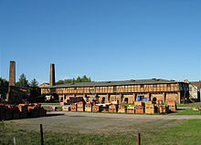
The first brick factory on Neuenhagener Insel is said to have existed as early as the time of the Wars of Liberation (1812–1815). Rich deposits of band silt were discovered in the second half of the 19th century. Brick production came about by chance for private use and then expanded more and more. In 1881 the first ring furnace worked on the island. The largest brickworks entrepreneur, Dornbusch from Bralitz, was gradually able to buy up several small brickworks. At the height of brick production there were 10 brick factories on the island. As with most of the Brandenburg brickworks, industry began to decline shortly before the outbreak of the First World War . Only the former Hietzig steam brickworks in Altglietzen has survived to this day.
Some earlier clay pits exist as evidence of the raw material extraction at that time , such as a larger pit with steep slopes near the highest elevation, the granite mountain, which is popularly called "devil's eye".
At the beginning of the 1950s, large areas of sand and gravel were extracted in the northern area around the Oderberg - Neuenhagen road . Numerous gravel pits were built between Bralitz and Neuenhagen and north of the Oder in Hohensaaten. Many people from the island villages found work and bread here. After the Neuenhagen gravel deposit was largely dismantled, new pits were built in the early 1970s directly in the village of Bralitz. In 1993 the production in Bralitz was stopped. Residual lakes have been partially renatured , and pine trees have been laid on some areas.
Agriculture
Agriculture was a more stable economic pillar . Beet cultivation was of particular importance . In 1948, a machine rental station (MAS) was founded in Neuenhagen to support small agricultural businesses , which was converted into a machine-tractor station in 1950 , a repair technical station (RTS) in 1960 and finally in 1964 the district operation for agricultural technology ( KfL) merged. In 1955 an agricultural production cooperative (LPG) was founded in Neuenhagen , which merged with von Bralitz in 1960. After the accession of the GDR , the KfL was dissolved. Today there is an industrial park on the site .
traffic
The original meaning of the Neuenhagener Oderinsel lay in the relatively simple river crossing from Oderberg in order to reach the newly acquired Neumärk area. On the lower Oder there are only very few places where two flood-proof banks come close to one another within less than 2 km. The street Oderberg- (Alt-) Glietzen- Zehden should have been of national importance even before 1200.
The first bridge over the Oder was built with the completion of the canal in Hohenwutzen. But these and most of the subsequent buildings were repeatedly destroyed by ice and floods . Until the construction of the Saldern Bridge (1903, destroyed 1945), the river was mostly crossed by ferry. The bridge, still in use today, was built between 1954 and 1958.
The Neuenhagener Insel was connected to the railway network by the Angermünde – Bad Freienwalde railway . The line was closed in 1997 and dismantled in 2009. The station Oderberg-Bralitz is in private ownership .
Another railway line crossed the southern part of the island , the Freienwalde – Zehden small railway . After the destruction of the railway bridge over the Oder in 1945, the railway ran to the Hohenwutzen terminus until 1966 , at last only for freight traffic .
Places and sights

Since the territorial reform of 2003, all villages on the Neuenhagener Oder Islands - with the exception of the part of the city of Oderberg south of the Old Oder - have belonged to the city of Bad Freienwalde (Oder) as districts :
Altglietzen: Last brick factory in operation on the island.
Bralitz: Since the closure of the railway and the cessation of gravel mining, Bralitz has been on the “shadowy side” of the island, so to speak. It is a quiet place to live between the forest and Niederoderbruch and is largely spared from through traffic .
Hohenwutzen: The road bridge over the Oder was only opened to public border traffic in 1993. Today there is a lot of traffic in Hohenwutzen, because residents from the Berlin area in particular use the border crossing to shop at the markets in Osinów Dolny (formerly Niederwutzen).
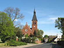
Neuenhagen: Center of the Neuenhagen island. Location of the school, kindergarten, castle (mansion) and a church built in the neo-Romanesque style.
Neutornow : In the years 1755–1760, the district of Neutornow was created , characterized by the chimney of the pumping station, which was commissioned in 1895, which can be seen from afar. In the cemetery next to the church is the grave of Louis Henry Fontane , the father of Theodor Fontane. Above Neutornow, on the so-called Holländer, there was a prehistoric burial ground, of which the Bronze Age finds can be seen in the Oderland Museum in Freienwalde.
Schiffmühle: At the exit of Schiffmühle is the renovated home of Louis Henry Fontane , who spent the last years of his life here. Today it is a museum.
Nature and conservation

The steep slopes of Neuenhagener Insel, inclined to the south, are rarely used because of their barreness and are the location of warm, dry grass vegetation .
The Neuenhagen clay pits are protected as a nature reserve and the Gabower slope edge is registered as an FFH area. A large part of the area also belongs to the “Schorfheide Chorin” bird sanctuary and the biosphere reserve of the same name . Valuable habitats, especially as breeding grounds for the hoopoe , form the transitions from the wetlands of the Oder floodplain to the valley sand terraces and dry slopes of the Oder island. In total, around three quarters of the Neuenhagener Oderinsel are registered as a Special Protection Area (SPA) .
See also
Web links
- Landscape profile 80300 Neuenhagener Oderinsel. Federal Agency for Nature Conservation
- Land use plan 2014–2025, part 2: Neuenhagen Island (PDF). City of Bad Freienwalde
- 3D visualization of the Neuenhagener Insel, in: Die Erde . Vol. 143, 2012
- History. Association of Schloss-Neuenhagen-Insel
- Eike Gringmuth-Dallmer: People and the environment in the Oder region. Volkswagen Foundation project , 1999
Individual evidence
- ↑ The Witte knights may have a tribal relationship with the Lauenburg noble family Wackerbarth .
- ↑ a b Neuenhagen ( Memento from February 14, 2008 in the Internet Archive ) on the website of the Society for the Development and Promotion of the Märkische Eiszeitstraße eV (vlg. Märkische Eiszeitstraße )
- ↑ Schiffmühle ( Memento from February 14, 2008 in the Internet Archive ) on the website of the Society for the Development and Promotion of the Märkische Eiszeitstraße eV
- ↑ Inselwanderung Insel Neuenhagen at AllTrails, November 4, 2012.


