Moryń
| Moryń | ||
|---|---|---|

|
|
|
| Basic data | ||
| State : | Poland | |
| Voivodeship : | West Pomerania | |
| Powiat : | Gryfino | |
| Area : | 6.00 km² | |
| Geographic location : | 52 ° 51 ' N , 14 ° 24' E | |
| Residents : | 1630 (June 30, 2019) |
|
| Postal code : | 74-503 | |
| Telephone code : | (+48) 91 | |
| License plate : | ZGR | |
| Economy and Transport | ||
| Street : | Ext. 125 Bielinek ↔ Wierzchlas | |
| Next international airport : | Szczecin-Goleniów | |
| Gmina | ||
| Gminatype: | Urban and rural municipality | |
| Gmina structure: | 18 villages | |
| 9 school offices | ||
| Surface: | 125.00 km² | |
| Residents: | 4295 (Jun. 30, 2019) |
|
| Population density : | 34 inhabitants / km² | |
| Community number ( GUS ): | 3206063 | |
| Administration (as of 2013) | ||
| Mayor : | Jan Maranda | |
| Address: | Pl. Wolności 1 74-503 Moryń |
|
| Website : | www.moryn.pl | |
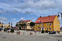
Moryń ( German Mohrin , formerly Morin ) is a city in the Polish West Pomeranian Voivodeship in the Powiat Gryfiński ( Greifenhagener Kreis ). It is also the seat of an urban and rural municipality .
Geographical location
The city is located in the Neumark , about 40 kilometers east of Eberswalde on the Jezioro Morzycko (Mohriner See) and the Słubia (Schlibbe) , a tributary of the Oder . The 3.62 km² large Mohriner See is one of the deepest lakes in the Pomeranian Lake District with a water depth of 58.5 m .
history
On the western shore of the Mohriner See there was once an early castle complex on a peninsula, where Margrave Otto V had the Stolzenburg built around 1365 . The existence of this second castle was short-lived, as early as 1399 it was deserted again.
The time of origin of the city south of the peninsula is unknown. The knight Otto von Barmenstede, who handed over patronage over the church in 1265, is regarded as the founder. Mohrin has been named as a city since 1306. It had the rights of an immediate city , such as the right to mint coins and its own jurisdiction. Mohrin was surrounded by a city wall with 28 soft houses and had three gates.
Between 1402 and 1454 it was owned by the Teutonic Order . Devastated several times by city fires and destroyed by the Hussites in 1433 , Mohrin hardly developed because of its location away from all trade routes. In the course of the 15th century it lost many rights and became a noble media city , the inhabitants of which were predominantly arable citizens . The craft consisted of shoemakers and linen weavers. In 1783 the last great city fire raged.
In the 20th century tourism gained economic importance in Mohrin.
Mohrin belonged to the district of Königsberg Nm until 1945 . in the administrative district of Frankfurt in the province of Brandenburg .
At the end of the Second World War , the majority of the residents fled from the approaching front in 1945 . After the war ended, the city was placed under Polish administration. At that time, only a hundred people lived in the city, sixty of them Germans. The immigration of Polish migrants began, some of whom came from areas east of the Curzon Line conquered by Poland after the First World War . After the war, the Polish administrative authorities refused to allow Mohrin's war refugees to return to their homes in the city . The Germans who remained in the city were expelled in the period that followed .
The city with the Mohriner See is frequented by water sports enthusiasts and holidaymakers.
Demographics
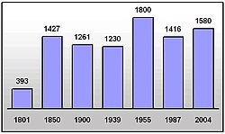
| year | population | Remarks |
|---|---|---|
| 1750 | 637 | |
| 1801 | 939 | including a ten-member protective Jewish family (216 active military personnel) |
| 1840 | 1,206 | |
| 1850 | 1,427 | including two Catholics and 64 Jews |
| 1858 | 1,524 | including a Catholic and 52 Jews |
| 1867 | 1577 | on December 3rd |
| 1871 | 1559 | on December 1, including 1499 Protestants, five Catholics, six other Christians, 49 Jews |
| 1905 | 1198 | mostly evangelicals |
| 1933 | 1,285 | |
| 1939 | 1,230 |
traffic
rail
Between 1892 and 1991 the city was connected via the Butterfelde-Mohrin station (pl. Przyjezierze-Moryń) to the Wriezen – Jädickendorf railway line with direct connections to Berlin and Königsberg in Neumark . After 1945 the rail line over the Oder Bridge was interrupted, so that until 1991 there was still a shuttle service between Siekierki (formerly Gäckerick-Alt-Rüdnitz) and Godków (formerly Jädickendorf).
Town twinning
- Bronson (United States)
- Joachimsthal (Germany, Brandenburg)
- Schwedt / Oder (Germany, Brandenburg)
Attractions
The Romanesque town church is a three-aisled field stone building with a free-standing tower from the 13th century. The oak of an old wooden window frame in the east gable was felled "around / after 1260". In it is an altar made of granite, which is sometimes considered older than the church, but this is scientifically controversial. The church is considered a valuable cultural monument in West Pomerania.
In front of the facade of the nursing home, at that time an educational institution for children, there is a monument by the sculptor Heinrich Wefing, dedicated to the founder Christian Friedrich Koch . The monument is one of the rare surviving works of this type in the West Pomeranian Voivodeship.
The city wall has been preserved, but without the soft houses and gates. The last of the three former gates, the pointed arch of the sea gate, was lost during or after the Second World War.
Due to the poor development of the city, the medieval city plan was well preserved.
local community
The area of the urban and rural municipality has an area of 125 km², on which about 4,400 inhabitants live. It comprises the nine school departments Bielin ( Bellin ), Dolsko ( Dölzig ), Gądno ( Guhden ), Klępicz ( Klemzow ), Mirowo ( Woltersdorf ), Nowe Objezierze ( Groß Wubiser ), Przyjezierze ( Butterfelde ), Stare Objezierze ( Klein Wubiser ) and Witnicaierze ( Vietnitz ).
Personalities
- Christian Friedrich Koch (1798–1872), German lawyer
- Bernhard Lau (1875–1926), airship pilot
- Walter Kühle (1888–1972), German politician (NSDAP)
- Ernst Braun (1893–1963), neurologist, psychiatrist and university professor
- Paul Quincy (1944–2013), German author and translator
literature
- Friedrich Wilhelm August Bratring : Statistical-topographical description of the entire Mark Brandenburg . Volume 3, Berlin 1809, pp. 106-108 .
- Heinrich Berghaus : Land book of the Mark Brandenburg and the Margraviate Nieder-Lausitz in the middle of the 19th century . Volume 3, 1st edition, Brandenburg 1856, pp. 399–401.
- W. Riehl and J. Scheu (eds.): Berlin and the Mark Brandenburg with the Margraviate Nieder-Lausitz in their history and in their present existence . Berlin 1861, pp. 411-412.
Web links
- City website (Polish)
Individual evidence
- ↑ a b population. Size and Structure by Territorial Division. As of June 30, 2019. Główny Urząd Statystyczny (GUS) (PDF files; 0.99 MiB), accessed December 24, 2019 .
- ↑ a b c W. Riehl and J. Scheu (eds.): Berlin and the Mark Brandenburg with the Margraviate Nieder-Lausitz in their history and in their current existence . Berlin 1861, pp. 411-412.
- ^ Friedrich Wilhelm August Bratring : Description of the entire Mark Brandenburg . Volume 3: Die Neumark Brandenburg , Berlin 1809, p. 107 ( online ).
- ^ Heinrich Berghaus : Land book of the Mark Brandenburg and the Margraviate Nieder-Lausitz in the middle of the 19th century . Volume 3, 1st edition, Brandenburg 1856, pp. 399–401.
- ↑ a b Royal Statistical Bureau: The communities and manor districts of the Prussian state and their population . Part II: Province of Brandenburg , Berlin 1873, pp. 118–119, No. 5 ( online ).
- ^ Meyer's Large Conversational Lexicon . 6th edition, Volume 14, Leipzig / Vienna 1908, p. 24 ( online ).
- ^ A b Michael Rademacher: German administrative history from the unification of the empire in 1871 to the reunification in 1990. koenigsberg_n.html # ew39kbnm9mohrin. (Online material for the dissertation, Osnabrück 2006).
- ↑ http://www.moryn.pl/
- ↑ Friske, Matthias, Heussner, Karl-Uwe & Walther, Eckhart (2013): New Findings on the Churches of Mohrin (Moryn) and Dölzig (Dolsko) in Neumark , in: Yearbook for the History of Central and Eastern Germany , 59, Pp. 3-22. ISSN 0075-2614


