Yells

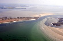
The Gellen or the Gellen peninsula is a headland (a so-called sand hook ) at the southernmost end of the island of Hiddensee . The southern part is under nature protection as an important bird sanctuary and is assigned to protection zone I of the Vorpommersche Boddenlandschaft National Park , so it is not accessible to the public.
It consists of post-glacial ( Holocene ) sand deposits and grows a few meters further south every year. By dredging the fairway between the island of Bock and the Gellen, the coastal compensation is prevented, as occurs naturally in the southeastern Baltic Sea area with its numerous spits .
topography
The Gellen is a maximum of 500 meters wide and approx. 5 km long and only a few meters high. The sequence of the individual beach ridges can be clearly seen in maps and aerial photographs . Topographically, it can be divided into two areas:
- Altgellen ( Neuendorf to Klimphores Bay)
- Neugellen (Klimphores Bay to the southern tip), origin from approx. 12th century. The southern part of the Neugellens is blocked.
While the Neugellen grows towards the south, sand is removed from the Altgellen. To the south of the Gellens there is an extensive windwatt (the Vierendehlgrund ), which occasionally dries up. The growth of the Gellens has slowed down considerably since around 1990 and will come to a standstill in the next few decades, as it will then come into contact with the fairway to the southwest.
Place names on the Gellen are from north to south:
- Bank projections: Langer Barg, Klimphoreshaken / Klemmhuernhaken, Langen Hasenwerderscher Ort, Kl. Ugel, Gr. Ugel
- Bays and Riegen : Schwarzer Peter, Klemmhuern / Klimphoresbucht, Karkensee, Priestersee
On the west coast of Neugellens there is a cliff up to four meters high, which, unlike the thorn bush, does not come from ice age deposits, but from dune formation. A coastal protection forest made of wind-resistant pines has been planted on the Altgellen , further south there are also some individual birches and other trees. However, most of it is covered with dune grasses, grasslands and heather.
Coastal defense
In 1864, as a result of a storm flood south of Neuendorf , on the so-called Black Peter, there was a breakthrough 8 meters deep. Despite intensive protection efforts, this could not be closed in the first decades, it even widened to 250 meters. Only after the construction of the Steindamm did the Gellen belong again to Hiddensee.
Today there is a risk of a breakthrough at the level of Klimphores Bay. There the land is only 250 m wide. Groynes (partly also stone groynes), sand flushing, artificial dunes and plantations of beach grass and pines counteract the erosion process on the Altgellen.
Buildings
At the beginning of the 14th century, the Gellenkirche, a small beacon (called Luchte) and the first port on the island of Hiddensee were built here. The name Karkensee (Kirchensee) for a bay at the barrier at Südgellen still indicates this.
A lighthouse, the Gellen lighthouse, which marks the northern entrance to the so-called Gellenstrom , is still on the peninsula.
literature
- Günter Möbus: How Hiddensee became an island. Helms Verlag, Schwerin 2001, ISBN 3-93118587-7
Web links
Coordinates: 54 ° 29 ′ 6 ″ N , 13 ° 4 ′ 7 ″ E

