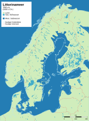
Littorina transgression
The Littorina transgression is a regional transgression event in north-central and northern Europe that is associated with the post- glacial glacioeustatic rise in sea level and, among other things. a. initiated the formation of the Baltic Sea in its current form. Salt water penetrated from the Atlantic and the North Sea via the Kattegat and the Danish Belte and Sunde into the Baltic Sea basin, which is filled with fresh water (meltwater). The transgression is named after the "common periwinkle" ( Littorina littorea ), which indicates brackish water and whose fossil shells suddenly appear in old deposits of the Baltic Sea basin.
The exact time at which the transgression began is unclear, as is the question of whether it was a single event or a series of transgression events. The first signs of brackish conditions in the south-western Baltic Sea ( Blekinge , Bornholm Basin) can be found in sediments from around 8030 BC. BC (8900 uncalibrated 14 C -years BP * ). Various reconstructions of the development of the sea level in the southwestern Baltic Sea show a rapid rise between about 6900 and 4900 BC. BC (8000 to 6000 uncalibrated 14 C years BP * ) with rates of water level rise of 2.5 cm / a between 6820 and 6150 BC BC (7900 to 7300 uncalibrated 14 C years BP * ). The Littorina Transgression led to dramatic changes in the ecosystems and along the coastlines, especially in this region. The transgression ended around 4550 BC. BC (5700 uncalibrated 14 C years BP * ). After this date there were no more significant changes in the water level in the Baltic Sea.
The question of which of the three straits between the North Sea and the Baltic Sea ( Great Belt , Little Belt , Öresund ) was the first gateway for the salt water is also debatable . This is of great importance for the history of settlements on the southern Baltic Sea. Depending on whether the flooding occurred through the Belte or the Øresund, the settlements near the shore southwest or northeast of the Darßer Schwelle ** would have been affected first. Radiocarbon dating of the identified transgression horizon in the Mecklenburg Basin and in the Arkona Basin indicate that the sea invasion first took place via the Belte, as these sediments in the Mecklenburg Basin were found to be around 500 14 C years older. This is also in line with the significantly lower minimum depth of the Øresund (8 m, Drogden threshold) compared to the Belten and Darßer threshold (≥ 20 m). This is contradicted by the old age of marine-influenced deposits in Blekinge and the Bornholm Basin. Apparently, the sea penetrated into some areas of the southern Baltic Sea via the Öresund before the Mecklenburg and Arkona basins were flooded. The current low depth of the Drogden Sill could be explained by an excessive uplift of the Øresund region, which could be related to tectonic movements on the Teisseyre – Tornquist Line .
The inland sea created in the course of the Littorina Transgression is called the Littorina Sea in paleogeographical terms . It can be seen as the first stage of today's Baltic Sea. Data, which were obtained using different methods, indicate that the salinity of the Littorina Sea was higher everywhere than in the corresponding marine areas of the present-day Baltic Sea, but nowhere were fully marine conditions (i.e. ≈ 35 ‰) achieved. The Littorina Sea phase lasted until around the turn of the ages (approx. 2000 uncalibrated 14 C-years BP * ) and was replaced by the Lymnaea Sea phase, which is characterized by increasing sweetening of the water body.
Remarks
- * as stated in Rößler (2006), converted into years before BC using CalPal
- ** Today a submarine threshold that extends between the Darß and the Danish island of Falster and separates the Mecklenburg Basin with the southern Belt Sea (including Mecklenburg Bay ) southwest of the threshold from the Arkona Basin with the Arkona Sea northeast of the threshold
literature
- Doreen Rößler: Reconstruction of the Littorina Transgression in the Western Baltic Sea. Marine science reports, No. 67. Institute for Baltic Sea Research, Warnemünde 2006 ( PDF 8.6 MB).
Individual evidence
- ↑ cf. Sinking Coasts: Geosphere, Climate and Anthroposphere of the Holocene Southern Baltic Sea (SINCOS-II). Center for Baltic and Scandinavian Archeology.
- ↑ see table 2.2. in Per Westman, Stefan Wastegård, Kristian Schoning: Salinity change in the Baltic Sea during the last 8,500 years: evidence, causes and models. Technical Report TR-99-38, Svensk Kärnbränslehantering AB, Stockholm 1999 ( ResearchGate )
- ^ Paul R. Pinet: Invitation to Oceanography. 5th edition. Jones and Bartlett Publishers, 2009, ISBN 978-0-7637-5993-3 , p. 145
- ↑ Bernhard Weninger, Olaf Jöris: A 14 C age calibration curve for the last 60 ka: the Greenland-Hulu U / Th timescale and its impact on understanding the Middle to Upper Paleolithic transition in Western Eurasia. Journal of Human Evolution. Vol. 55, 2008, pp. 772-781, doi: 10.1016 / j.jhevol.2008.08.017 (alternative full text access : ResearchGate ).

