
Little Belt
| Little Belt | ||
|---|---|---|
 |
||
| Connects waters | Kattegat | |
| with water | Baltic Sea | |
| Separates land mass | Jutland | |
| of land mass | Funen | |
| Data | ||
| Geographical location | 55 ° 8 ' N , 9 ° 49' E | |
|
||
| length | 70 km | |
| Smallest width | 600 m | |
| Greatest depth | 90 m | |
| Coastal towns | Fredericia , Middelfart , Assens | |
| bridges | Lillebæltsbro , Ny Lillebæltsbro | |
 |
||

The Little Belt ( Danish Lillebælt ) is the strait between the Jutland peninsula (Jylland) and the island of Fyn (Fyn) in Denmark . It is the most westerly natural connection between the Kattegat in the north and the Baltic Sea . In the north, the Little Belt borders the Samsø Bælt on a line between Juelsminde and Æbelø and begins with the funnel (Danish. Tragten ) at Fredericia . This is followed by the approximately ten kilometers long, M-shaped, winding narrow part with a width of less than two kilometers. In the further course it narrows to about 600 meters and then becomes about three kilometers wide. It is traditionally also called Middelfart Sund or Snævringen .
At Middelfart there are two bridges in operation over the Little Belt, the old Lillebæltsbro (railway / road bridge) from 1935 and Ny Lillebæltsbro (motorway bridge) which opened in 1970. Due to the winding course of the water, these two bridges are almost at right angles to each other. To the west of the old bridge, two 380 kV three-phase overhead lines cross the Little Belt. West (baltic Windwärts) which branches off a Koldingfjord called Fjord from.
At Sønder Stenderup , the narrow part of the belt is followed by the 70 km long and ten to 20 km wide part of the belt. Its southern part near the island of Alsen ( Danish (Als) ) is also called Alsenbelt in German . The south-east facing southern exit of the Little Belt opens up to the so-called Danish South Sea with many small islands south of Funen.
According to the definition of the International Hydrographic Organization , the Little Belt ends in the south on a line from Falshöft (according to the given coordinates more precisely from the northeasternmost point of the Geltinger peninsula ) to Vejsnæs Nakke , the southernmost point of Ærø .
About nine percent of the water exchange between the Kattegat as a bay of the North Sea and the inland Baltic Sea flows through the Little Belt. There is an inflow of salt and oxygen-rich Kattegat water in the depths and an outflow of low-salt water from the Baltic Sea in the upper layers.
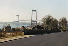
Ny Lillebæltsbro , motorway bridge over the Little Belt

Lillebæltsbroen , railway and road bridge over the Little Belt


Trivia
In Germany, the Belt is known from the first verse of the German song by Hoffmann von Fallersleben : "[...] from the Maas to the Memel / from the Etsch to the Belt [...]" . The Belt represents a possible northern border of the unified Germany desired by the German national movement in the 19th century.

See also
Web links
- Area information for sailors: The Little Belt on esys.org
- Fishing in the Little Belt on meeresangeln-in-daenemark.de
Individual evidence
- ^ Horst Meesenburg, Ole Ventegodt: Lillebælt. In: The Danske store. Gyldendal. accessed on April 2, 2020.
- ↑ International Hydrographic Organization : Limits of Oceans and Seas (PDF) Special Publication № 23, 3rd Edition 1953, p. 4, accessed on April 6, 2020.