Blekinge
| Blekinge | |
|---|---|

|

|
| Basic data | |
| Part of the country (landsdel) : | Götaland |
| Province (län) : | Blekinge län |
| Surface: | 3,055 km² |
| Residents: | 152,315 (Dec 31, 2012) |
| Population density: | 50 inhabitants per km² |
| Highest elevation: | Rävabacken 189 m ö.h. |
| Largest lake: | Halen |
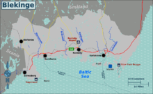
Blekinge is a historical province ( Swedish landskap ) in southern Sweden .
In today's administrative structure of Sweden this corresponds to the province of Blekinge län . The largest city and capital of the province on Hanöbucht is Karlskrona . Other important cities are Karlshamn , Ronneby , Sölvesborg and Olofström . There is a military and civil airport in Kallinge near Ronneby.
On March 12, 2018 it was announced that Princess Adrienne of Sweden , the second daughter of Princess Madeleine , will from now on bear the title of Duchess of Blekinge. Blekinge has never been a duchy before.
geography
In the north, on the border with Småland , the country rises 130 to 180 meters above sea level. From this area the terrain slowly descends to the south and east towards the Baltic Sea . In the northern area the subsoil is poor in nutrients with rocky hills and swamps, where mainly conifers grow. In the central area with its many lakes and even more in the coastal zone, there are nutrient-rich soils with deciduous trees, of which the beech is particularly common. Blekinge's waters flow mainly southwards. The southern coast has a wide archipelago ( Blekinge archipelago ) and is characterized by numerous bays.
history
Blekinge belonged to Denmark until 1658 and for a long time was the site of various battles between the Danish and Swedish empires. Many cities and villages were looted or pillaged. With the Peace of Roskilde Blekinge went to Sweden together with Schonen and Halland .
Blekinge experienced its greatest heyday with the time of the Swedish great power. In 1680 the naval port of Karlskrona was built , and ten years later it was Sweden's third largest city. The sheltered location in the Blekinge archipelago , where few defenses were sufficient to protect the site, and the presence of many oaks inland contributed to the choice of location for the naval port. Karlshamn was also created at the same time; but existing places like Ronneby and Sölvesborg were inhibited in their development. Karlshamn and Karlskrona took the place of the nearby medieval trading centers Lyckå and Elleholm . In the 18th century, a quarter of Blekinge's population lived in cities, which was unusually high at the time. After that, the province developed more slowly than the rest of Sweden, and agriculture such as fruit growing dominated the economy again.
Landscape symbols
- Flower: Small-flowered Mullein ( Latin Verbascum thapsus )
- Animal: stag beetle ( Lucanus cervus )
- Bird: Nuthatch ( Sitta europaea )
- Fish: Cod ( Gadus morhua )
- Mushroom: giant porling
- Stein: Blekinger coastal gneiss
literature
- Blekinge . In: Bernhard Meijer (Ed.): Nordisk familjebok konversationslexikon och realencyklopedi . 2nd Edition. tape 3 : Bergsvalan – Branstad . Nordisk familjeboks förlag, Stockholm 1905, Sp. 672 (Swedish, runeberg.org ).
Web links
- Official website (various languages)
Individual evidence
- ↑ Folkmängd i landskapen ( Memento from September 24, 2015 in the Internet Archive )

