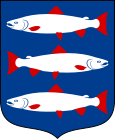
Ångermanland
| Ångermanland | |
|---|---|

|

|
| Basic data | |
| Part of the country (landsdel) : | Norrland |
| Province (län) : | Västernorrlands län , Jämtlands län , Västerbottens län |
| Surface: | 20,716 km² |
| Residents: | 133,535 (December 31, 2008) |
| Population density: | 7 inhabitants per km² |
| Highest elevation: | Tåsjöberget 635 m ö.h. |
| Largest lake: | Tåsjön |
Ångermanland is a landscape in the Swedish region of Norrland . It includes parts of the administrative districts Västernorrlands län , Jämtlands län and Västerbottens län , it borders in the south on the historical province Medelpad , in the west on Jämtland , in the north on Lapland , in the northeast on Västerbotten and in the east on the Baltic Sea and the Gulf of Bothnia . The name of the landscape comes from the old Swedish Angermannaland , where anger stands for bay or fjord . On June 17, 2015 it was announced that Prince Nicolas of Sweden , the son of Princess Madeleine , will from now on bear the title of Duke of Ångermanland. Ångermanland has never been a duchy before.
geography
The Baltic Sea coast is strongly structured here with deep bays where natural harbors are located. There are numerous small islands ( skerries ) off the coast . The ridges are heavily ramified and there are many elongated lakes in the valleys, of which Tåsjön , around 40 kilometers long and only three kilometers wide, is the longest lake that lies entirely in Ångermanland. The highest point in the landscape (Bunkfjället) is relatively low at 750 meters.
The high coast on the Gulf of Bothnia is a UNESCO World Heritage Site . Investigations into the Scandinavian land uplift are being carried out on this stretch of coast . The land here rises by around 1 cm per year.
In the vicinity of watercourses, especially on both sides of the Ångermanälven , there are nutrient-rich soils that are used for agriculture. On the remaining areas there is forest, which is often interspersed with swampy areas.
various
The dialects in Ångermanland form a fairly uniform dialect group that is strongly demarcated to the south. To the northwest, the Ångermanland extends far into the area of Lapland .
The well-known Surstromming comes from Ångermanland, more precisely from the island of Ulvön .
Several burial mounds from the younger Iron Age have been found in an elongated area that stretches from the Baltic coast about 100 kilometers inland . There is also a large collection of stone carvings at Näsåker in Sollefteå municipality .
Landscape symbols
- Flower: Pansy ( lat. Viola tricolor )
- Animal: Beaver ( Castor fiber )
- Bird: Gray Woodpecker ( Picus canus )
- Fish: whitefish ( Coregonus )
Web links
- Official website (English, German, Swedish)
swell
- ↑ Folkmängd i landskapen ( Memento from August 17, 2013 in the Internet Archive )
Coordinates: 63 ° 9 '14.4 " N , 17 ° 14' 16.8" E