
Satakunta
| coat of arms | map |
|---|---|

|
  |
| Basic data | |
| Country: | Finland |
| Municipalities: | 18th |
| Administrative headquarters: | Pori |
| Surface: | 8,411.87 km² of which land: 7,957.11 km² |
| Residents: | 222,629 May 31, 2016 |
| Population density: | 26.5 inhabitants per km² |
| ISO 3166 : | FI-17 |
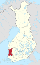
Satakunta [ ˈsɑtɑˌkuntɑ ] ( Swedish Satakunda ) is one of the 19 landscapes in Finland . It is located in the west of the country in the province of Western Finland . Satakunta borders in the north on Ostrobothnia and South Ostrobothnia , in the east on Pirkanmaa , in the south on Kanta-Häme and Varsinais-Suomi and in the west on the Baltic Sea . The administrative seat and largest city is Pori . The population of Satakunta is almost exclusively Finnish-speaking. Only 0.2% of the population speak Swedish as their mother tongue.
The current landscape was formed in 1997 in the course of the Finnish territorial reform from the northern part of the Turku-Pori province . The naming was based on the historical landscape of Satakunta, which existed until 1634 as the administrative province of the Swedish Empire. The western part of Pirkanmaa also belonged to the historical landscape.
coat of arms
Description: In the shield divided by blue and gold, a gold-crowned, red-armored, red-tongued and red-eyed black bear with a gold-hilted silver sword is accompanied in both paws by two silver seven-pointed stars . A golden crown rests on the shield .
- see also the coat of arms of the Finnish region of Satakunta
Communities
There are 17 parishes in Satakunta, seven of which are cities (in bold). The population as of December 31, 2018 is given in brackets.
|
Web links
- Statistics on Finland (PDF)
Individual evidence
- ↑ Tilastokeskus.fi - Finnish Statistics Office (Finnish)
- ↑ Statistical Office Finland: Table 11ra - Key figures on population by region, 1990-2018
Åland | Malice | Karelia | Lapland (Finland) | Ostrobothnia | Satakunta | Savo | Uusimaa | Varsinais-Suomi