Kokemäki
| coat of arms | map |
|---|---|

|

|
| Basic data | |
| State : |
|
| Landscape : | Satakunta |
| Administrative community : | Pori |
| Geographical location | 61 ° 15 ′ N , 22 ° 21 ′ E |
| Surface: | 531.34 km² |
| of which land area: | 481.26 km² |
| of which inland waterways: | 50.08 km² |
| Residents : | 7,226 (Dec. 31, 2018) |
| Population density : | 15 inhabitants / km² |
| Municipality number : | 271 |
| Language (s) : | Finnish |
| Website : | www.kokemaki.fi |
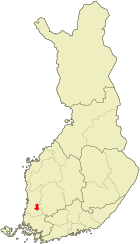
Kokemäki [ ˈkokeˌmæki ] (Swedish Kumo ) is a town with 7226 inhabitants (as of December 31, 2018) in southwestern Finland . It is located around 40 km east of Pori in the Satakunta landscape .
It lies on both sides of the river Kokemäenjoki , to which it gave its name, and has a rural character. Traditionally, agriculture and fishing in the river are important, today so is the metalworking industry. The city administration is the largest employer with around 320 employees.
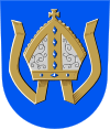
The Kokemäki settlement has existed since the Middle Ages; According to tradition, the Finnish national saint Heinrich von Uppsala spent the last night of his life in the preaching house of St. Heinrich in 1156 before he was slain by the farmer Lalli in neighboring Köyliö . The bishop's miter now adorns the city's coat of arms.
In Kirchdorf Kokemäki there are two churches, one for a 1786 built stone church, on the other hand, the present parish church, a wooden cross Church, 1886 built according to plans by CJ of Heideken. Only the sacristy , built in stone in the middle of the 16th century, remains of the village's medieval wooden church .
Districts
Aakula, Askola, Haavasoja, Haistila, Hampula, Harola, Hassala, Herttola, Hintikkala, Huivoo, Hyrkölä, Järilä, Kaarenoja, Kakkulainen, Kankaantausta, Kareksela, Kaukaritsa, Kaurula, Kauvatsa, Korkeaoja, Ketemolaiett, Ketemolae , Koskenkylä, Krannila, Krootila, Kuittilo, Kukola, Kuoppala, Kuurola, Kyttälä, Köömilä, Laikko, Lempainen, Mattila, Meinikkala, Paistila, Pappila, Peipohja, Pelhola, Penttilä, Pirkkinäinen (Birknäsala, Pumpala, Pukkkinvaala, Pumpala, Pukkvaala) Pälpälä, Riste, Ronkka, Rudanko, Ruikkala, Ryytsälä, Sonnila, Säpilä, Talonen, Teikari, Tulkkila, Tuomaala, Vallila, Viikari, Villiö, Vitikkala, Vuolle (Vuoltee), Ylistaro, Äimälä, Öykkäri.
Personalities
- Kullervo Manner (1880–1939), politician and communist leader
- Eemil Nestor Setälä (1864–1935), politician
Web links
Individual evidence
- ↑ Maanmittauslaitos (Finnish land surveying office): Suomen pinta-alat kunnittain January 1, 2010 . (PDF; 199 kB)
- ↑ Statistical Office Finland: Table 11ra - Key figures on population by region, 1990-2018