Pomarkku
| coat of arms | map |
|---|---|

|

|
| Basic data | |
| State : |
|
| Landscape : | Satakunta |
| Administrative community : | Pori |
| Geographical location | 61 ° 42 ′ N , 22 ° 0 ′ E |
| Surface: | 332.07 km² |
| of which land area: | 301.12 km² |
| of which inland waterways: | 30.95 km² |
| Residents : | 2,146 (Dec. 31, 2018) |
| Population density : | 7.1 inhabitants / km² |
| Municipality number : | 608 |
| Language (s) : | Finnish |
| Website : | www.pomarkku.fi |
Pomarkku ( Swedish : Påmark ) is a municipality with 2146 inhabitants (as of December 31, 2018) in western Finland . It is located around 25 kilometers northeast of the port city of Pori in the Satakunta landscape . Only Finnish is spoken in Pomarkku .
local community
The municipality was established in 1868 and includes beside the Kirchdorf Pomarkku the places Harhala, Honkakoski, Kiilholma, Kivijärvi, Laitila, Längelmäki, Tuunajärvi and Uusikylä.
coat of arms
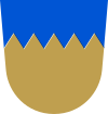
Description of the coat of arms : "In gold a blue shield head , into which five golden tips rise".
Attractions
The church village of Pomarkku has a well-preserved historical center with numerous picturesque wooden houses from the 19th century. The place has two churches, in addition to the granite church built in 1921, the old wooden church built in 1802 , the interior of which is decorated with numerous wall paintings.
In addition to the municipal administration, the main employers include the shoe industry, as well as some companies in the wood and metal processing industry.
Web links
Individual evidence
- ↑ Maanmittauslaitos (Finnish land surveying office): Suomen pinta-alat kunnittain January 1, 2010 (PDF; 199 kB)
- ↑ Statistical Office Finland: Table 11ra - Key figures on population by region, 1990-2018