Jämijärvi
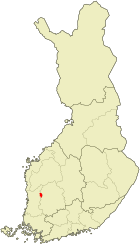
| coat of arms | map |
|---|---|

|

|
| Basic data | |
| State : |
|
| Landscape : | Satakunta |
| Administrative community : | North Satakunta |
| Geographical location | 61 ° 49 ′ N , 22 ° 42 ′ E |
| Surface: | 224.35 km² |
| of which land area: | 214.36 km² |
| of which inland waterways: | 9.99 km² |
| Residents : | 1,809 (Dec. 31, 2018) |
| Population density : | 8.4 inhabitants / km² |
| Municipality number : | 181 |
| Language (s) : | Finnish |
| Website : | www.jamijarvi.fi |
Jämijärvi [ ˈjæmiˌjærʋi ] is a municipality with 1809 inhabitants (as of December 31, 2018) in western Finland . It is located around 60 km northeast of the port city of Pori in the Satakunta landscape .
The municipality was established in 1865 and includes beside the Kirchdorf Jämijärvi places Kauppila Kontti, Palokoski, Peijari, Pitkäniemi, Ruupanperä, Suurimaa, Sydänmaa, Tykköö and VIHU.
Jämijärvi is the highest municipality in western Finland. The level of the eponymous lake Jämijärvi in the center of the municipality is 100.6 m above sea level, the highest point is Soininharju at 185.4 meters. The post-glacial landscape is characterized by terminal moraines and osers ; in the south the community has a share in the Hämeenkangas ridge. Around two thirds of the municipality is forested.
Jämijärvi Airfield is a center of gliding in Finland.
The central school Jämijärvi (Jämijärven keskuskoulu) maintains a partnership with the integrated comprehensive school Kastellaun / Hunsrück .
Sons and daughters of the church
- Kirsi Välimaa (* 1978), cross-country skier
Web links
Individual evidence
- ↑ Maanmittauslaitos (Finnish land surveying office): Suomen pinta-alat kunnittain January 1, 2010 . (PDF; 199 kB)
- ↑ Statistical Office Finland: Table 11ra - Key figures on population by region, 1990-2018