Salanfe
| Salanfe | ||
|
Salanfe at Van d'en Haut |
||
| Data | ||
| Water code | CH : 183 | |
| location | Canton of Valais , Switzerland | |
| River system | Rhone | |
| Drain over | Rhone → Mediterranean | |
| source |
Susanfe 46 ° 8 '28 " N , 6 ° 58' 8" O |
|
| Source height | approx. 2740 m above sea level M. | |
| muzzle | at La Balmaz in the Rhone coordinates: 46 ° 9 '30 " N , 7 ° 1' 57" E ; CH1903: 568 626 / 111951 46 ° 9 '30 " N , 7 ° 1' 57" O |
|
| Mouth height | approx. 450 m above sea level M. | |
| Height difference | approx. 2290 m | |
| Bottom slope | approx. 33% | |
| length | approx. 6.9 km | |
| Catchment area | 33.1 km² | |
|
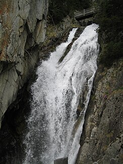
A Salanfe waterfall in the Dailley Gorges |
||
The Salanfe (formerly also Sallanche ) is a creek around seven kilometers long in the canton of Valais in Switzerland .
course
The Salanfe rises on the eastern slope of the Col de Susanfe , a pass between the Haute Cime and the Tour Sallière , at an altitude of around 2470 m and flows through the Lac de Salanfe reservoir (1925 m above sea level), which is also fed by numerous other streams .
After exiting the lake, it flows past the hamlets of Van d'En Haut and Van d'En Bas ( Salvan municipality ) and through the Dailley gorges, which are open to tourists , to Miéville ( Vernayaz municipality ) and forms the Pissevache in the lowest level - Waterfall ⊙ . After 7 kilometers it flows into the Rhone .
Hydropower plants
In 1896–97 the Pissevache hydropower plant was built as a cavern power plant in a cave about 50 meters above the waterfall.
At the end of the 1940s, the Lac de Salanfe was dammed with a gravity dam and a storage power plant was built. Since then, significantly less water has flowed over the waterfall, but instead through pressure pipes from the reservoir to the power plant center in the Rhone Valley .
See also
Web links
Individual evidence
- ↑ Hydrological Atlas of Switzerland of the Federal Office for the Environment FOEN, Table_13
- ^ Geoserver of the Swiss Federal Administration.
- ^ Charles Knapp, Maurice Borel, Victor Attinger, Heinrich Brunner, Société neuchâteloise de geographie (editor): Geographical Lexicon of Switzerland . Volume 4: Plessur - Switzerland . Verlag Gebrüder Attinger, Neuenburg 1906, p. 355 f., Keyword Salanfe ( scan of the lexicon page ).
- ^ Charles Knapp, Maurice Borel, Victor Attinger, Heinrich Brunner, Société neuchâteloise de geographie (editor): Geographical Lexicon of Switzerland . Volume 3: Krailigen - Plentsch . Verlag Gebrüder Attinger, Neuenburg 1905, p. 750 f., Keyword Pissevache ( scan of the lexicon page ).

