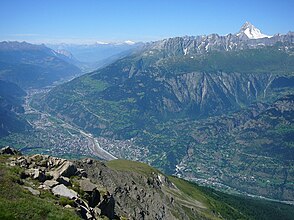
Rhonetal (Switzerland)
| Rhone Valley (Vallée du Rhône) | ||
|---|---|---|
| location | Switzerland / Valais | |
| Waters | Rhone | |
| Mountains | Bernese Alps / Walliser Alps | |
| Geographical location | 596 207 / 119362 | |
|
|
||
| Type | Trough valley | |
| length | 80 km | |
| particularities | Largest wine region in Switzerland | |
The valley of the Rhone from Brig-Glis to Saint-Maurice is called the Rhone Valley (also Walliser Rhone Valley , Swiss Rhone Valley , locally also Rottental ; French Vallée du Rhône ) .
geography
The Swiss Rhone Valley is the main valley of the canton of Valais . It is a trough valley that was formed by the Rhone glacier .
The upstream district of Goms , like the Chablais downstream between Saint-Maurice and Lake Geneva , is not referred to as the Rhone Valley, although these areas are also crossed by the Rhone.
Language areas
In the upper part of the Rhone Valley (and Valais in general) German is spoken, in the lower part French. The language border lies with Sierre ( French: Sierre ).
traffic
The valley is accessible with the main road 9 and the A9 motorway as well as with the railway ( Simplon route ). Through the Lötschberg tunnel with car transport and the Lötschberg base tunnel , the valley can be reached all year round from the Bernese Oberland without having to use the access from Lake Geneva. The valley is connected to Italy via the Simplonpassstrasse and the Simplon railway tunnel as well as the Grosser St. Bernhard Pass and the Grosser St. Bernhard road tunnel .
See also
literature
- Johanna Spyri : In the Rhonethal. Perthes, Gotha 1880.
Web links
- Rhonetal (Switzerland) on the ETHorama platform


