Kymenlaakso
| coat of arms | map |
|---|---|

|
|
| Basic data | |
| Country: | Finland |
| Municipalities: | 7th |
| Administrative headquarters: | Kouvola |
| Surface: | 5,633.09 km² |
| Residents: | 178,497 May 31, 2016 |
| Population density: | 31.7 inhabitants per km² |
| ISO 3166 : | FI-09 |
Kymenlaakso [ ˈkymɛnlɑːksɔ ], Swedish Kymmenedalen , is a landscape ( maakunta ) in Finland . The name comes from the river Kymijoki (Kymmene älv) and means "Kymi valley".
geography
Kymenlaakso is located in southern Finland on the coast of the Gulf of Finland . Neighboring landscapes are Uusimaa in the west, Päijät-Häme in the northwest, South Savo in the north and South Karelia in the northeast. The state border with Russia lies in the southeast .
The area of Kymenlaakso is 5,633 square kilometers, of which 485 square kilometers are inland water. The landscape is shaped by the eponymous Kymijoki River. The northern part of Kymenlaakso is densely forested and rich in lakes, while the southern part is used intensively for agriculture and has little inland water. In the south there is a richly indented archipelago .
There are two urban centers in Kymenlaakso: further north, Kouvola and the incorporated Kuusankoski , which formed an industrial core early on. The trunk road and railroad from Helsinki to Saint Petersburg cross the Kymijoki River here. The Savo Railway branches off from Kouvola to Mikkeli , Kuopio and Kajaani . In the south, on the Baltic coast, lies the port city of Kotka . There is an important freight port there. There is also a passenger ferry to Sillamäe in Estonia and a catamaran connection to St. Petersburg. Hamina is an old garrison town.
history

Today's Kymenlaakso landscape lies in the border area of the historical landscapes of Uusimaa and Karelia . During the Swedish period, the area developed in the shadow of the city of Vyborg (Viipuri), which is now part of Russia . Several manor houses were established for local administration. At the end of the Great Northern War in 1721, the southeastern parts of Finland fell from Sweden to Russia. As a result, the Kymi valley became a border region and Vehkalahti was expanded to become the fortress town of Hamina. After 1743 the border ran along the Kymijoki River. After all of Finland fell to Russia in 1809, the border fortifications lost their importance.
In the 19th century the region experienced strong industrialization. The Kymi River with its rapids and its wooded upper course proved to be favorable for the settlement of sawmills and later paper mills. It served as a transport route for wood and as a source of water energy. Kouvola developed into a traffic junction, so that Kymenlaakso is densely populated by Finnish standards.
After Finland in World War II , to its eastern areas, including Vyborg Soviet Union had lost, which was in 1945 from the remaining parts province of Viipuri the province of Kymi created, which now included the eastern part of Kymenlaakso and South Karelia. Four years later, the municipalities of the Kymi province west of the Kymijoki were also slammed. In 1994 the Kymenlaakso landscape was created through the institutionalization of traditional landscapes. From the provincial reform in 1997 to the dissolution of the provinces in 2009, Kymenlaakso was part of the Province of Southern Finland . Nowadays the region is struggling with the decline of heavy industry, especially the paper industry.
population
Kymenlaakso has around 180,845 inhabitants (as of 2013). Because of the migration to economically more successful regions, the population development is declining. In the early 1990s, Kymenlaaksos had a population of 194,000.
The vast majority of Kymenlaakso's residents are Finnish-speaking . The Finnish-Swedish minority makes up less than one percent of the population. Pyhtää (Pyttis) is the only community in Kymenlaakso that is officially bilingual; she has Finnish as a first language and Swedish as a second language.
coat of arms
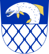
The blazon of the coat of arms of Kymenlaakso reads: In the shield, which is divided by blue and white, there is a white growing fish (salmon) bent to the right with differently colored fins at the top and a blue net at the bottom .
- see also the coat of arms of the Finnish region Kymenlaakso
Communities
There are seven parishes in Kymenlaakso, three of which have city status (in bold). Population figures as of December 31, 2018.
Web links
Individual evidence
- ↑ Tilastokeskus.fi (Finnish Statistics Office), Finnish ( Memento of the original from August 15, 2016 in the Internet Archive ) Info: The archive link was inserted automatically and has not yet been checked. Please check the original and archive link according to the instructions and then remove this notice.
- ↑ Status: January 1, 2009, source: Maanmittauslaitos ( memento of February 25, 2009 in the Internet Archive ) (Finnish land surveying office): Suomen pinta-ala kunnittain January 1, 2009.
- ↑ Statistical Office Finland: Table 11ra - Key figures on population by region, 1990-2018


