
Ångermanälven
|
Ångermanälven Ångermanälv |
||
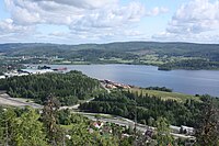
 The river by the city park in Sollefteå |
||
| Data | ||
| location | Västerbottens län , Västernorrlands län ( Sweden ) | |
| River system | Ångermanälven | |
| source | in Børgefjell National Park 65 ° 11 ′ 11 ″ N , 14 ° 10 ′ 46 ″ E |
|
| muzzle | at Ramvik in the Gulf of Bothnia coordinates: 62 ° 48 ′ 0 ″ N , 17 ° 56 ′ 0 ″ E 62 ° 48 ′ 0 ″ N , 17 ° 56 ′ 0 ″ E |
|
| Mouth height |
0 m o.h.
|
|
| length | 490 km | |
| Catchment area | 31,864 km² | |
| Drain |
MQ |
485 m³ / s |
| Left tributaries | Vojmån | |
| Right tributaries | Fjällsjöälven , Faxälven | |
| Flowing lakes | Kultsjön , Malgomaj , Volgsjön | |
| Small towns | Vilhelmina , Sollefteå , Kramfors | |
The Ångermanälven is a river in northern Sweden . It is 490 km long and the most water-rich river in Sweden.
The main source of the Ångermanälven is the Ransarån . This rises in the Børgefjell National Park on the other side of the Norwegian border and flows through the lakes Ranseren and Ransarn before it flows into the Kultsjön . The Ångermanälven is the drain of the Kultsjön. It then flows through Västerbotten , northern Jämtland and Ångermanland in a south-easterly direction, reinforced by numerous tributaries , forming several lakes, including Kultsjön, Malgomaj and Volgsjön . At the port of Nyland the river widens into a 37 km long bay. The Ångermanälven flows north of Härnösand into the Gulf of Bothnia , a bay in the Baltic Sea . Before splitting into the broad estuary around the islands of Åbordsön and Hemsön , Ångermanälven is spanned by the 1,867 m long Högakusten bridge. It is part of the Europastraße 4 . Important tributaries are Vojmån , Fjällsjöälven and Faxälven .
Power plants
Looking downstream, the Ångermanälven is dammed by the following 15 power plants:
| power plant | operator | Installed capacity (MW) |
Opening / renovation |
|---|---|---|---|
| Stalon | Vattenfall | 130.2 | 1961 |
| Malgomaj | Statkraft | 10 | 1983 |
| Volgsjöfors | Statkraft | 20th | 1981 |
| Stenkullafors | Vattenfall | 58 | 1983 |
| Åsele | Vattenfall | 27 | 1981 |
| Hallby | E.ON | 84 | 1970/1992 |
| Gulsele | E.ON | 66.2 | 1954/2008 |
| Degerforsen | E.ON | 63 | 1966 |
| Edensforsen | E.ON | 71.35 | 1956 |
| Långbjörn | Vattenfall | 96.9 | 1960/1992 |
| Lasele | Vattenfall | 149.6 | 1957 |
| Nämforsen | Vattenfall | 114.6 | 1946/1973 |
| Moforsen | E.ON | 135 | 1968 |
| Forsmo | Vattenfall / Statkraft | 160 | 1948/1957 |
| Sollefteå |
Sollefteå Municipality (Sollefteåforsen AB) |
62 | 1966 |
Bollstafjärden

Estuary with Åbordsön island


Web links
Individual evidence
- ↑ Sveriges Meteorologiska och Hydrologiska Institut (SMHI) - Län och huvudavrinningsområden i Sverige (PDF; 2.5 MB)
- ↑ Ångermanälven. vattenkraft.info, accessed May 26, 2016 (Swedish).