Børgefjell National Park
| Børgefjell National Park | ||
|---|---|---|
|
|
||
| Location: | Norway | |
| Next city: | Mo i Rana | |
| Surface: | 1,447 km² | |
| Founding: | August 9, 1963, 1973 and 2003 expanded | |
| The national parks in southern Norway (Børgefjell is number 17) | ||
The Børgefjell National Park ( Norwegian : Børgefjell nasjonalpark , South Sami : Byrkije nasjonalpark ) is Norway's second oldest national park . Founded on August 9, 1963 with an area of around 1000 km² and expanded in 1971 and 2003, it now comprises a protected area of 1,447 km².
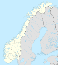
The park belongs to the municipalities of Hattfjelldal , Grane , Namsskogan and Røyrvik , in the provinces of Nordland and Trøndelag . It borders Sweden to the east and the Austre Tiplingan nature reserve to the north .
The Nordland nasjonalparksenter , in the municipality of Saltdal on the E6 , acts as an information center for all national parks in the province of Nordland and thus also for Børgefjell . The next national park is the Lomsdal Visten National Park, established in 2009 .
Geography, geology and landscape
The Børgefjell is part of the Scandinavian Mountains , which formed around 1.7 billion years ago in the Precambrian . The predominant type of rock is granite or gneiss .
The park extends from 270 to 1,699 moh . The landscape is naturally divided into three parts. To the west is a mountain range with the highest peaks in the park. Here is also the highest point, the 1,699 meter high Kvigtinden. The mountains in this part are characterized by black granite. In the east there is a somewhat lower, largely vegetation-free mountain range, characterized by extensive moraines . In between there is a flatter and fertile area with gentle slopes and many lakes and streams.
The largest lakes are the Simskardvatnet and the Orrevatnet . The rivers Jengelvassdraget , Vefsna and Namsen also have their source here.
Flora and fauna

About 300 different plant species are found in the park. The tree line is 500–600 moh. Most of the forest consists of birch trees . Spruce and pine trees are also found here and there.
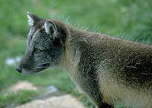
The park is known for the arctic fox , which is found here in significant numbers. The most common predator, however, is the wolverine . Also lynx and brown bears are sighted from time to time in the park. Red fox and arctic fox, mouse weasel , pine marten and ermine live on smaller mammals in the park . The park is also home to a diverse range of birds, which find an ideal habitat in the water-rich and densely vegetated soils of the lowlands. The most common bird of prey is the buzzard . In addition, the park is an important habitat and breeding area for ducks , plovers , other water birds and waders and birds of prey such as the golden eagle and owls such as the snowy owl .
Cultural heritage and current use
Børgefjell has served the Sami as a pasture for their reindeer herds for at least 500 years . This economic use, including the construction of gates, is expressly permitted by the ordinance on the establishment of the park. The oldest evidence of the park's historical importance as a farmland is the remains of huts that the Sami used to sleep.
See also
Web links
- Børgefjell (PDF brochure from thedirectorate for naturforvaltning (since July 2013 Miljødirektoratet ) ; 3.1 MB; Norwegian)
- Om Børgefjell nasjonalpark (information page at Miljødirektoratet ; Norwegian)
- Børgefjell - Fjellrevens fristed (information page at Nordland nasjonalparksenter ; Norwegian)
Individual evidence
- ↑ Arbeidsplass: 1447 kvadratkilometer villmark , nrk.no, accessed on February 23, 2015 (Norwegian)
- ↑ a b Explanations of the history and fauna on the website of the national park administration
- ↑ Forskrift om verneplan for Børgefjell, vedlegg 1, vern av Børgefjell / Byrkije nasjonalpark, Grane, Hattfjelldal, Røyrvik and Namsskogan kommuner, Nordland and Nord-Trøndelag ( Weblink )

