Blåfjella-Skjækerfjella National Park
| Blåfjella-Skjækerfjella National Park | ||
|---|---|---|
|
|
||
| Location: | Trøndelag , Norway | |
| Next city: | Steinkjer | |
| Surface: | 1,924 km² | |
| Founding: | 12/17/2004 | |
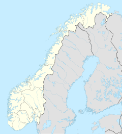
| The national parks in southern Norway (Blåfjella-Skjækerfjella has number 15) | ||
The Blåfjella-Skjækerfjella National Park ( Norwegian : Blåfjella-Skjækerfjella nasjonalpark , South Sami : Låarte-Skæhkere nasjonalpark ) is located in the eastern part of the Trøndelag province and is the third largest national park in Norway .
The park was founded on December 17, 2004 to protect the unmistakable mountain landscape and the primeval forests there. On the same day the Lierne National Park was created a little further east .
In addition to the untouched nature, the park is also intended to protect important habitats for animals and plants, the Sami culture and their cultural heritage. That is why the park is also surrounded by the five nature reserves Skjækra landskapsvernområde , Arvasslia nature reserve , Berglimyra & Klumplifjellet nature reserve , Gaundalsmyra nature reserve and Storfloa nature reserve .
The park is located in the municipalities of Verdal , Steinkjer , Grong , Lierne and parts of Snåsa . In the area of the park there was the 181.5 km² Gressåmoen National Park until 2004 , which became part of the Blåfjella-Skjækerfjella National Park .
Geography, landscape and geology
You can roughly say that the park is bordered by Verdal in the south , Sweden and Lierne in the east , Grong in the north and Snåsa in the west .
The park consists of two almost completely separate areas. The southern part around Skjækerhatten and Skjækerfjella offers large valleys and mountains around 1,000 m - 1,100 m. In the northeast, the Blåfjella area, there are several higher mountains such as the Midtiklumpen , which at 1,333 m is the highest mountain in the park and in the barren area around Gressåmoen , Almedalen and Bukvassfjellet . In the area between the two parts are some (mountain) farms and the lakes Skjelbreien , Gjevsjøen and Holden .
In the southern part of the park there are different types of rock and nutrient-rich soils, which makes for lush vegetation. In the northern part of the park, the soils are not as rich in nutrients, which means that vegetation is sparse. The landscape here changes between primeval forests, deciduous forests, coniferous forests, swamps and mountain ranges.
The mountain Raudfjellet (dt .: Rotberg ) contains a lot of serpentine . Serpentine contains magnesium oxide and iron oxide , which on the one hand gave the mountain its name and on the other hand is a reason for the sparse vegetation around the mountain.
flora
Especially in the north of the park, the landscape is characterized by swamps with sparse vegetation. The most common plants there are rosemary heather , cranberries and leg breakers . One of Norway's first Norway spruces grew in the park . The vegetation in the entire park is, except for a few places, very diverse and ranges from typical coastal plants to mountain plants. Some of the plants are on the red list .
fauna
There are around 30 species of mammals in the park. These include arctic fox , lynx , wolverine and bears . One of the rarest birds in the park is the whimbrel , which lives on some moors. Some of the animals, especially birds, are also on the red list .
heritage Site
Many South Sami have been living in the area around the park for centuries . In Verdal and Snåsa in particular, there are numerous Sami farms and alpine pastures where cattle were raised and some of them still are today.
There are also some alpine pastures in the park, especially between the Swedish border, the Gaundalen valley and the Gjevsjøen .
Tourism and administration
The Lierne nasjonalparksenter in Lierne is the information center for the national park. The state naturoppsyns kontor monitors the park, and also tries to settle reindeer in the park in order to make the park more special and worthy of protection. But there are also good opportunities for fishing and hunting in the area around the park.
The Norwegian Tourist Association (Nord-Trøndelag Turistforening, NTT) maintains the self-catering huts Skjækerdalshytta , Sætertjønnhytta and Bekkstuggu in the park . There are also several mountain huts, some of which can only be used seasonally, at private mountain farms.
See also
literature
- Kristen Krogh: Gressåmoen. In: Den norske turistforenings årbok. 1969, ISSN 0801-5481 .
- Jørn Sandnes, Bjørn Eidissen, Svein Efteland: Gressåmoen (= Norges nasjonalparker. Vol. 5.) Lutherstiftelsens forlag, Oslo 1973, ISBN 82-531-4049-5 .
- Leif Ryvarden: Norges nasjonalparker. 2., opplag med revisjoner. Damm, Oslo 2005, ISBN 82-04-09324-1 .
- Tom Schandy, Tom Helgesen: 100 norske naturperler. Forlaget Tom & Tom, Vestfossen 2008, ISBN 978-82-995682-8-9 , pp. 192-193.

