Rohkunborri National Park
| Rohkunborri National Park | ||
|---|---|---|
| The Sørdalen Gorge in summer | ||
|
|
||
| Location: | Norway | |
| Next city: | Setermoen | |
| Surface: | 571.33 km² | |
| Founding: | 2011 | |
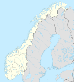
The Rohkunborri National Park ( Norwegian Rohkunborri nasjonalpark ) is a Norwegian national park. It belongs to the municipality of Bardu in the province of Troms og Finnmark . The park covers an area of 571.33 km² and was opened in February 2011 to preserve and protect this large, almost untouched area with its ecosystems and landscapes.
The park borders Sweden in the south and merges into the Swedish Vadvetjåkka National Park in the southwest .
Geography, landscape and geology
The park mainly comprises the southeastern part of the Sørdalen Valley and the mountainous landscape east of it. The highest mountain in the park is the 1659 moh. high raw kunborri . The forest area in the national park is 70.354 km², a part of which is also used for agriculture. In the park are the two larger lakes, Geavdnjajávri and Eartebealjávri .
The landscape is very diverse, so that there is not only natural deciduous forests but also alpine vegetation with lime-rich soils, as well as wetlands and moors.
Flora and fauna
There are some rare animal species in the park, including arctic fox , wolverine , lynx , brown bear , gyrfalcon and snowy owl .
See also
Individual evidence
- ↑ Verneplan for Rohkunborri nasjonalpark ( page no longer available , search in web archives ) Info: The link was automatically marked as defective. Please check the link according to the instructions and then remove this notice. , dirnat.no, accessed on May 4, 2011 (PDF, Norwegian)
- ↑ a b Data sheet about the Rohkunborri National Park , regjeringen.no, accessed on May 4, 2011 (PDF, Norwegian; 527 kB)

