
Nordvest Spitsbergen National Park
| Nordvest Spitsbergen National Park | |
|---|---|
 |
|
 |
|
| Location: | Svalbard , Norway |
| Next city: | Longyearbyen |
| Surface: | 9,873 km² |
| Founding: | June 1, 1973 |
The Nordvest-Spitsbergen National Park ( Norwegian Nordvest-Spitsbergen nasjonalpark ) is a 9,914 km² national park in the Norwegian archipelago of Spitsbergen . It includes areas in the northwest of the island of Spitzbergen ( Albert-I-Land and Haakon-VII-Land ) as well as offshore islands such as Danskøya, Amsterdamøya, Nordvestøyane and Moffen . A total of 3,684 km² of mainland and 6,189 km² of sea area belong to the national park, which is one of seven in the Svalbard archipelago. It was founded in 1973.
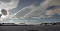
In the Nordvest Spitsbergen National Park there is a contrasting landscape with mountains, glaciers, islands and bays. There are also hot springs in the park. In the national park are also the ruins of the abandoned Dutch whaling settlement Smeerenburg from the 17th century.
On the west coast in Signehamna on Lilliehöökfjord in Nordvest-Spitsbergen National Park are the former German weather stations of the Wehrmacht Knospe / Nussbaum, in the north on Liefdefjord the weather station Kreuzritter.
Picture gallery

Smeerenburg
Lilliehöökfjorden

Lilliehöökfjorden

.jpg)
.jpg)
,_Fuglesangen,_Svalbard.jpg)
See also
Web links
Mainland
Blåfjella-Skjækerfjella |
Breheimen |
Børgefjell |
Dovre |
Dovrefjell-Sunndalsfjella |
Færder |
Femundsmarka |
Folgefonna |
Forollhogna |
Fulufjellet |
Gutulia |
Hallingskarvet |
Hardangervidda |
Yomfruland |
Jostedalsbreen |
Jotunheimen |
Junkerdal |
Láhko |
Langsua |
Lierne |
Lofotodden |
Lomsdal-Visten |
Møysalen |
Raet |
Rago |
Reinheimen |
Reisa |
Rondane |
Rohkunborri |
Saltfjellet-Svartisen |
Seiland |
Sjunkhatten |
Skarvan and Roltdalen |
Stabbursdalen |
Varangerhalvøya |
Ytre Hvaler |
Øvre Anárjohka |
Øvre Dividal |
Øvre Pasvik |
Ånderdalen
Svalbard (Spitzbergen)
Forlandet |
Indre Wijdefjorden |
Nordenskiöld Land |
Nordre Isfjorden |
Nordvest-Spitsbergen |
Sassen-Bünsow-Land |
Sør-Spitsbergen
former
Gressåmoen |
Ormtjernkampen