
Sør Spitsbergen National Park
| Sør Spitsbergen National Park | |
|---|---|
 |
|
| Location: | Svalbard , Norway |
| Next city: | Longyearbyen |
| Surface: | 13,286 km² |
| Founding: | June 1, 1973 |
.jpg) |
|
The Sør-Spitsbergen National Park ( Norwegian Sør-Spitsbergen nasjonalpark ) is a 13,286 km² national park on the Norwegian island of Spitsbergen . The national park covers 5,029 km² mainland and 8,257 km² sea area. The park is one of seven national parks on Svalbard.
It was founded in 1973. The landscape is characterized by striking, pointed rock formations. The Hornsund - Fjord is an important habitat for polar bears .
The southern third of the national park is taken by Sørkapp Land .
Picture gallery

Polar bear on Hornsund
Polish research station on Hornsund

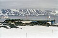
Horyzont II at Isbjørnhamna
_1.jpg)
.jpg)

See also
Web links
- Miljødirektoratet: Official website of the national park
- Sør-Spitsbergen nasjonalpark . In: The Place Names of Svalbard (first edition 1942). Norsk Polarinstitutt , Oslo 2001, ISBN 82-90307-82-9 (English, Norwegian).
Mainland
Blåfjella-Skjækerfjella |
Breheimen |
Børgefjell |
Dovre |
Dovrefjell-Sunndalsfjella |
Færder |
Femundsmarka |
Folgefonna |
Forollhogna |
Fulufjellet |
Gutulia |
Hallingskarvet |
Hardangervidda |
Yomfruland |
Jostedalsbreen |
Jotunheimen |
Junkerdal |
Láhko |
Langsua |
Lierne |
Lofotodden |
Lomsdal-Visten |
Møysalen |
Raet |
Rago |
Reinheimen |
Reisa |
Rondane |
Rohkunborri |
Saltfjellet-Svartisen |
Seiland |
Sjunkhatten |
Skarvan and Roltdalen |
Stabbursdalen |
Varangerhalvøya |
Ytre Hvaler |
Øvre Anárjohka |
Øvre Dividal |
Øvre Pasvik |
Ånderdalen
Svalbard (Spitzbergen)
Forlandet |
Indre Wijdefjorden |
Nordenskiöld Land |
Nordre Isfjorden |
Nordvest-Spitsbergen |
Sassen-Bünsow-Land |
Sør-Spitsbergen
former
Gressåmoen |
Ormtjernkampen