
Names
| Names | ||
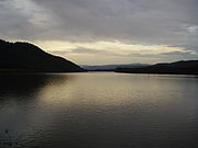
 The Namsen near Kvatningen in the municipality of Overhalla, about 10 km from its confluence with the Namsenfjord |
||
| Data | ||
| Water code | NO : 139th time | |
| location | Trøndelag ( Norway ) | |
| River system | Namsenvassdraget | |
| Drain over | Namsen → Atlantic Ocean | |
| source | At Røyrvik | |
| muzzle | At Namsos in the Namsenfjord coordinates: 64 ° 27 '28 " N , 11 ° 30' 33" E 64 ° 27 '28 " N , 11 ° 30' 33" E |
|
| Mouth height |
0 m
|
|
| length | 228 km | |
| Catchment area | approx. 6.298 km² | |
| Drain |
MQ |
155 m³ / s |
| Small towns | Namsos | |
| Communities | Røyrvik , Namsskogan , Grong , Overhalla , Namsos | |
The Namsen ( South Sami : Nååmesje ) is a river in Trøndelag in Norway . It arises near the Swedish border in the area of the municipality of Røyrvik , where it forms the drain of Lake Store Namsvatn . It flows through the Namdalen valley for a length of 228 kilometers, essentially in southern and western directions, before it flows into the Namsenfjord in Namsos . Its two main tributaries are Bjøra and Sanddøla . The river flows through the municipalities of Røyrvik, Namsskogan , Grong , Overhalla and Namsos.

The water flow of the Namsen varies greatly, it often falls below 200 m³ / s, but also reaches over 1000 m³ / s. It is one of the best rivers in Norway for fishing. The main fish species are salmon and trout . It is regulated by several dams with fish ladders. Numerous anglers come every year, especially from Denmark , Sweden and Germany . Numerous whooper swans live on the Namsen, the majority of which have recently stayed there in winter.
Regulated lakes in the catchment area
| Surname | Storage volume in million m³ |
Area in km² |
min. Height in moh |
Max. Height in moh |
Regulation height in m |
|---|---|---|---|---|---|
| Namsvatnet | 458 | 39.4 | 440 | 454 | 14th |
| Vectors | 39 | 9.2 | 440 | 445.5 | 5.5 |
| Limingen | 260 | 93.5 | 309 | 417 | 8.7 |
| Tunnsjøen | 440 | 100.2 | 352 | 357 | 5 |
| Tunnsjøflyan | 13 | 7.1 | 345 | 348 | 3 |
Hydroelectric power plants in the catchment area
| Surname | completion position |
Power in MW |
Annual output in GWh |
Fall height in m |
Number of turbines |
Reservoir | operator |
|---|---|---|---|---|---|---|---|
| Nedre Fiskumfoss power sales | 1955 | 39 | 240 | Nord-Trøndelag Elektrisitetsverk | |||
| Øvre Fiskumfoss power sales | 1976 | 7.6 | 57 | 3 | Nord-Trøndelag Elektrisitetsverk | ||
| Aunfoss power sale | 1979 | 28 | 180 | 2 | Nord-Trøndelag Elektrisitetsverk | ||
| Åsmulfoss power sales | 1971 | 12 | 74 | Nord-Trøndelag Elektrisitetsverk | |||
| Tunnsjødal Kraftverk | 1962 | 176 | 820 | Tunnsjøflyan | Nord-Trøndelag Elektrisitetsverk | ||
| Røyrvikfoss power sales | 1965 | 16 | 96 | Vectors | Nord-Trøndelag Elektrisitetsverk | ||
| Tunnsjø Kraftverk | 1963 | 82 | 138 | Limingen | Nord-Trøndelag Elektrisitetsverk | ||
| Tunnsjøfoss power sales | 27 | Tunnsjøen | Nord-Trøndelag Elektrisitetsverk | ||||
| Linvasselv power sales | 1962 | 68 | 200 | 108 | Limingen | Nord-Trøndelag Elektrisitetsverk, E.ON Sverige AB |

The Namsen, seen from Kvatningenfjell, with Namsos in the background
Namsen between Skage and Kvatningen
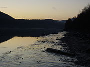
Evening mood on the Namsen at low tide

The disused Grong – Namsos railway line


See also
swell
- 1. Geographical information: Wikipedia article in Norwegian (Bokmål) and English, maps and atlases
- 2. Water supply: http://www2.nve.no/h/hd/plotreal/Q/0139.00017.000/index.html
- 3. Fisheries: Wikipedia article in Norwegian (Bokmål) and English
- 4. Whooper Swans: Oral Reports from Locals