Scandinavian mountains
| Scandinavian mountains / Scandinavia | |
|---|---|
| Highest peak | Galdhøpiggen ( 2469 moh. ) |
| location | Norway , Sweden , Finland |
| part of | Scandinavia |
| Coordinates | 65 ° N , 14 ° E |
| Age of the rock | Precambrian - Devonian |
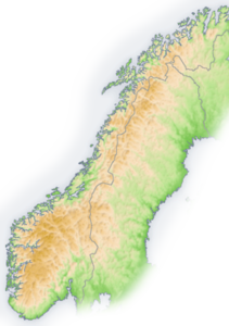
The Scandinavian Mountains (also called Skanden , Swedish Fjällen , Norwegian Kjølen ; formerly Scandinavian Alps ) is a mountain range that runs through the Scandinavian Peninsula from the Norwegian Skagerrak coast in the south to the North Cape . It has a length of about 1700 km and a maximum width of 320 km. Norway and Sweden and to a very small part in the north also Finland have a share in the mountains. Along the Finnish eastern border to the south extends the flattening foothill Maanselkä , in which Russia also participates. The mountain range in its northern part on the border between Norway and Sweden is also the Scandinavian watershed. In the Norwegian sub-mountains Jotunheimen , the Skanden reach the highest point in Northern Europe and Norway with the 2,469 m high Galdhøpiggen . In Kebnekaise , 2111 m, they also represent the highest mountain in Sweden and in Haltitunturi , 1324 m, the highest mountain in Finland.
The term Fjell is used in Scandinavia not only for the Scandi, but also generally as a term for high mountains or mountain tundra .
Emergence
The rocks of the Scandinavian Mountains represent a part of the Caledonian Mountains, which were unfolded in the course of the collision between “Ur-North America” (Laurentia) and “Ur-Europe” (Baltica). This collision occurred approximately 440 or 430 to 390 million years ago (early Silurian to mid Devonian ) and is known as the Scandic phase of the Caledonian orogeny . These mountains were subsequently more or less completely leveled by erosion .
Today's Scandinavian Mountains are the result of an uplift of the old Caledonian deformed crust in the Tertiary . There are various hypotheses about the cause of this increase. The Scandinavian Mountains are interpreted, among other things, as the rift shoulder of the North Atlantic Rift or attributed to tectonic tensions within the Western Eurasian crust as a result of a general global change in plate movements. Significant negative gravity anomalies in the Scandinavian Mountains, however, indicate isostatic uplift, which may be associated with moderate heating and, as a result, a loss of density in the Caledonian deformed crust. The Iceland hotspot is assumed to be the source of heat .
Relief and vegetation

The Skanden reach an altitude of 2469 m (Galdhøpiggen), but in some areas they only have the character of a low mountain range . Due to the deformation by the Ice Age glaciers, the high mountain areas, unlike the other European high mountains, often have round, soft shapes (glacier cut), less pronounced peak shapes. The heights of the mountains are partly formed in plateaus, which are cut by deep, steeply sloping valleys. During the Ice Age, the Scandinavia was almost entirely buried under a 1500 meter thick layer of ice. After the ice load had thawed, uplift began and continues to this day.
While the Scandinavian Mountains drop in steps to the east, the west side is characterized by a steep, deeply divided drop. The ice age reshaping also resulted in numerous fjords on the west side with the trough shape typical of glacial valleys.
Parts of the Skanden are covered by plateau glaciers , the foothills of which extend almost down to sea level (e.g. Engenbreen, +10 m). The largest are Jostedalsbreen (with approx. 486 km² the largest glacier in continental Europe), Svartisen and Folgefonna .
With the exception of a small subpolar proportion, the Scandi lie in the boreal ecozone , so that the vegetation below the foot of the mountain consists of boreal coniferous forests . The forest and tree line - unlike in most other mountains on earth - is formed by the mountain birch . Above it lies the treeless fjell , which consists of dwarf shrub heaths, mountain meadows, meadows and moors, as well as rubble heaps with moss and lichens in the summit regions.
View from Kebnekaise (2110 m) over the mountains of Lapland
The Tarfala basin ( Kebnekaise area) with the Kaskasapakte glacier and the Kaskasapakte summit (2043 m)
Web links
Individual evidence
- ^ Scandinavian Alps. In: Pierer's Universal-Lexikon , Volume 16, fourth edition, Altenburg 1863, p. 162
- ↑ David G. Gee, Haakon Fossen, Niels Henriksen, Anthony K. Higgins: From the Early Paleozoic Platforms of Baltica and Laurentia to the Caledonide Orogen of Scandinavia and Greenland. Episodes. Vol. 31, No. 1, 2008, pp. 44–51, ( PDF 860 kB)
- ^ A. Ladenberger, DG Gee, Y. Be'eri Shlevin, S. Claesson, J. Majka: The Scandian collision revisited - when did the orogeny start? In: Geophysical Research Abstracts , Vol. 14, EGU2012-12633, 2012 ( PDF 39 kB)
- ↑ TF Redfield, PT Osmundsen, BWH Hendriks: The role of fault reactivation and growth in the late uplift of western Norway. Geophysical Research Abstracts, Vol. 7, 03025, 2005, SRef-ID: 1607-7962 / gra / EGU05-A-03025 ( PDF 34 kB). A comprehensive article by the same authors with an identical title has appeared in the Journal of the Geological Society (London), Vol. 162, No. 6, 2005, pp. 1013-1030, doi : 10.1144 / 0016-764904-149 .
- ↑ S. Cloetingh, FM degree Stein, H. Kooi, AC Grant, M. Kaminski: Plate reorganization: a cause of rapid late Neogene subsidence and sedimentation around the North Atlantic? In: Journal of the Geological Society (London), Vol. 147, No. 3, 1990, pp. 495-506, doi : 10.1144 / gsjgs.147.3.0495 ( alternative download PDF 1.2 MB).
- ↑ Christophe Pascal, Odleiv Olesen: Are the Norwegian mountains compensated by a mantle thermal anomaly at depth? Tectonophysics. Vol. 475, No. 1, 2009, pp. 160-168, doi : 10.1016 / j.tecto.2009.01.015 . Note: This work contains a short outline of the numerous hypotheses that caused the uplift of the Scandinavian Mountains.


