
Svartisen
| Svartisen | ||
|---|---|---|
 Svartisen from the air from the west |
||
| location | Nordland ( Norway ) | |
| Mountains | Scandinavian mountains | |
| surface | 370 km² | |
| Coordinates | 66 ° 38 ′ N , 14 ° 0 ′ E | |
|
||

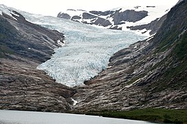
Svartisen ( Norwegian for "the black ice") is the second largest glacier in Norway with 370 km² and is located in the province (Fylke) Nordland , just above the Arctic Circle in the Saltfjellet-Svartisen National Park northwest of the city of Mo i Rana . It has a total of 60 glacier arms. The Glom Valley lies between the two main glaciers, the East (Østertaleis) and the West Ice .

Engabreen, Svartisen, Norway (2004)

Engabreen and Holandsfjord (2005)

Glacier tongue (2003)
Glacier tongue (2017)

The Rana glacier tongue on Svartisvatnet


.jpg)

history
The Østertal ice was divided into two arms of the glacier around 1900. The eastern one extended into the Svartis Glacier Lake. Over the course of the next 50 years, the glacier receded considerably and no longer reached the lake. In 1910 the glacier front was only 50 m away from the glacier lake, in 1945 it was already 1000 m. The retreat of the glacier created a glacier lake on the western edge of the glacier arm . As the ice continued to recede, the lake grew larger every year. The meltwater of the glacier originally flowed in a westerly direction under the ice into the Svartis Glacier Lake and out through the Røvasstal. This led to numerous floods in the summer , which caused great damage. The problem was solved in 1959 with the completion of a tunnel. This enables the controlled drainage of the melt water . The mouth of the tunnel can be visited on the way from the Svartis Glacier Lake to the glacier. In 1982 the Østertal ice extended over the entire basin, where the Østertal glacier lake is today. The ice ended in the valley floor in the southern part of the basin. In July 1982 the lower part of the glacier arm broke off. In the course of only one week, the glacier edge retreated over 100 m above the water. In June 1987, a large part of the arm of the glacier that was still loosely in the water after the major fall calved. Global warming is believed to be the main cause of the retreat, but the retreat of the glacier before the Second World War suggests that other causes are possible.
sightseeing
The Svartisen Glacier is easy to reach from Mo i Rana . A road leads through the Røvasstal up to the Svartisen Glacier Lake. During the summer season it is possible to take a boat across the fjord. The crossing takes 15 minutes. Then you can walk up to the Østertal glacier lake and the glacier tongue on a well-marked, approx. 4 km long hiking trail.
literature
- Grønligrotta - Setergrotta - Svartisen . Polarsirkelen Reiselisvlag, Mo i Rana - German edition from 1994.
various loose information sheets of the tourist information of the city Mo i Rana without further information
Web links
- schwarzaufweiss.de
- www.svartisen.no
- Photos and information about Svartisen - Fjordblick.com