Skagerrak
| Skagerrak | |
|---|---|
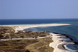
| View from Skagens lighthouse to the northwest: the Grenen headland in the middle distance , the Skagerrak behind, and the Kattegat on the right | |
| Connects waters | Kattegat |
| with water | North Sea |
| Separates land mass | Scandinavia |
| of land mass | Jutland |
| surface | 47,000 km² |
| Data | |
| Geographical location | 57 ° 51 ' N , 9 ° 4' E |
| length | 240 km |
| Smallest width | 140 km |
| Greatest depth | 700 m |
| Coastal towns | Oslo , Kristiansand |
The (or the) Skagerrak is part of the North Sea between the north coast of Jutland (Denmark), the south coast of Norway and the north west coast of Sweden .
location
The Skagerrak is the geographical area bounded in the west by a line from the lighthouse of Hanstholm to the lighthouse of Lindesnes and in the south by a line from the lighthouse of Skagen to the lighthouse of Tistlarna and from there to the next point on the Swedish coast (Art. 4 lit.b of Regulation (EU) 2020/123 ). It therefore connects the North Sea with the Baltic Sea via the Kattegat (east side of Jutland), the Great and Little Belt and the Öresund . It is named after Skagen at the northernmost end of Jutland; the Dutch word rak means something like “straight waterway”.
The transition between the Skagerrak and Kattegat sea areas lies on the line of the tip of the Grenen peninsula (Skagen, Denmark) northeast over to Paternoster Skär (north of Gothenburg , Sweden). The western end of the Skagerrak is formed by the line Hanstholm (Denmark) - Cape Lindesnes (Norway).
The Skagerrak is 240 km long and between 80 km and 140 km wide. It gets deeper and deeper towards the Norwegian coast and reaches a depth of over 700 m in the Norwegian channel (near Arendal ). The Skagerrak has a salinity of 30 PSU.
Transport, infrastructure
The Skagerrak is a heavily traveled sea area due to its connection function between the North Sea and the Baltic Sea. However, the transition between these two seas can be shortened considerably by using the Kiel Canal for ships that do not exceed a maximum length of 235 meters . Important seaports on the Skagerrak are Hirtshals in Denmark, Kristiansand , Larvik , Sandefjord , Tønsberg , Oslo and Moss in Norway and Strömstad and Uddevalla in Sweden.
Due to the transport of crude oil from the Russian transshipment ports Vysotsk , Primorsk and Saint Petersburg to Western Europe, numerous large tankers also use the Skagerrak. Some of the world's largest container ships also pass through the Skagerrak to the destination ports of Gothenburg and Aarhus .
The Skagerrak is known in seafaring for its difficult sea conditions from wind and swell , depending on the weather .
The high-voltage direct current transmission line HVDC Cross-Skagerrak between Denmark and Norway crosses the Skagerrak.
Important ferry connections across the Skagerrak:
- Hirtshals (DK) - Kristiansand (N) ( Color Line , Fjord Line ),
- Hirtshals (DK) - Larvik (N) (Color Line),
- Sandefjord (N) - Strömstad (S) (Color Line, Fjord Line)
- Oslo (N) - Frederikshavn (DK) ( Stena Line ).
Major international ferry routes lead across the Skagerrak:
- Oslo (N) - Kiel (D) (Color Line)
- Oslo (N) - Copenhagen (DK) ( DFDS )
- Hirtshals (DK) - Stavanger (N) - Bergen (N) (Fjord Line)
Acts of war and the post-war period
End of May 1916 took place on the western exit of this sea area, the largest and richest loss naval battle of World War I , the Battle of Jutland (English Battle of Jutland instead). After this battle, numerous streets, bridges and squares were named during the Weimar Republic and the Nazi era .
Because of the great depth of the sea in this sea area, the Allies sank more than 50 ships loaded with chemical weapons there after the Second World War , including the Düsseldorf and Herbert Norkus . In 2002 a Norwegian Navy research institute examined some wrecks.
Web links
Individual evidence
- ↑ Nudansk Ordbog. 15th edition. Politics Forlag, Copenhagen 1993. Keyword Skagerrak .
- ^ The store Danske Encyklopædi. CD-ROM. Gyldendal, Copenhagen 2004. Keyword Skagerrak .
- ↑ City of Boston SS (1921 ~ 1927) Patagonia SS? († 1945) , wrecksite.eu, accessed on May 7, 2013.
- ↑ Sammanfattning av kunskaperna kring miljö riskerna med läckande vrak i Skagerrak (PDF; 1.7 MB), projektwebbar.lansstyrelsen.se, accessed on May 7, 2013.
- ↑ Investigation and risk assessment of ships loaded with chemical ammunition scuttled in Skagerrak. (PDF (4.2 MB)) November 2002, accessed on May 27, 2014 (English).

