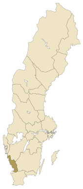
Halland
| Halland | |
|---|---|

|

|
| Basic data | |
| Part of the country (landsdel) : | Götaland |
| Province (län) : | Hallands Lan |
| Surface: | 4,954 km² |
| Residents: | 300,510 (December 31, 2008) |
| Population density: | 59 inhabitants per km² |
| Highest elevation: | Högalteknall 226 m ö.h. |
| Largest lake: | Lygners |
Halland is a historical province ( Swedish landskap ) in Sweden , on the coast of the Kattegat .
geography
In the south Halland bordered by Scania (Skane) , wherein the Hallandsås forms the natural parting line. Småland joins in the east with the southern Swedish highlands as a separation zone. In the north lies Västergötland with the city of Gothenburg . Up until the 13th century, the Göta älv river was the natural dividing line here. As the population in Västergötland increased, the border was moved further south.
Halland used to consist of eight Harden , these are no longer of administrative importance today. The towns of Laholm , Halmstad , Falkenberg , Varberg and Kungsbacka lie along the coast from the south . Halland's largest rivers are the Viskan , Ätran , Nissan and Lagan .
history
The area was populated during the Stone Age . More than 1,100 archaeological finds are known from this period, such as dolmens (Swedish dös ), passage graves , burial mounds , roes and stone setting mostly in burial fields such as the burial ground of Örelid . There are six passage graves in Halland, three of them in the northern and three in the southern part of the province. Towards the end of the era the landscape was used intensively and large areas became treeless. During the transition from the Bronze Age to the Iron Age , the region's climate cooled and the existing social system collapsed. After an initially sluggish development, various villages formed larger communities and smaller kingdoms emerged. The large individual farmsteads built around the year 400 continued to grow and their number decreased. One of these large farms was excavated in the village of Slöinge .
From the reports of the merchant Ottar , who was traveling between the Oslofjord and Haithabu around 870 , it can be concluded that Halland was Danish territory during this time . During this time the legal system of the province of Skåne was applied and the negotiations ( Ting ) took place in Getinge .
From the 13th century, Halland was the theater of war for several battles, mainly between Sweden and Denmark. The many wars left the region impoverished. This happened on the one hand because of the extensive destruction and on the other hand because the population invested little in the area, as there was always the risk of renewed destruction. Three major looting contributed to this development. The first happened in 1256 under the Norwegian King Håkon IV , the second in 1277 under the Swedish King Magnus I and the last in 1294 under the Danish King Erik VI. In the following time Halland was divided into two parts with the river Ätran as a border. The ownership changed often until Waldemar IV. Reunited the region.
With the Kalmar Union , Halland was suddenly at the center of the Danish Empire and, according to the Union Treaty, Erich von Pomerania should have been crowned in Halmstad. In the following years Halland was not spared from the wars of the epoch. The landscape was conquered by fighters of the Engelbrekt uprising in 1434 and the Falkenberg castle was sacked. In the course of the Three Crowns War , the Battle of Axtorna (also: Battle on the Falkenberger Haide) took place here in 1565, in which the Danish general Rantzau defeated a superior Swedish army.
Halland belonged to Denmark until 1645 and was then awarded to Sweden for 30 years in the Peace of Brömsebro . Since the Peace of Roskilde in 1658 Halland has finally belonged to Sweden, although Denmark tried again in the Skåne War (1675–1679) to recapture lost territory.
With the arrival of peaceful conditions, Halland was able to develop again. There were contradictions between regions that were used intensively for agriculture and forest zones, which were still provincial and poor. In addition, soil erosion and sandy heather made some areas unattractive, so that many people emigrated into the 20th century .
After the Second World War , the landscape changed significantly. The population increased from about 150,000 (1945) to over 300,000 (2005) and Halland went from an agricultural province to an industrialized zone. The northern area became important as a place of residence for commuters to Gothenburg.
coat of arms
Description: In blue a silver, red armored and red tongued lion .
Landscape symbols
- Flower: hairy gorse
- Animal / fish: salmon
- Vogel: Peregrine falcon
Web links
- Official website (Swedish, English, German, Danish, Norwegian)
Individual evidence
- ↑ Folkmängd i landskapen on December 31, 2008. In: Statistiska centralbyrån. August 13, 2009, archived from the original on August 17, 2013 ; Retrieved December 12, 2018 (Swedish).
- ^ Märta Strömberg : The megalithic graves of Hagestad: on the problem of grave structures and grave rites (= Acta archaeologica Lundensia, 9). Habelt, Bonn / Gleerup, Lund, 1971, ISBN 978-3-7749-0195-7 , p. 198.