Lapland (historical province)
| Lapland | |
|---|---|

|

|
| Basic data | |
| Part of the country (landsdel) : | Norrland |
| Province (län) : | Norrbotten County , Västerbotten County |
| Surface: | 118,206 km² |
| Residents: | 95,105 (December 31, 2008) |
| Population density: | <1 inhabitant per km² |
| Highest elevation: | Kebnekaise (2,111 m) |
| Largest lake: | Torneträsk |
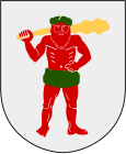
Lapland is a historical province ( Swedish landskap , therefore often translated as 'landscape') in Sweden . Your landscape symbols are the white silver arum and the arctic fox .
geography
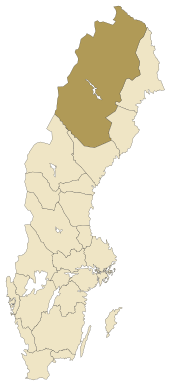
The historic province borders Norway to the west, Finland to the north and east , Norrbotten to the southeast and Jämtland to the south . It forms the west of the present-day provinces of Norrbottens län and Västerbottens län . The largest places are Kiruna and Gällivare .
The very sparsely populated Fjäll landscape rises gradually from east to west and reaches heights of over 2,000 meters on the Swedish-Norwegian border ( Kebnekaise , Sarek , Akka ).
history
In the 17th century, large parts of today's Norwegian Finnmark also belonged to Swedish Lapland. It was not until 1826 that the border between Russia and Norway was drawn. The southern part of Lapland belonged entirely to Sweden until 1809. In 1809 the Grand Duchy of Finland - and with it what is now the Finnish part of Lapland - was ceded to Russia and today's borders were drawn.
See also
Web links
Individual evidence
- ↑ Folkmängd i landskapen ( Memento from August 17, 2013 in the Internet Archive )