Sarek National Park
| Sarek National Park | ||
|---|---|---|
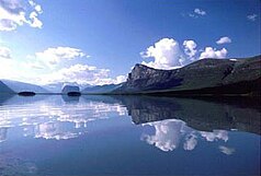
| View from the summit of Skierfe to the west into the valley of the Rapaätno with the Inselberg Namatj in the central part of the Sarek National Park | ||
|
|
||
| Location: | Sweden | |
| Next city: | Gällivare , Jokkmokk | |
| Surface: | 1970 km² | |
| Founding: | 1909 | |
| View of the Sarek National Park from Lake Laitaure in the Rapadalen with Skierfe on the right, Nammatj in the center | ||
| Tent at Ruohtesjávrásj in western Sarek National Park | ||
| The Ålkatj massif as seen from Snávvávágge | ||
| Bierikjåhkå valley in Sarek National Park with a view to the southwest | ||
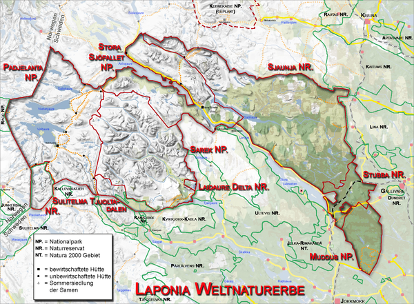
The alpine mountain landscape of the Sarek is a national park in the Swedish part of Lapland ( Sami Sápmi ). In tourism jargon it is sometimes referred to as “ Europe's last wilderness ”, although this is far from being the case. Even other areas in Sweden (such as the larger, largely pathless nature reserve Sjaunja ) deserve this rating better than the Sarek because of their remoteness and inaccessibility. Together with the national parks and nature reserves Muddus , Stubba , Sjaunja, Stora Sjöfallet , Padjelanta and Tjuolda , it is part of the UNESCO World Heritage Site " Laponia ".
description
The landscape of Sarek is part of the seeds used reindeer breeding areas in Lapland. In winter they stayed in the forest landscapes east of the Sarek, while in summer they moved with the reindeer herds through the valleys of today's national park to the west on the Padjelanta plateau (Sami: "upper land"). The roads used by the Sami led in the Sarek through the Njoatosvágge, the Guhkesvágge, the Ruohtesvágge and the Guohpervágge. On the other hand, Rapadalen was not suitable as a transit area because of its difficult accessibility. Even today there are individual reindeer watchmen's huts in the area of the Sarek. Smaller huts were closed and larger ones built to make room for more people. These huts are usually locked.
The Sarek was systematically researched at the beginning of the 20th century by the geographer Axel Hamberg (1863–1933), to whom it is also thanks that the Sarek was declared a national park in 1909. This saved the untouched northern landscape from the exploitation efforts of the Swedish hydropower plant companies. These had previously regulated or dammed many of the rivers in Norrland. Hamberg spent every summer in Sarek for 37 years, researching the climatic and geological conditions as well as the flora. He developed tin huts, which he had set up at five different locations in Sarek in order to set up observation and research stations. Some of the tinworks are still in their original locations today (one is near the Rapaälv, east of the Nammásj). One of these huts was set up in the mountain botanical garden ( Fjällbotaniska trädgård ) in Jokkmokk and can be viewed there. Axel Hamberg also wrote the first tourist guide on the Sarek, which was published in 1922 by Svenska Turistföreningen . More recently, the Sarek has been described in hiking guides by, among others, photographer Claes Grundsten.
The extension of the national park is roughly circular and has a diameter of about 50 km. The varied landscape consists of deeply cut valleys, some plateaus and rugged mountain ranges and glaciers. The most important mountain ranges include the Ähpár group (1871 m), the Sarektjåhkkå (2089 m), the Ålkatj (1937 m), the Rouhtes (1988 m), the Pårte massif (2005 m) and the Skårki (1810 m). The valleys are overgrown with birch forests in the lower part (in the east). Bierikjávrre is one of the most beautiful glacial lakes in Sarek . Most of the rivers in Sarek flow from west to east and form the headwaters of the Luleälv , which flows into the sea at Luleå .
There are no accommodations in the park, no marked paths and only four bridges, e.g. B. in the center of the park at Skarja over the Smájllájåhkå and over the glacial river Guhkesvákkjåhkå . It is the rainiest area in Sweden, which you have to be prepared for when hiking. The greatest danger in summer is wading through raging streams. The highest mountains are around 2000 m high and are seldom climbed because of the long approach.
In Sarek's famous valley of lies Rapaätno . The river delta lies outside the national park border, but is one of the most beautiful natural sights in Europe. However, there have long been efforts to expand the national park to include this area. These became more specific in summer 2007. From the summit of Skierffe you can see this glacial trough valley. A worthwhile viewpoint of the Rapaädno is on the Låddebákte (about two days' walk from Aktse). From here you can see the Rapaselet below the mouth of the Sarvesjåhkå in the Rapaädno . In the widened part of the valley here, the river forms numerous lagoons and meanders strongly. The spot is preferred by the Sarek moose, which is why you can watch numerous moose here in the evening and in the morning, grazing in the shallow water. In Rapaselet there is also the so-called Rovdjurstorg (predator place), so named because traces of all four predators that live in Sarek were found here in one morning: bear , wolverine , lynx and arctic fox .
The ruins of the historic Alkavare Chapel were reconstructed in 1961.
Access
The national park is difficult to access. The nearest cities are Gällivare (18 hours by night train from Stockholm) and Jokkmokk (bus connection from Murjek train station). The busiest starting points for hikes are Kvikkjokk and Ritsem and the Saltoluokta mountain station . The Kungsleden long-distance hiking trail touches the southeastern tip of the park. In late winter (March – May), it is easier to get around in many places because many bodies of water are frozen over. On the other hand, the luggage is more extensive than in summer and a winter tour in remote areas requires sufficient experience.

swell
- ^ Igor Lysenko et al. Christoph Zockler: The 25 Largest Unfragmented Areas in the Arctic. A report produced by UNEP-WCMC and UNEP / GRID-Arendal for WWF Arctic Program, pdf version , December 2001. P. 64 (Bolshezemelskaya Tundra), 74 (Novaya Zemlya), 82 (Svalbard), 89 (Kola Peninsula), 107 (Malazemelskaya Tundra).
- ↑ Frank Baldus: Sjaunja - The wisdom of the wilderness. An almost unsuccessful trekking trip . Nunatak-Verlag, Wuppertal 1997, ISBN 3-935694-00-8 , pp. 227-229.
- ↑ Naturvårdsverket (2007): National Park Plan for Sverige - Utkast och remissversion ( PDF ( page no longer available , search in web archives ) Info: The link was automatically marked as defective. Please check the link according to the instructions and then remove this notice. )
literature
leader
- Rebecca Drexhage and Benjamin Hell: "Sarek". Conrad Stein Verlag, Welver 2007, ISBN 978-3-86686-017-9 .
- Joel Karlberg, Petter Lämås and Josef Larsson: Sarek vinterguide, Stockholm 2010, ISBN 978-91-978180-2-5 .
- Claes Grundsten: Sarek, turbeskrivningar . Stockholm 2000.
German translation Sarek - Trekking in Sweden: hiking guide , Reise Know-How Verlag 2011, ISBN 978-3-8317-2087-3 . - Axel Hamberg: Sarekfjällen, vägledning för färder i Högfjällen mellan Lule älvs källarmar . 1922.
Descriptions
- Karl-Erik Forsslund: Fridlysta vildmarker, skildringar och historier från Sverges [sic!] National park . Stockholm 1915.
- Naturvårdsverket (ed.): Lapplands världsarv . Stockholm 1997.
- Naturvårdsverket (ed.): National parks in Sweden . Stockholm 1998.
- Svenska Turistföreningen (Ed.): Från Sarek till Haväng . Stockholm 1961.
Photo books
- Claes Grundsten: Sarek och Kebnekaise, där ljuset skiftar . Stockholm 2000.
- Edvin Nilsson: Sarek - Walks in Sweden's Last Wilderness , Stockholm 1972.
Cultural history
- Hans Anderson et al. a .: Arvet, Laponia, Lapplands världsarv . Stockholm 2005.
- Elly Jannes : Renarna visar vägen, Med sirkaslappar genom Sarekfjällen. Photographs: Anna Riwkin-Brick , Stockholm 1942.
Hiking descriptions
- Alfred Andersch: Walks in the North. The Rapa Valley . 1970.
cards
- Geocenter (Ed.): Fjällkartan 1: 100000 BD10 Sareks National Park Mountain Hiking Map , 3rd edition, June 2009, ISBN 978-9-15889-507-2
Web links
- World Database on Protected Areas - Sarek National Park (English)
- http://www.skarja.de Sarek description
- Photo report on Marco Klüber Photography
- Detailed information on the main Sarek route
- Axel Hamberg's research stations in Sarek
- www.packandtrek.de: Sarek National Park tour descriptions, photos, film, packing list and tips


