Muddus National Park
| Muddus National Park | ||
|---|---|---|
|
|
||
| Location: | Sweden | |
| Next city: | Gällivare , Jokkmokk | |
| Surface: | 493.4 km² | |
| Founding: | 1942, expanded in 1984 | |
The Swedish Muddus National Park is located between the national road 97 and the river Stora Lule älv southwest of Gällivare and Jokkmokk in the Lapland countryside . It covers an area of around 500 km² of largely untouched wilderness , was established as a national park in 1942 and expanded in 1984. About half of the area of the park is a primeval forest area , the other half consists of lakes such as the Muddusjaure, the Luobbalape and the Stuor-Muddus as well as extensive moor areas. There are two bird sanctuaries in the park, to which access is prohibited during the summer months, a large one in the center of the park and one on the southern edge.
The forests consist mainly of forest pines , there are also dwarf birch and earth bells . Large animals include lynxes , bears , martens , weasels and, in the lower parts of the park, moose and reindeer . Especially in the bird sanctuary, the whooper swan , the capercaillie and many songbirds can be found among the 115 bird species .
Muddus is the Swedish spelling of the Sami name Muttos .
Access
From the national road 45 (or 97) a 12 km long cul-de-sac leads to the entrance at the southern end of the park.
Attractions
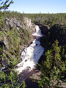
- Muddus waterfall with a height of 42 m about 10 km north of the entrance
- Moskoskoru, a 100 m deep canyon
Web links
- Muddus / Muottos National Park at the Swedish Environmental Protection Agency


