
Fulufjället National Park
| Fulufjället National Park | |||
|---|---|---|---|
 |
|||
|
|||
| Location: | Sweden | ||
| Next city: | Älvdalen | ||
| Surface: | 384.14 km² | ||
| Founding: | 2002 | ||
| Visitors: | 40,000 (2008) | ||
| Address: | Fulufjällets naturum, Box 128, S-790 90 Särna, Sweden | ||

The Fulufjället National Park ( Swedish Fulufjällets nationalpark ) in Dalarna comprises the entire Swedish part of the Fulufjäll , a mountain range on the Norwegian - Swedish border, and parts of the adjacent lowlands. The park is the largest of the Swedish national parks outside Norrbotten and the southernmost Fjäll National Park in Sweden. It covers 384.14 km² (of which 230.48 km² is wilderness area) and extends from an altitude of approx. 500 m to 1042 m ( Brattfjället ). The park area is owned by the State of Sweden, but the park administration is the responsibility of the Provincial Government of Dalarna County . The area, which has been under nature protection since 1973, has had the status of a national park since 2002. On the Norwegian side, the 82.5 km² Fulufjellet National Park has been part of it since 2012 .
190 km² in the core zone of the national park belong to the wilderness areas certified by the European Wilderness Society .
particularities
Typical for the park are bare mountain regions, jungle-like valleys and steep cliffs as well as lush mats of reindeer lichen . In addition, Sweden's highest waterfall, the 93 meter high Njupeskär, is in the national park. The altar ring in the middle of the fell is an archaeological site . The purpose of this circular stone image has not yet been clarified, it is assumed that it could be a place of worship or an old system for pickling . The Old Tjikko spruce, known for its old age, is also located in the national park .
Flora and fauna
65% of the national park is covered by tundra . The reindeer lichen forms particularly lush cushions here, as in Fulufjäll, unlike in the more northerly fell regions of Sweden, no reindeer graze. A total of 815 species of lichen and moss can be found in the national park. In addition, the dwarf birch , Scheuchzer's cottongrass and bristle grass are typical in the subalpine heath . The eastern flank of the fells is dominated by lichen-rich old forests with up to 500-year-old pines up to a height of 700 to 800 m. In the past, this region was partially used as summer pasture for cattle and goats, but today the forests are no longer managed. The vegetation of the gorges is characterized by tall shrubs of wolf monkshood , alpine milk lettuce and medicinal angelica . The deeper regions in the east of the national park are characterized by swamps and taiga vegetation .
In Fulufjäll there is the Old Tjikko spruce , which has the same genetic material as 9500 year old dead wood at its base. It is therefore sometimes referred to as the "oldest tree in the world".

Also noteworthy are the large amounts of dead wood , which arose from a major flood disaster in 1997 and which today represent a valuable biotope. At the end of August, up to 400 mm of rain fell here within 24 hours, the highest amount ever recorded in Scandinavia, which led to major landslides and floods. The river Göljån in the east of the national park was particularly affected, the water masses of which swelled 500 times. The up to 6 meter high tidal wave uprooted around 10,000 m² of wood.
The fauna of the national park is also extremely rich and includes, for example, brown bears , lynxes , beavers , otters , mountain and forest lemmings and elk . Wolf , wolverine and arctic fox are less common, the reindeer is missing here. The bird life includes the golden eagle , capercaillie and red grouse on as characteristic bird of the national park which is considered Unglückshäher .
Infrastructure
The visitor center of the national park is located in Mörkret, approx. 20 km west of Särna in the northeast of the Fulufjäll near the Njupeskär waterfall . 140 km of marked hiking trails lead through the park, including the southern section of the Kungsleden , Sweden's most famous long-distance hiking trail . There are 15 rest huts, including self-catering huts suitable for overnight stays . Activities in the core zone that could disrupt the experience of nature are prohibited. In the outskirts there is moose hunting, sport fishing , boat rentals and snowmobiling on set routes.
Fulufjället Gallery

Njupeskär

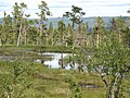
The high moor

Landscape in Fulufjället

Fulufjället in winter

View over the Fulufjäll

Old Tjikko (the oldest tree)


Web links
- Fulufjället. (No longer available online.) Dalarnas län , formerly in the original ; Retrieved September 6, 2008 (Swedish, park homepage). ( Page no longer available , search in web archives )
- Fulufjället - a guide to summer walks at fulufjället. (PDF) (No longer available online.) Dalarnas län , formerly in the original ; accessed on September 7, 2008 (English, hiking routes in the park). ( Page no longer available , search in web archives )
- Fulufjället National Park. (No longer available online.) PAN Parks / WWF , formerly in the original ; accessed on September 8, 2008 . ( Page no longer available , search in web archives )
map
- Fulufjället halls . In: Lantmäteriet (Ed.): Fjällkartan 1: 100 000 . W2. Gävle 2007, ISBN 978-91-588-9465-5 (hiking map).
Individual evidence
- ↑ ( page no longer available , search in web archives: panparks.org )
- ↑ ( page no longer available , search in web archives: dalarna.se )
- ↑ Leif Kullman: Världens äldsta nu levande träd finns i Dalarna. (No longer available online.) Umeå University , April 16, 2008, archived from the original on August 28, 2009 ; Retrieved April 30, 2010 (Swedish). Info: The archive link was inserted automatically and has not yet been checked. Please check the original and archive link according to the instructions and then remove this notice.
Abisko | Ängsö | Björnlandet | Blå Jungfrun | Dalby Söderskog | Djurö | Färnebofjärden | Fulufjället | Garphyttan | Gotska Sandön | Hamra | Haparanda Skärgård | Kosterhavet | Muddus | Norra Kvill | Padjelanta | Pieljekaise | Sonfjället | Sarek | Sculeskogen | Söderåsen | Stenshuvud | Stora Sjöfallet | Store Mosse | Tiveden | Töfsingdalen | Tresticklan | Tyresta | Vadvetjåkka