Tyresta National Park
| Tyresta National Park | ||
|---|---|---|
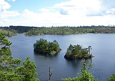
| Lake Stensjön | ||
|
|
||
| Location: | Stockholm County , Sweden | |
| Next city: | Haninge | |
| Surface: | 20 km² | |
| Founding: | 1993 | |
The Swedish National Park Tyresta is located southeast of Stockholm in the municipalities of Haninge and Tyresö .
It is located in a hill country formed in the Ice Age with primeval coniferous forests and stone blocks overgrown with lichen. Sand plains and lakes have formed in the crevices of the former rocky mountains. There are around 80 species of birds in the Tyresta National Park, including the capercaillie and various woodpeckers and owls .
In 1999 around ten percent of the national park fell victim to a fire in which not only the vegetation but also the peat layer underneath burned out completely. Some of the traces of this brand were still visible decades later. The ecosystem as a whole was not only able to recover from the disaster, but is now considered to be more diverse and species-rich in this part of the park than it was before the fire. In addition, the fire turned out to be a stroke of luck for archaeologists, who thus gained insight into numerous new, Stone Age sites under the burnt peat layer.
At the entrance to the national park there is an information center that presents all of the Swedish national parks. There is also a farm here that keeps rare Swedish domestic animals.
Tyrestahällen (No. Sö 270) is a runic inscription northwest of Tyresta by.
Web links
- Official website (Swedish, German)
Individual evidence
- ↑ 20 år sedan branden i Tyresta. Retrieved July 10, 2020 (Swedish).


