
Norra Kvill National Park
| Norra Kvill National Park | |||
|---|---|---|---|
|
|||
| Location: | Kalmar Lan , Sweden | ||
| Next city: | Vimmerby | ||
| Surface: | 1.14 km² | ||
| Founding: | 1927, expanded in 1994 | ||

Norra Kvill is a Swedish national park in the area of the municipality of Vimmerby , which consists of a primeval coniferous forest in the highlands of Småland .
No tree has been felled here for over 150 years, some pines are 350 years old, 35 meters high and have a circumference of 2.50 meters. The wilderness-like character is created by fallen trees and gigantic stone blocks. There is a rich flora on the forest floor . A partially relatively steep, marked path opens up the forest for visitors over a length of approx. 4 km. From the mountain Idhöjden, at 230 m above sea level. NN the highest point in the park, you have a wide view of the area. South of the national park is the thickest oak in Europe, the Rumskullaeken (also known as Kvilleken).
The park was established in 1927; In 1994 the area was expanded from 27 to 114 hectares.

Moss-grown stones

Rumskullaeken
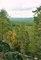
View over the national park


Web links
Individual evidence
- ↑ The Norra Kvill National Park | Visit Småland. (No longer available online.) In: www.visitsmaland.se. Archived from the original on July 20, 2016 ; Retrieved July 20, 2016 . Info: The archive link was inserted automatically and has not yet been checked. Please check the original and archive link according to the instructions and then remove this notice.
- ↑ National Park Facts | Norra Kvill National Park | Choose National Park | Sweden's national parks. In: Sveriges nationalparker. Retrieved July 20, 2016 .
- ↑ http://www.monumentaltrees.com/de/swe/kalmar/vimmerby/945_kvilleken/
Abisko | Ängsö | Björnlandet | Blå Jungfrun | Dalby Söderskog | Djurö | Färnebofjärden | Fulufjället | Garphyttan | Gotska Sandön | Hamra | Haparanda Skärgård | Kosterhavet | Muddus | Norra Kvill | Padjelanta | Pieljekaise | Sonfjället | Sarek | Sculeskogen | Söderåsen | Stenshuvud | Stora Sjöfallet | Store Mosse | Tiveden | Töfsingdalen | Tresticklan | Tyresta | Vadvetjåkka