Lule älv
|
Lule älv Luleälven, Luleälv |
||
|
Bridge over the Lule älv near Vuollerim |
||
| Data | ||
| location | Norrbottens län ( Sweden ) | |
| River system | Lule älv | |
| Union | by Stora Luleälven and Lilla Luleälven at Vuollerim 66 ° 26 ′ 44 ″ N , 20 ° 38 ′ 13 ″ E |
|
| Source height | approx. 76 m | |
| muzzle | at Luleå in the Gulf of Bothnia coordinates: 65 ° 34 ′ 12 ″ N , 22 ° 8 ′ 16 ″ E 65 ° 34 ′ 12 ″ N , 22 ° 8 ′ 16 ″ E |
|
| Mouth height | 0 m | |
| Height difference | approx. 76 m | |
| Bottom slope | approx. 0.17 ‰ | |
| length | 450 km (including source rivers) | |
| Catchment area | 25,240.5 km² | |
| Outflow at the level at the mouth |
MQ |
545 m³ / s |
| Reservoirs flowed through | Akkajaure , Stora Lulevatten | |
| Medium-sized cities | Luleå | |
|
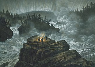
The Harsprånget waterfall was the largest waterfall in Lule älv until it fell dry by the Stora harsprånget hydroelectric power station. The lithograph by Carl Svante Hallbeck from 1856 shows the waterfall in the polar night with three spectators around the campfire, one of whom is standing and watching the northern lights |
||
|
Location of the Luleälv |
||
The Lule älv (also Luleälven or Luleälv ) is a north Swedish river that flows from the Scandinavian mountains into the Baltic Sea .
course
The Lule älv has a length of 450 kilometers and drains an area of 25,245 km². The two source rivers, Stora Luleälven and Lilla Luleälven , arise in the Sulitjelma massif and in the Sarek mountains . The Lule älv flows into the Bothnian Gulf at Luleå . The mean water flow (MQ) at the mouth is 545 m³ / s.
economy
The Lule älv is used intensively for the generation of hydro energy . There are 14 large hydropower plants along its course , including five of the ten largest hydropower plants in Sweden. The expansion has led to a radical change in the watercourse.
The Harsprånget hydropower plant , Sweden's largest hydropower plant, is located around 10 km south of the municipality of Porjus , where a power plant was also built. The use of the waterfalls for Stora harsprånget began as early as 1918, but it was not until 1952, after many interruptions, that the power station could be put into operation. Energy is generated here today with an output of 945 MW . Initially, the power station provided power to the mines and the railroad.
Between about 1864 and 1867 the canalization of the river began. Iron ore from the Gällivare region was to be transported to Luleå via the canal . However, the construction project known as the English Canal had to be discontinued after a short construction period due to the bankruptcy of the operating company. The clearest remains of the canal project can be found today near the villa area Trångfors on the outskirts of the city of Boden .
Web links
Individual evidence
- ↑ Sveriges Meteorologiska och Hydrologiska Institut (SMHI) - Län och huvudavrinningsområden i Sverige (PDF; 2.5 MB)


