
Kvikkjokk
| Kvikkjokk | ||||||
|
||||||
| State : | Sweden | |||||
| Province (län): | Norrbotten County | |||||
| Historical Province (landskap): | Lapland | |||||
| Municipality : | Jokkmokk | |||||
| Coordinates : | 66 ° 57 ' N , 17 ° 43' E | |||||
| Height : | 320 m above sea level | |||||

Kvikkjokk is a small northern Swedish town in Lapland . Due to its location on the eastern edge of the Swedish fells , it is the starting point or end point for excursions to the Sarek and Padjelanta national parks and the neighboring areas.
Geographical location
Kvikkjokk is located about 120 km northwest of Jokkmokk on the Tarra River delta, which joins the Kamajokk here.
climate
Since only three months have an average temperature of over 10 ° C and the coldest month does not exceed −3 ° C, Kvikkjokk can be assigned to the subarctic climate zone ( effective climate classification : Dfc). The climate is characterized by very long, cold winters, which often begin with the first snowfall at the beginning of October and usually end in mid-May with the last snow disappearing . In the cool and short summer there is much more precipitation than in the winter, which is nevertheless quite snowy. Protected from the maritime influence by the surrounding mountains , the climate in Kvikkjokk is far more continental than on the coast of Norway , which among other things means that in winter, favored by the valley location, the lowest night temperatures in Sweden are often recorded in Kvikkjokk.
The coldest temperature ever recorded in Kvikkjokk was registered on January 1, 1918 at −43.0 ° C, while the highest temperature ever recorded was 32.0 ° C on July 1, 1945. Further extreme values were recorded on June 13, 1972 with the highest daily precipitation (50.4 mm) and on March 1, 1906 with a record snow depth of 159 cm. The highest snow cover a winter averages 98 cm and the lowest recorded maximum temperature of a year was 21.9 ° C in 1962, whereby it is mostly between 25 ° C and 27 ° C.
|
Average monthly temperatures and rainfall for Kvikkjokk-Årrenjarka 1961–1990
Source: SMHI
|
||||||||||||||||||||||||||||||||||||||||||||||||||||||||||||
history
There are remains in the Kvikkjokk area from the Stone Age and later from the Viking Age . Above all, however, the place was shaped by the Sami inhabitants , who still make up a large part of the population today. Old Sami sacrificial sites are near Kvikkjokks.
When silver was found in Sarek am Alkajaure near today's chapel in the 17th century, a first settlement was built west of today's town center on the opposite bank of Gamajåhka (Kamajokk). Parts of the silver processing equipment have been preserved to this day. The older parts of Kvikkjokk Church also date from this period.
As part of his Lapland expedition, Carl von Linné stayed there in 1732 . He described this trip in his trip to Lapland .
Culture and sights
The wooden church, the remains of silver mining from the 17th century and the rapids of Kamajåkk are worth seeing.
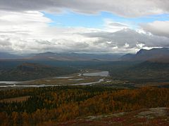
Overall view from the “local mountain” Sjnjerak

Kvikkjokk Church
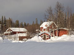
The town center in winter 2005

The Kamajåkk just before its mouth at Kvikkjokk


Economy and Infrastructure
traffic
By land, Kvikkjokk can only be reached via the 100-kilometer road 805 from Jokkmokk , which also ends there. The buses of Länstrafik i Norrbotten travel to Kvikkjokk from Jokkmokk, which in turn has bus connections to the railway stations Murjek , Älvsbyn , Boden and Luleå (there also the airport ) and the connection to Inlandsbanan.
Long-distance hiking trails
The Kungsleden leads through the village ; the Padjelantaleden and an arm of the Nordkalottleden begin and end there.
activities
Walks nearby
There are hiking trails to the peaks of the surrounding mountains: Prinskullen, Nammatj, Sjnjerak and Vallespiken. Another hiking trail leads to the old mill from the 18th century. There is a 23-kilometer hiking trail to Årrenjarka across the Sjnjerak and Kuossavare mountains. From there bus connection to Kvikkjokk.
Paddling / delta tours
At the Fjällstation you can rent canoes with which you can paddle around in the delta, for example, and also reach the “bathing lake” of Kvikkjokk, the water temperature of which can reach 18 ° C when the weather permits. There are also guided motorboat tours.