Rapa River
|
Rapaälven Rapaätno , Ráhpaädno |
||
|
Lower Rapaätno |
||
| Data | ||
| location | Sarek National Park in Norrbotten County ( Sweden ) | |
| River system | Lule älv | |
| Drain over | Lilla Luleälven → Lule älv → Baltic Sea | |
| from the source rivers | Smájllajåkkå, Mikkájåkkå, Guohperjåkkå Áhkáåkkå and 67 ° 17 '0 " N , 17 ° 37' 0" O |
|
| muzzle | in the Lilla Luleälven coordinates: 67 ° 7 '48 " N , 18 ° 15' 29" E 67 ° 7 '48 " N , 18 ° 15' 29" E |
|
| Mouth height |
498 m above sea level
|
|
| length | approx. 75 km | |
| Flowing lakes | Laitaure , Tjakttjajaure | |
| Communities | Jokkmokk | |
|
The Rapa River flows into the Laitaure |
||
|
The Rapa Delta |
||
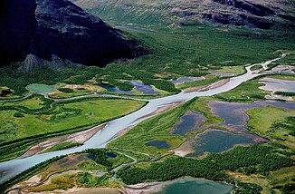
Rapaälven (also Rapaätno , Sami Ráhpaädno ) is the largest river in the northern Swedish Sarek National Park in the municipality of Jokkmokk . It drains a large part of the national park over a length of approx. 75 km.
The Rapaälven river arises from the four smaller rivers Smájllajåkkå, Mikkájåkkå, Guohperjåkkå and Áhkáåkkå in the center of Sarek National Park. These four rivers are in turn fed by 30 glaciers. Therefore, the Rapaälven carries around 180,000 tons of glacier debris every year. It deposits this glacier rubble in its two delta landscapes - the Rapaselet, a silted lake and the Rapa delta at its mouth in the Laitaure .
The Rapadal is formed by the Rapaälven and bordered by mountains up to 2000 meters high. Because of its width and depth, the river is difficult to cross on foot.
Web links
literature
- Drexhage, Rebecca and Hell, Benjamin: Sweden: Sarek, Stein Verlag 2007, ISBN 978-3-86686-017-9
- Heim, Dietmar and Klawatzki, Dirk: Sweden: Sarek, Stein Verlag 1998, ISBN 3-89392-117-6
- Fjällkarta BD10: Sareks National Park


