
Inarijärvi
| Inarijärvi | ||
|---|---|---|

|
||
| Geographical location | Lapland ( Finland ) | |
| Tributaries | Juutuanjoki , Ivalojoki , Kirakkajoki , Siuttajoki , Nellimjoki , Nachbarujoki | |
| Drain | Paatsjoki | |
| Islands | Hautuumaasaari , Ukonkivi | |
| Places on the shore | Inari | |
| Data | ||
| Coordinates | 68 ° 58 ' N , 27 ° 43' E | |
|
||
| Altitude above sea level | 118.7 m | |
| surface | 1 084.33 km² | |
| volume | 15.5 km³ | |
| Maximum depth | 92 m | |
| Middle deep | 14.3 m | |
| Catchment area | 14,512 km² | |

The Inarijärvi [ inɑrijærvi ] ( Inari Sami : Aanaarjävri , Northern Sami : Anárjávri skoltsamisch : Aanarjäu'rr Germanized even Inarisee ) is a lake in the Finnish part of Lapland in the municipality of Inari . It is the third largest lake in Finland .
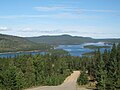
The Inarijärvi is located north of the Arctic Circle about 1,100 kilometers north of Helsinki . Due to this location, in cold years it can happen that the lake is frozen until June. The maximum water depth is 92 meters. With over 3,000 islands, in some parts it gives the impression of a labyrinth of waterways rather than that of an open lake. The Inari Lake is surrounded by pine forests. The lake drains into the Arctic Ocean via the Paatsjoki . On its west bank on the European route 75 is the place Inari with the Museum Siida , which is dedicated to the culture and history of the Sami and the nature of the region.
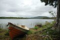
Still life on the shore

Seaplanes on the shore
Inarijärvi


