Västergötland
| Västergötland | |
|---|---|

|

|
| Basic data | |
| Part of the country (landsdel) : | Götaland |
| Province (län) : | Västra Götalands län , Jönköpings län , Hallands län and Örebro län |
| Surface: | 20,554 km² |
| Residents: | 1,229,167 (December 31, 2008) |
| Population density: | 59 inhabitants per km² |
| Highest elevation: | Galtåsen 361 m ö.h. |
| Largest lake: | Vänern |
is ahistorical province(Swedish landskap) inSweden. It borders in the south on the historical province ofHalland, in the west on theKattegatand the historical provincesDalslandandBohuslän, in the north onVärmlandandNärkeand in the east onÖstergötlandandSmåland.
geography
Västergötland offers a varied landscape. The south and east is a hilly landscape that belongs to the southern Swedish highlands and its foothills. The north and west belong to the Central Swedish Depression and form the Västgöta plain surrounded by table mountains . The mountains, which overlook the plain by an average of 100 meters, are called Västgötabergen in Swedish . In the north-west and north-east the two largest Swedish lakes Vänern and Vättern form the boundaries of the province. The largest river is the Göta älv , which drains the Vänern into the Kattegat .
Västergötland has a humid but not very cold climate with an annual rainfall of up to 900 mm on the coast and 600 mm in the plain and an average temperature of −1 ° C in January and 15 ° C in July (24-hour average ).
Västergötland's largest city is Gothenburg , other important cities are Borås , Lidköping , Mariestad , Skara , Skövde , Trollhättan and Vänersborg .
economy
Västergötland is one of the most important agricultural areas in Sweden. Agriculture - strongly rationalized - still plays an important role in the economic life of the province. The industrial development was diverse, the port city of Gothenburg , Trollhättan (including Saab ), Skövde (including the Volvo Penta plant) and Borås (textile industry) have developed into industrial centers.
history
A first settlement can already be seen around the 8th millennium BC. To be dated. Starting from the coast, the land was settled along the rivers and lakes. Around 3000 BC There was already a well-developed social organization, as shown by a number of passage graves, especially around the city of Falköping . Rock carvings and sacrificial finds, such as finely forged bronze shields, which are exhibited in the Provincial Museum in Skara , date from the Bronze Age . Other forms of burial sites such as barrows and ship settlements provide evidence of the culture of the following periods. Treasure finds and rune stones complete the picture for the time of the Great Migration and the Viking Age .
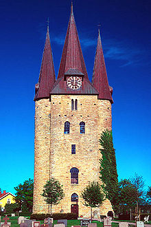
Västergötland was probably the earliest part of Sweden to be Christianized. Olof Skötkonung was the first Swedish king to be baptized in Husaby , near the city of Skara, around the year 1000, and the first Swedish diocese - with the Skara Cathedral as its center - was founded in the 11th century. Västergötland was politically and culturally relatively independent in the Middle Ages. It had its own law (Västgötalagen), its own thing and its own judges. At that time Västergötland bordered on the south and west of Denmark , with which it had lively trade connections. It only had two cities of importance, Lödöse at the mouth of the Göta älvs and Skara. Nevertheless, Västergötland also played an important role in imperial politics. Three of the medieval royal families came from Västergötland.
Under Gustav Wasa , Västergötland became a unified province, but Västergötland was divided during the administrative reform of 1634. Since Västergötland bordered Denmark and Norway , the border areas in particular were drawn into the armed conflicts. The border areas to Halland were particularly hard hit by the Northern War of 1563–70, in which large parts were completely devastated.
Around 1600, several important cities were founded in Västergötland: Mariestad 1583, Gothenburg 1619–1621 and Borås 1621. Other cities were founded, for example Trollhättan 1910, at the beginning of the 20th century.
coat of arms
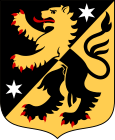
The coat of arms shows a red-armored and red-tongued lion with mixed up colors in the obliquely left-hand divided field in black and gold , each accompanied by a silver star above the dividing line .
Attractions
Apart from Gothenburg , which as a big city and historically important port and trading city offers a whole range of sights, those interested in history can visit the city of Skara and the area around Skara (medieval sights) as well as the area around the city of Falköping (tombs from different periods ) are recommended. The baroque castle Läckö is also worth a visit. in the town of Borås is the industrial history interesting Textile Museum, and the Museum Boras that the remains of the bog body of Dannike-woman shows of the 17th century. Trollhättan is also interesting from an industrial history perspective. The Göta Canal between Vättern and Vänern is particularly attractive .
Nature enthusiasts will find an untouched landscape in the Tiveden National Park . Not only do a large number of bird species nest at Lake Hornborgasjön , in April thousands of cranes also recover from crossing the Baltic Sea. The table mountains Billingen and Kinnekulle offer extensive hiking trails and Halleberg and Hunneberg are not only royal hunting grounds, but also have the densest elk population (elk safaris).
Landscape symbols
See also
- Daniel of Sweden , Duke of Västergötland
- Victoria of Sweden , Duchess of Västergötland
- Floium
Web links
- Official website (English, German, Swedish)
- West Sweden (English, German, Norwegian, Swedish)
Individual evidence
- ↑ Folkmängd i landskapen ( Memento from August 17, 2013 in the Internet Archive )

